New Technical Standards Improving the Quality in Positioning and
Measurement
by
Jean-Marie Becker, Hansbert Heister and Vaclav Slaboch
Key words: Surveying Instruments, Checking,
Testing, Calibration, ISO and CEN Standards.
Abstract
1. Introduction
This paper informs about the latest development in the field of
survey instruments and survey methods. These are characterised by
introduction of new information technology. Nowadays these new
technologies are represented mainly by GPS, Total Stations, Electronic
Levels, RTK, Laser Instruments and other new measuring devices. The
new instruments resulted in a revolution in positioning characterised
mainly by increased accuracy, speed and seemingly simple use. But
these "advantages" may hide some dangers and traps which
must not be neglected, and which might in the end lead to degradation
of surveying profession.
Possibility to achieve practically "any degree of accuracy and
speed" could result in unnecessary increase of cost of
positioning and in saturation of GIS data basis.
A comfortable and easy operation of the electronic "black
boxes" could lead to underestimation of operator’s
qualification and consequently to blunders resulting in enormous
losses with the clients.
One of the ways to escape out of these traps of modern technology
is standardisation. Here we want to mention three main areas which in
our opinion are most relevant to the tasks of positioning and where
the most important changes have been made:
- standards for survey equipment
- standards for laboratory calibration and testing
- standards for positioning within the family of standards for
geographic information and geomatics.
2. Standards for Survey Equipment
Existing ISO activities concerning survey instruments are
concentrated in several technical Commissions (TC59/SC4 a TC172/SC6).
Unfortunately the existing standards are taking into account either
the construction or manufacture points of view only. Since 1997 a
Joint Working Group for both TC`s have been created with the aim to
prepare for approval a new set of standards for "Field Procedures
for Determining the Accuracy of Surveying Instruments". A draft
proposal of this "new" standard is now ready and has been
sent to national standard organisation for approval.
3. Standards for Laboratory Calibration and Testing
Unfortunately not all the Standards allow checking, testing and
calibration to be carried out uniquely in the field. In many instances
engagement of metrological procedures is required. The application of
metrological procedures is justified also by new aspects of Quality
Management as required by Standards ISO 9000 and also by increasing
complexity of measuring systems which are reflected in completely new
methods of calibration.
There are many excellent geodetic laboratories for testing and
calibration of survey instruments, but not all of them comply with the
metrological confirmation system as defined by ISO 10 012/1. The
traditional methods for checking, testing and calibration of the major
part of geodetic instruments are partly or totally outdated. New
instruments have to be tested as complete systems consisting of
interconnected sensors, firmware, application software, data
acquisition, data transfer and user interface. To establish reliable
procedures for calibration a continuous dialogue between the surveyors
and metrologists is indispensable.
4. Standards for Positioning Geographic Information
Activities on Standards related to positioning of Geographic
Information are being treated mainly by ISO/TC 211 and by CEN/TC 287.
Most of the pre-standards are now completed or short before
completion. If we consider that according to GIS specialist over 80 %
of all activities on global, national and regional level have spatial
or geographic aspect it is no surprise that the initiative for
standardisation in this field came from the GIS experts and not from
surveyors. The most important documents are ISO/WD 15045-11.8
Geographic Information/Geomatics – Part 11: "Spatial
Referencing by Co-ordinates" and pre-standard ENV 12762:1998:
Geographic Information – Referencing Direct Position". The
increasing adoption of modern survey instruments and namely GPS for
positioning and navigation makes it necessary for surveying profession
to ensure national and international standards for geo-referencing and
spatial co-ordinate positioning. These standards are ensured by
Control Networks, Grid Transformation and Geoid Models. GPS and Global
aspects will prevail in the long term.
5. Conclusion
Since 1995 FIG WW in Berlin FIG has established liaison with ISO/TC
211 Geographic Information/Geomatics. In 1998 FIG Task Force for
Standards was created and FIG Commission 5 "Positioning and
Measurement" included in its working plan activities dealing with
Standards, Quality Assurance and Calibration. The mission of the FIG
in this field is to adapt the new standards to modern surveying
technologies and technical developments and to assist individual
surveyors to select optimum procedure for given tasks.
Prof. Jean-Marie Becker
National Land Survey of Sweden
S-801 82 Gävle
SWEDEN
Email: jean-marie.becker@lm.se
Prof. Hansbert Heister
UNIBW München
D-85577 Neubiberg
GERMANY
Email: heister@glabse.bauv.unibw-muenchen.de
Dr. Vaclav Slaboch
Research Institute of Geodesy
Topography and Cartography
CZ-250 66 Zdiby 98
CZECH REPUBLIC
Email: Vaclav.Slaboch@vugtk.cz
New Technical Standards Improving the Quality in Positioning and
Measurement
1. INTRODUCTION
The purpose of this paper is to inform about the
latest developments in the field of standards survey instruments and
survey methods. They are first of all characterised by introduction of
new information technology. These new technologies are represented
mainly by GPS, Total Stations, Electronic Levels, RTK, Laser
Instruments and other new measuring devices. The new instruments
resulted in a revolution in positioning characterised mainly by high
accuracy, speed and seemingly simple use. But these
"advantages" may hide some dangers and traps which must not
be neglected, and which might in the end lead to degradation of
surveying profession. Possibility of achieving practically "any
degree of accuracy and speed" could result in unnecessary
increase of cost of positioning and in saturation of GIS data basis.
A comfortable and easy operation of the electronic
"black boxes" could lead to underestimation of operator’s
qualification and consequently to blunders resulting in enormous
losses with the clients.
One of the ways to escape out of these traps of
modern technology is standardisation. Here we want to mention three
main areas which in our opinion are most relevant to the tasks of
positioning and where the most important changes have been made:
- standards for survey equipment
- standards for laboratory calibration and testing
- standards for positioning within the family of standards for
geographic information and geomatics
2. STANDARDS FOR SURVEY EQUIPMENT
The surveying profession has been subject to a
rapid technical evolution concerning techniques and equipment. Today
Surveyors commonly use digital levels, laser planes, total stations
and GPS, however ISO (International Standard Organisation) has not yet
succeeded to put on the marked standards for these new instruments.
ISO still works hardly with updating and harmonisation of earlier
standards for older instruments as example EDM, theodolites and
levels.
Inside ISO, several Technical Commissions (TC59/SC4
and TC172/SC6) have produced standards for levelling instruments.
Unfortunately these standards made for the same instrument and for the
same purpose namely "Field procedures for determining the
accuracy of surveying instruments" are often quite different
because of different goals of the TC’s. TC59 investigated the
standards from the building construction point of view and TC172 from
the instrument manufacturer point of view.
Since 1997 a Joint Working-Group for both TC’s
works on a harmonisation and updating of existing standards. The goal
is one standard for one instrument type. One of the projects concerns
levels and is chaired by J-M Becker. A reviewed draft proposal has
been discussed in Berlin March 1999 and sent to the National Standard
Organisations for comments and approval.
The following paper presents firstly general and
specific surveyor requests on standards, thereafter the recommended
field procedures for the determination of achievable precision with
levelling instruments for different applications. A simplified and a
full test procedure will be described. But no practical examples are
given because a lack of place. For more details we recommend to read
ISO standards
2.1 Objectives
The objectives for the standards are to specify
field procedures to be followed each time the achievable precision or
"accuracy" for a given surveying instrument used together
with its ancillary equipment (tripod, staffs, etc) has to be
determined. This will allow the surveyor to investigate that the
precision in use of the measuring equipment is appropriate to the
intended-measuring task.
2.2 Requests on standards
The common requests are as follow: only one
standard for each type of instrument who can be
used anywhere and whiteout any
special equipment by common field operators (technicians
as well as academics). That is to eliminate confusions, difficulties
in application and in interpretation.
Before any fieldwork the surveyor has to answer to
the following question:
"Can I achieve the required
accuracy in the project with my equipment, yes or no?"
The answer depends on each involved survey team
composition (instruments, ancillary equipment, personal), execution
times, project specifications, environmental conditions like
meteorology, vegetation, ground surface, etc. The question can also be
more general concerning several teams, equipment, projects, time for
execution, etc. The Surveyor has to be convinced that if he applies
the standards they will help him, otherwise he will not apply them.
For these reasons the surveyor asks for user friendly standards,
low in time consumption (about ½ hour) and with results easy to
interpret.
2.3 Field test procedures
The procedures described in this paper are designed
for field and not for laboratory use. The results are
specific for each determination and representative only for the
particular conditions existing at that time: weather,
environment, ground surface, equipment, staff members, etc. The
equipment must always be acclimated to the environmental temperature
and adjusted before testing in accordance with the manufacturer
handbooks.
2.4 The full field test procedure
This field method is proposed for the determination
of the highest achievable precision using one specific type of
levelling equipment. Normally it is for the purpose of precise
levelling where high accuracy is demanded and the set-up
observations are made with equal lengths of backsights and
foresights. The accuracy will be expressed in terms of the standard
deviation for 1km double-run levelling.
For implementation of this test we have to
establish a test line AB of about 60m in a plane area with homogenous
ground surface (gravel preferably) free from vegetation or other
disturbing factors (water plane, grass). The points A and B have to be
stable during the whole operations. The chosen site lengths will be
about 30m, which is the recommended distance for precise levelling in
most countries.
Note:
- A variation of 10% between the site lengths at each set-up can
be accepted. That is a realistic tolerance compatible with normal
field applications.
- Also greater site lengths (up to 50 – 60m) can be used for the
purpose of testing the equipment’s capacity and range of
accuracy or according to project specifications.
- All factors specific for each test: equipment, ground surface,
vegetation, weather conditions, operators, etc. have to be
documented.
The observation procedure:
The measurements are made in two sets with
interchanging the positions of the staffs between A and B. Each set
consists of n-pairs of readings (preferably 20) backwards to
staff A - forward to staff B and vice-versa, resulting in n-height
differences. Between each pair of readings a new instrumental
set-up has to be made. All details about how to operate, calculate
and evaluate are described in the coming standard with one example in
appendix.
Evaluation of the results:
The results analysis is made with statistical tests
helping the surveyor to decide whether his equipment allows him to
achieve the expected accuracy.
2.5 Simplified field test
This test is based on a limited number of
measurements (minimum 10) for checks of levelling equipment used
especially at construction sites where radial measurements with
unequal sight lengths at each set-up are of common use.
Equal sight lengths are exceptions.
Establishment of a test line:
In a relatively plane area two points A & B
have to be monumented at a distance corresponding to the maximum and
minimum sight length ranges that will be used inside the specific
project. As an example if inside a construction project the needed
sight lengths are between 10 and 70m, the distance for AB will be
about 80m. The points A and B have to be stable during the test
period.
Observation procedure:
The measurements are made in two different steps:
The first step with equal
sitght length (40m) is a copy of the accurate test described
above limited to 10 set-ups. The goal is to determine a reference
height difference between A and B, value that is considered as the
true value of the height difference of the levelled
points A and B.
For the second step the instrument is
placed so that the maximum eccentricity for the set-ups is used: in
our example 10m and 70m (Fig.1). Again all observations on both staffs
A and B are made for 10 set-ups.
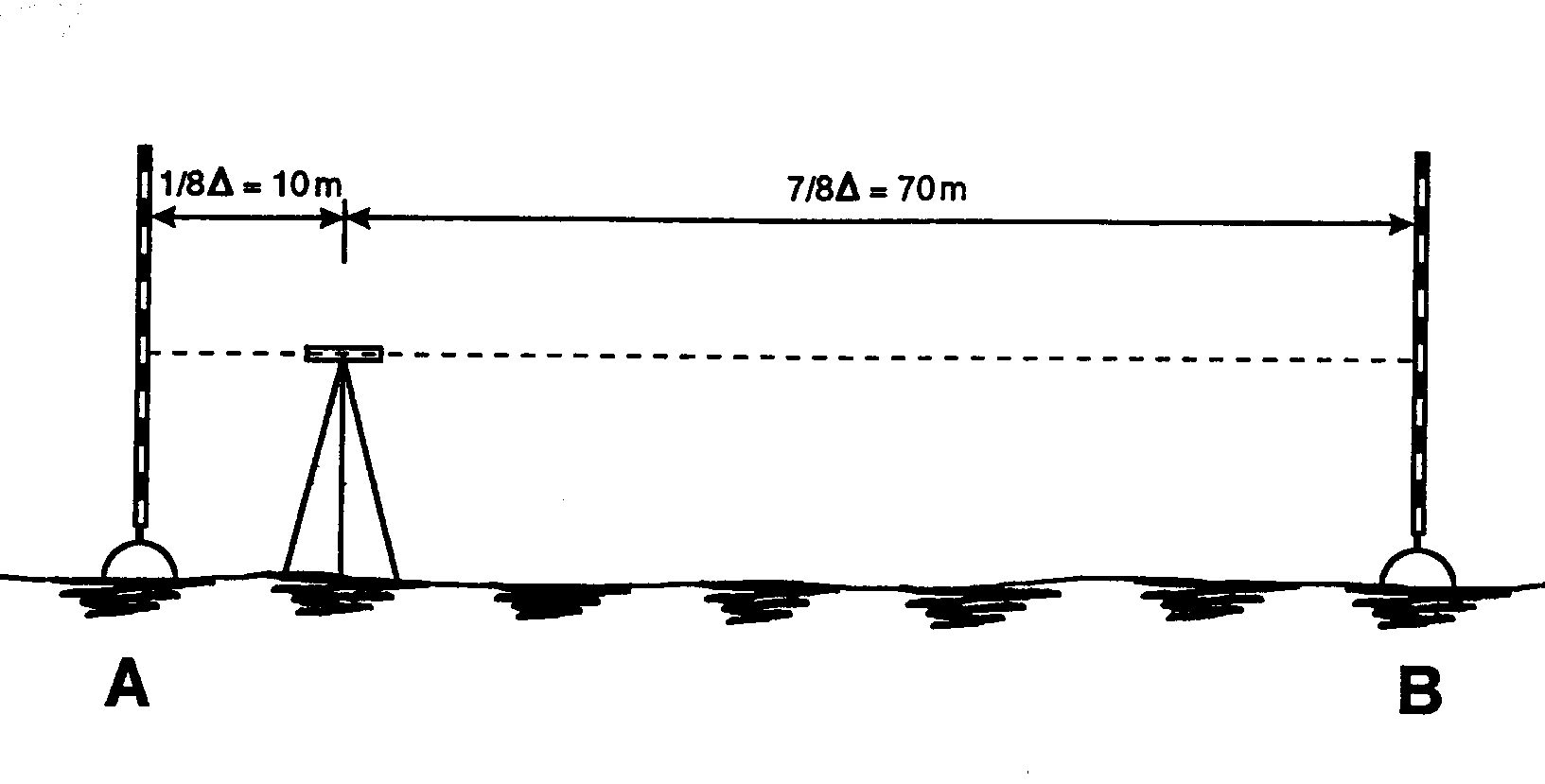
Fig. 1: Second configuration of the test line for
the simplified test method
2.6 Conclusion
FIG-C5 is grateful that the ISO Technical
Committees TC59 and TC172 have taken in account the requests of the
surveying community for the updating and harmonisation of existing
standards. We also have noticed that efforts are undertaken to prepare
standards for the new generation of survey instruments like
total stations, laser-planes and perhaps GPS. We hope that these
standards will soon be reality.
FIG Commission 5 will contribute with its experts (WG
5,1) to the elaboration of this standards through collaboration with
ISO. Furthermore FIG-C5 will help the surveyors to implement these
standards in the best way.
3. STANDARDS FOR LABORATORY CALIBRATION AND TESTING
In contrast to the field procedures, discussed in
chapter 2, the standards, the strategies and approaches, of laboratory
tests and calibrations for modern surveying instruments are very
poorly defined or even introduced in practice. Though these
metrological procedures become more and more justified also by new
aspects of quality management systems as required by standards of ISO
9000 family and also by the complexity of new electronic measurement
systems. Documented procedures for a uniform approach are not yet
available for the majority of the new instruments.
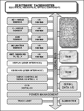 |
Fig.2: Opto-electronic structure of a modern
tacheometer |
The old notions concerning the external structure
of e.g. a theodolite, from which you could derive well defined
procedures for handling, checking, adjusting or calibrating, are
partly totally out-dated. Modern surveying instruments are better
structured on the base of sensor components or functionality (Fig. 2)
This points out much better the opto-electronic concept and clarifies
additionally interconnection of sensor units, firmware, application
software, data acquisition, data transfer and user interface.
Operation of these hybrid systems has become as complex nowadays
making it nearly impossible to survey all functions. The first
initialising procedure of an electronic tacheometer can require more
than 100 (!) operating steps (keystrokes) and settings. Multitude of
instructions and data entry not only has the advantage of extended
applications but also is implying as well for the manufactures as for
the user to produce (instrumental) errors (Hennes, 1998). The complex
sequence from original sensor signals to final results often makes it
impossible to locate the reason for a wrong measuring result.
Furthermore it is impossible to decide if this was a user´s wrong
operation or a failed measurement. The interaction of configuring an
instrument, controlling, correcting and data processing demonstrates
Fig. 3. That is why it becomes more and more difficult to design
robust checking methods. Particularly it is advised to check
preferable sensor groups or if possible the complete measuring device
using a most simple but effective and representative procedure.
In practice this is not so easy, but first
rudimental proposals were published (Gottwald, 1998, Fischer 1998). It
is a major task for manufacturers, universities or other institutions
specialised on this field to prove new test methods with respect to
recent developments and short innovation cycles. Moreover it is
important that these procedures were economically reasonable and
accepted in practice is as much as possible.
Gottwald, 1998 and Staiger, 1998 propose a stepwise
proceeding in 4 phases. Phase 1 and 2 consist of routine checks
respectively field procedures. They comprise all these actions, which
may and have to be realised by the surveyor in the field or short-time
before survey Beside the FIG publication (1994), which relates to EDM,
the new drafts of ISO 17123 – 1,2,3, 4 specify investigations to
verify appropriate functioning and to determine accuracy in use for
levels, theodolites and EDM´s. All proposed procedures are field
tests without the need of special additional equipment.
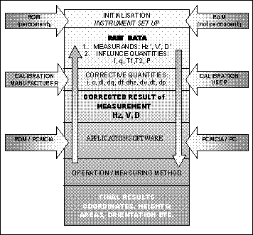 |
Fig. 3: Measuring process of microprocessor
controlled surveying instrument |
Phase 3 and 4 encompass calibration and extensive
testing for acceptance and performance. They demand for a high grade
test equipment and reference conditions, where traceability is
guaranteed.
In general preferring of so called system
calibration or system checks can be observed. The objective
is to aspire to a global test, which confirms correct functioning of
all relevant sensors, controlling firmware and the application
software. Without knowledge of the specific behaviour of a single
sensor final results are compared to reference quantities. E.g.
Fischer 1998 describes a proposal and simulation results of
investigating a tacheometer.
The practice in calibrating digital levels (phase
3, 4) is similar, but already better proved. Without knowledge of the
code, the correlation model and the imaging process system
calibration yields representative quantities for scale, accuracy,
resolution, stability or drift (Pietsch, 1992, Heister, 1994,
Reithofer et al., 1996).
The theme quality control and metrological
confirmation becomes much more confusing with regard to GPS
technology. Though the system is already well established and
successfully used in surveying, published methods for checking and
calibrating satellite positioning systems are only a few (Bäumker,
Fitzen 1996, Ingensand 1997, Landau, 1998, Stewart et.al. 1998) and no
common standard.
It is obvious that there are two major reasons for
reconsidering new test (calibration) methods, which can only be
realised by qualified technical staff:
- New technologies have radically influenced the design of
surveying equipment that traditional methods for investigating
instruments have become more less obsolete.
- A state of the art quality management system (QMS) demands for a
metrological confirmation system, which should include documented
procedures for field and lab checks. The old instructions
do not cover all the requirements of the QMS. For the time being
there are no standards (ISO, EN etc.) closing the gap properly.
In order to attain new concepts for economical
acceptable test (calibration) method it is necessary that
- the chain from the uncorrected measurands to final results is
documented by manufacturers in all details (reference manual),
- the instrument can be reset any time in a controlled basic
configuration with clearly documented defaults,
- user friendly operation with a minimum of misoperations is
provided,
- simple but effective testing methods (4 phases model) are
proposed by manufacturers, universities or other qualified
institutions,
- independent accredited calibration laboratories are to
constitute, guaranteeing traceability and which are specialised on
investigating geodetic equipment. These institutions should be
able issuing calibration certificates in accordance with the WECC
or any other international organisations.
These remarks may stimulate the discussion about
instrument testing between practitioners and experts with the
objectives to establish new guidelines for calibration or performance
tests, procedures for effective checking the functional units of the
"black-boxes". But new guidelines have as well to be set up
data processing procedures, to guarantee reliable results and best
accuracy.
4. STANDARDS FOR POSITIONING GEOGRAPHIC INFORMATION
Activities on Standards related to positioning of
Geographic Information are being treated mainly by ISO/TC 211 and by
CEN/TC 287. Most of the pre-standards are now completed or short
before completion. If we consider that according to GIS specialist
over 80 % of all activities on global, national and regional level
have spatial or geographic aspect it, is no surprise that the
initiative for standardisation in this field came from the GIS experts
and not from surveyors. The most important documents in this field are
ISO/WD 15045-11.8 Geographic Information/Geomatics – Part 11:
Spatial Referencing by Co-ordinates and pre-standard ENV 12762:1998:
Geographic Information – Referencing – Direct Position.
Continuously increasing adoption of modern surveying instruments and
namely GPS for positioning and navigation makes it necessary for
surveying profession to ensure national and international standards
for geo-referencing and spatial co-ordinate positioning. Control
Networks, Grid Transformation and Geoid Models should gurantee these
standards. Due to a continuously increasing global aspects of
geographic information positioning by GPS methods will gain on
importance in the long run.
Geographic Information can be defined as any
information that can be referenced to a location on the Earth.
Importance of Geographic Information is is increasing as it is used
more and more commonly for decision making by governments, enterprises
and private citizens. Spatially positioned data exerts in the modern "information
society" a great influence over our daily lives both now
and in the future. If we define surveying as an "art of
positioning" the application of geographic information in
the Information Society represents a great challenge for our
profession.
Only well positioned information (in space as well
as in time) can provide a reliable platform for information services
based on data derived from both terrestrial and airborne resources.
The fact that geographic information is more and more important in
growing number of applications such as transport, telecommunications,
environment, agriculture, marketing, medicine, geology, etc, stresses
the importance of common standards including for positioning. This
concerns all levels of positioning local, national, continental and
global. These standards should ensure full seamless interoperability
of all spatial information. Any negligence in unique standard
definition of the reference systems or lack of accuracy in positioning
can lead to great losses in time and money if not to a complete
inoperability of information systems based spatially located data.
A vision of so called "Digital
Earth" was presented at the IST 99 Conference in Helsinki
as "an integrated, distributed and easily accessible rich source
of geo-referenced information and tools". This vision the can be
achieved only if we manage to develop tools, data sets and methods to
integrate geographic information into the Information Society. To
develop these tools means not only to provide appropriate platforms
and multimedia instruments but first of all to base the information
on reliably spatially and temporally referenced data.
5. CONCLUSION
Since 1995 FIG WW in Berlin FIG has established
liaison with ISO/TC 211 Geographic Information/Geomatics. In 1998 FIG
Task Force for Standards was created and FIG Commission 5
"Positioning and Measurement" included in its working plan
activities dealing with Standards, Quality Assurance and Calibration.
The mission of the FIG in this field is to adapt the new standards to
modern surveying technologies and technical developments and to assist
individual surveyors to select optimum procedure for given tasks.
Surveying profession must also be able to provide and maintain
reference frames, which would enable integration of geographic
information (based on spatial and temporal positioned data) into the
Information Society. This is one of the most important tasks of
surveying profession at present.
REFERENCES
Becker, J.-M.: The new updated ISO Standards for
Survey equipment. in: Geodesy Surveying in Future, Gävle, Sweden,
1999.
Becker, J.-M.: History and evolution of height
determination techniques especially in Sweden. Surveying in Future,
Gävle, Sweden, 1999.
Bäumker, M., Fitzen, H.-P. (1996): Permanente
Überwachungsmessungen mit GPS. In: Brandstätter/Brunner/Schelling(Hrsg.):
Ingenieurvermessung 96, Ferd. Dümmler´s Verlag, Bonn, p. B7/1 –
B7/12
Fischer, E.-N.(1998): Prüfung elektronischer
Sensorsysteme bei elektronischen Tachymetern. Allgemeine
Vermessungs-Nachrichten (AVN), p. 374 – 378.
Gottwald, R. (1998): Prüfung und Kalibrierung von
Vermessungsinstrumenten. Vermessung, Photogrammetrie, Kulturtechnik,
p. 409 – 413.
Heister, H.(1987): Zur automatischen Kalibrierung
geodätischer Längenmeßinstrumente. Schriftenreihe des Studiengangs
Vermessungswesen der Universität der Bundeswehr München, Heft 27.
Heister, H.(1994): Zur Überprüfung von
Präzisions-Nivellierlatten mit digitalem Code. In: Schriftenreihe des
Studiengangs Vermessungswesen der Universität der Bundeswehr München,
Heft 46, p. 95 – 101.
Heister, H. (1996): Qualitätsssicherung und
Kalibrierung geodätischer Meßmittel. In: Brandstätter/Brunner/Schelling(Hrsg.):
Ingenieurvermessung 96, Ferd. Dümmler´s Verlag, Bonn, p. C2/1 –
C2/9
Hennnes, M (1998): Tachymeter – Technologien,
Instrumentenfehler, Kalibrierung. Paper presented at DVW- AK 5
Workshop, Febr. 16./17., Darmstadt.
Ingensand, H.(1997):Neue Verfahren zur
Zertifizierung geodätischer Messinstrumente. In: IX. Internationale
Geodätische Woche Obergurgl, Institutsmitteilungen der Universität
Innsbruck – Geodätisches Institut, Heft Nr. 17, p. 93 - 107
Landau, H. (1998): Zur Qualitätssicherung und
Vernetzung von GPS-Referenzstationen. Vermessungswesen und Raumordnung
(VR), Vol. 60/8, p. 438 – 445.
Pietsch, U. (1992): Untersuchungen zur
Systemgenauigkeit der automatisierten digitalen Nivelliere
NA2000/NA3000. Diplomarbeit, Institut für Geodäsie (unveröffentlicht).
Reithofer, A., Hochhauser, B., Brunner, F.K.
(1996): Calibration of Digital Levelling Systems. Österreichische
Zeitschrift für Vermessung und Geoinformation (VGI), Vol.84, p. 284 -
289
Staiger, R. (1998): Zur Überprüfung moderner
Vermessungsgeräte. Allgemeine Vermessungs-Nachrichten (AVN), p. 365
– 372.
Stewart, M., Tsakiri, M., Martin, D., Forward,
T.(1998): Traceability and Calibration of Satellite Positioning
Systems. Survey Review, Vol. 34, 269, p 437 – 446.
Slaboch, V.: ISO and the Surveyor. FIG Congress,
Brighton Commission5, Proceedings, 1998.
Slaboch, V.: Present State of Standardisation in
Surveying Profession. Proceedings from the Conference Surveying in
Future, Gävle, Sweden, 1999.
Prof. Jean-Marie Becker
National Land Survey of Sweden
Email: jean-marie.becker@lm.se
Prof. Hansbert Heister
UNIBW München
Email: heister@glabse.bauv.unibw-muenchen.de
Dr. Vaclav Slaboch
Research Institute of Geodesy
Topography and Cartography
Email: Vaclav.Slaboch@vugtk.cz
22 March 2000
|