Reference Frames in Practice: The Role of Professional, Scientific,
Standards and Commercial Organisations
by Paul Cross, Matt Higgins and Roger Lott
Key words: reference frames, coordinates, coordinate reference
systems, transformations, international collaboration.
Abstract
It is well known that the current, and growing,
trend towards the use of satellite positioning systems and global
satellite mapping systems to produce position-based products in a
global reference frame can introduce serious practical difficulties if
the results need to be related to older maps and/or digital data.
Special problems arise, for instance, in the fields of navigation, map
revision, cadastral surveying and geomatics operations to support
hydrocarbon exploration and production.
The difficulty fundamentally arises because of the
need to transform the data into the (usually local) coordinate systems
used to describe the older data (or vice-versa). In principle,
coordinate transformations are straightforward mathematical procedures
but in practice they can cause serious problems for one or more of the
following reasons.
- Not all of those who need to undertake this work have a
sufficiently strong (or sufficiently up to date) education in
basic geodesy.
- The distortions and inconsistencies of the local datum are not
sufficiently well known.
- The numerical information needed (including transformation
parameters) is not readily available.
- The language used to describe the various parameters and
physical quantities is not uniform.
This paper reviews the work of a number of
international organisations in addressing some or all of these
problems. It is concluded that there is currently insufficient
co-ordination between the work of the many groups with interests in
this field - but, despite this, progress is slowly being made,
especially in the collection and distribution of information,
education of users and adoption of a common set of definitions.
Proposals are made for common goals for cooperation between the
organisations involved and a role is proposed for FIG in such
cooperation.
Professor Paul Cross
Department of Geomatic Engineering
University College London
Gower Street
London, WC1E 6BT
UK
Tel: + 44 207 679 7028
Fax: + 44 207 679 0453
E-mail: paul.cross@ge.ucl.ac.uk
Web site: http://www.ge.ucl.ac.uk/
Matt Higgins
Senior Surveyor
Department of Natural Resources
Locked Bag 40
COORPAROO DC Qld 4151
Australia
Tel: + 61 7 3896 3754
Fax: + 61 7 3891 5168
E-mail: Matt.Higgins@dnr.qld.gov.au
Web site: http://www.dnr.qld.gov.au/
Roger J. Lott
BP Amoco Exploration
Building 200
Chertsey Road
Sunbury-on-Thames
Middlesex
TW16 7LN
UK
Tel: + 44 1932 764 365
Fax: + 44 1932 764 460
E-mail: lottrj@eu1.bp.com
Web site: http://www.bpamoco.com/
Reference Frames in Practice: The Role of Professional, Scientific,
Standards and Commercial Organisations
1. INTRODUCTION
A fundamental activity in land surveying is the
integration of spatial data from various sources into a single
consistent data set. This is often achieved using a single common
geodetic reference frame, or datum. In the past, it was often
sufficient to integrate such data using a locally or even arbitrarily
defined datum. A number of factors have led to an increasing need to
base spatial data products on a common reference frame that extends
across the whole globe. These factors include growing reliance on
satellite positioning systems and development of satellite based
mapping systems affording increasingly higher resolution. Another
major influence is the trend to spatial data infrastructures with
national, regional and even global coverage. Also, an important part
of such infrastructure is the reliance on national and international
standards.
The challenge for many countries then has been a
need to deal with these requirements for new global reference frames
while also dealing with the legacy of existing data sets based on a
locally defined reference frame. Whether a country or commercial
organisation decides to move to a new global reference frame or to
persist with the existing system, there is a need to establish a
relationship between the two reference frames.
There are also a number of very practical issues
that arise due to the fact that most practical surveying is carried
out using some sort of Cartesian coordinate system, usually Eastings,
Northings and height. It is usually not difficult to locate the
formulae used to define the projection used for the Eastings and
Northings - but most international practitioners will have come across
situations in which even this was hard to come by. In contrast, the
parameters specifying the strict definition of the local datum are not
always easy to obtain. Perhaps even more disturbing is the fact that
many users of position are still not sufficiently well informed to
distinguish between different datums - believing that latitudes and
longitudes are unique and that the only reasons for differences in
Eastings and Northings are related to choice of projection formulae.
Also it is relevant to note that the Cartesian triad (Eastings,
Northings and height) describes a three-dimensional position through
unrelated horizontal and vertical reference frames - a further
complication to what appears so simple at a first glance. The term
"Compound Coordinate Reference System" has been suggested to
describe this Cartesian triad.
To handle all of the problems referred to here,
there is a need for a good understanding of the definition and
realisation of the reference frames involved, a practical approach to
their implementation and application, and a recognition that processes
need to be in accordance with agreed standards and guidelines. These
needs are addressed on a number of levels by several international
organisations that are described in detail in this paper.
It is also worth mentioning that the international
organisations referred to in the following are not the only ones with
a stake in this subject. For example, National Mapping Agencies (NMAs)
play a key role individually as it is they who decide the exact
details of their national system(s) and it is they who are usually
responsible for determining and publicising official transformation
parameters. There are now several groupings of NMAs, for instance
CERCO (Comité Européen des Responsables de la Cartographie
Officielle), see Leonard (2000), which explicitly lists the creation
of European reference systems and international technical standards
amongst its responsibilities:.
Finally here it is worth remembering that there are
also many other organisations (and even individuals) that have assumed
responsibilities in this field. This might be for a variety of
reasons, including as part of their general mission, or out of pure
research or altruistic interest, or expediency (industry will usually
adopt an NMA solution when it is available, but may have a particular
problem that needs solving for which there is an absence of NMA
guidance). Examples include the UK Offshore Operators Association (UKOOA,
see http://www.ukooa.co.uk/) who
made specific recommendations for coordinate transformations in
hydrocarbon-related work in UK waters. Also the US Department of
Defense, (DoD) who have computed sets of transformation parameters to
WGS84 for virtually the whole world (see for example the original
publication: DMA (1984), which is now available on-line at http://164.214.2.59/GandG/puborder.html),
and many individual researchers and consultants working in this field.
So the key question is how can all of these many
organisations best interact in order to provide the most benefit to an
extremely varied (in terms of both education and application area)
user community? Whilst not attempting an answer to this question, this
paper seeks to raise the key issues and provide the technical
information needed for an informed debate.
2. SCIENTIFIC ORGANISATIONS
Almost all of the scientific work related to the
definition and realisation of coordinate systems is done under the
auspices of the International Association of Geodesy (IAG) (see http://www.gfy.ku.dk/~iag/),
in some cases in collaboration with The International Astronomical
Union (IAU). The IAG is actually one of seven associations within the
International Union of Geodesy and Geophysics (IUGG) (see http://www.omp.obs-mip.fr/uggi/),
and both the IUGG and the IAU are members of the UN-based
International Council of Scientific Unions (ICSU). Most countries that
are members of the IAG subscribe through their major national
scientific society (typically called 'academy of sciences') whereas
for FIG the subscribing organisation is usually the primary
professional surveying or geomatics body in the country concerned. The
key difference is therefore that IAG is concerned with scientific
aspects of coordinate systems whereas the FIG is concerned with more
practical considerations.
The IAU's influence has largely been felt through
IAU and IUGG joint stewardship of the International Earth Rotation
Service (IERS, see http://hpiers.obspm.fr/),
which was established in 1988 to replace the Earth rotation section of
the Bureau International de l'Heure (BIH). The BIH and IERS
traditionally concentrated on Earth rotation (including time) and
practitioners only used their products when carrying out classical
astronomical measurements and computations. Over the last ten years,
however, the importance of the IERS has grown dramatically due to its
role in defining the International Terrestrial Reference Frame (ITRF)
and in jointly overseeing, with the IAG, a number of important
geodetic services. This point is developed later in this section.
The recent history of the IAG's direct role in the
definition of coordinate systems goes back to the IUGG General
Assembly in Lucerne in 1967 when a new set of parameters for the model
of the Earth was approved, see IAG, (1971). This was followed in 1980
by an updated set (generally referred to as GRS80) which to date is
the most recent, see Moritz (1984). These sets of parameters include
estimates of a number of physical parameters for the Earth and its
gravity field, including the mean equatorial 'sea-level' radius (the
semi-major axis of a best fitting ellipsoid), the geocentric
gravitational constant, the angular velocity and the dynamic form
factor. From these, the flattening of a best fitting ellipsoid,
standard gravity formulae (for gravity reductions) and many other
'derived' constants can be computed. Before 1967 IAG recommendations
were rather more ad hoc and generally explicitly recommended
usage of specific 'named' ellipsoids (e.g. the Hayford Ellipsoid in
1924). Of course until satellite positioning was possible datums were
defined locally by NMAs and the only 'international' issue was the
choice of reference ellipsoid, and perhaps also the choice of
projection. The role of the IAG was therefore relatively unimportant.
Some countries adopted 'latest IAG values' for their ellipsoid when
defining new coordinate systems - but most continued to use whatever
they had done in the past.
Beginning in the 1970s, and most certainly through
the 1980s, the situation changed enormously as NMAs and practitioners
began to use Transit Doppler and later GPS for positioning. At that
time it could be said that the US DoD, took on (in a de facto
manner) the international role of providing international (global)
reference frames, e.g. WGS66, WGS72 and WGS84. Actually WGS84 links to
GRS80 in that the US DoD based some of its parameters on the GRS80
values. Also during this time it became necessary to extend
definitions to include more physical models, including, for instance,
spherical harmonic models for the Earth's gravity field.
We have now come full circle with the IAG 'in
charge' again. This has come about through the establishment of a
number of specialist services such as the International GPS Service (IGS,
see http://igscb.jpl.nasa.gov/),
the International Laser Ranging Service (ILRS, see http://ilrs.gsfc.nasa.gov/)
and the International VLBI Service (IVS, see http://lupus.gsfc.nasa.gov/ivs/ivs.html).
All of these services supply coordinates to the IERS for the
computation of the ITRF, which is basically a set of coordinates and
velocities (for around 500 points) worldwide. The DoD have now linked
WGS84 to the ITRF, making it a dynamic system in the sense that
coordinates of points in WGS84 will, if sufficiently accurately
determined, be seen to change with time due to plate tectonics and
other geophysical phenomena. In contrast to this most NMAs have
selected 'regional epoch realisations' of ITRF when adopting
coordinate reference frames, eg ETRF89 and GDA94.
So, at the highest level, we have the IAG playing a
clear and unique role in contributing to the definition and
maintenance of the ITRF, which is becoming the de facto
standard for the global reference frame. It also contributes in other
ways, both from a scientific and more practical perspective. It is in
the latter of these that there is potential for important synergy with
the work of other organisations. There is also, however, the danger of
wasteful duplication of efort and confusion. The situation with regard
to the IAG's scientific work is clearer and usually involves
scientists collaborating to solve highly technical problems that,
whilst eventually impacting on practitioners, is likely to do so in a
way that improves the quality or efficiency of their work rather than
fundamentally changing philosophy. The IAG currently carries out most
of this scientific work through Special Study Groups (SSGs). At
present the one most directly relevant to the topic of this paper is
SSG 1.181: Regional Permanent Arrays. This is, of course, of very
direct interest to a wide variety of organisations, including NMAs,
because it is through the establishment of permanent arrays that most
countries will in future realise and maintain their reference system.
A key way in which the IAG interacts with
scientists and practitioners dealing with coordinate system issues is
through its Commission X GRGN (Global and Regional Geodetic Networks).
IAG Commission X's role is one of stimulation and co-ordination
through the dissemination of information, standardisation,
co-operation and education. It is a large 'organisation' with
sub-commissions (mainly concentrating on specific geographical areas)
and Working Groups (concentrating on specific technical problems -
rather like SSGs) and its stated goals (see http://lareg.ensg.ign.fr/GRGN/)
for the 1999-2003 IAG quadrennium are as follows.
- To expand the present GRGN web site in order to give a proper
source of information of relevant activities, including
sub-commissions and working groups, but also related activities at
national or international level, such as survey agencies,
international programs or projects, services such as IGS, IERS or
others. This site should also provide information on standards and
terminology, catalogue of datums and cartographic coordinate
systems.
- To expand the list of national representatives and involve them
more in the Commission activities (for instance updates of the web
system).
- To stimulate new sub-commissions.
- To update the list and charters of the Working Groups.
- To stimulate the development of a modern frame for Africa (AFREF).
- To stimulate the organisation training schools related to the
GRGN field (modern networks, ITRF, GPS,..).
- To promote ITRF as the international frame and realise its
densification for all type of uses, help to remove
misunderstandings with respect to WGS84, and promote ITRF for the
new global navigation satellite systems, such as the European
Galileo program.
One of the most active of the sub-commissions of
IAG Commission X is the Sub-Commission for Europe (EUREF) which is
playing a highly practical role (including interacting directly with
NMAs) in the realisation and maintenance of a new European reference
frame. EUREF now consists of a large number (around 100) of permanent
reference stations and the IAG Commission X provides the mechanisms
for the creation of the agreements for data transfer and processing.
This is an excellent example of the practical result of a scientific
endeavour. Much of the other work of Commission X is also relevant to,
and similar to, that of FIG (see §3) - especially that of IAG
Commission X Working Group 1 (Datums and Coordinate Systems) which is
very close to that of FIG WG-5.5 (Reference Frames in Practice).
3. PROFESSIONAL ORGANISATIONS
Professional organisations can play a useful role
in the practical implementation of reference frame issues due to their
broad representation comprising the government, academic and private
sectors of the surveying/geomatics profession.
The International Federation of Surveyors (FIG) is
a federation of professional surveying organisations taking in almost
100 countries. Credibility on the international scene is strengthened
by FIG being officially recognised by the United Nations as a
Non-Government Organisation (NGO).
FIG is well placed to undertake the co-ordination
of reference frame issues, especially those international aspects that
are common across many countries. At the broadest level, FIG passed
resolutions at its 1990 General Assembly dealing with reference frame
matters. Resolution 5.2 at that General Assembly called on member
organisations to support the adoption of a global geocentric reference
system as proposed by IAG/IUGG and consistent with the ITRS for a
particular epoch. Another resolution (5.3) makes recommendation to
member organisations in relation to accurate geoid modelling to
facilitate the relationship of orthometric heights with the
ellipsoidal heights that come from satellite positioning systems.
The technical work of the FIG is undertaken by its
Commissions and Task Forces. As has been outlined already, a
consistent reference frame is fundamental to many surveying activities
and has relevance to several FIG Commissions. Hydrographic and
Engineering Surveying (represented by Commissions 4 and 6
respectively) rely heavily on reference frame consistency in both the
horizontal and vertical dimensions. Reference frame issues are
important in cadastral processes (represented by Commission 7), either
directly in cadastral surveys or in digital cadastral databases. A
major topic in Spatial Information Management (represented by
Commission 3) is the concept of spatial data infrastructures, which
rely heavily on a fundamental principle of being able to relate
different spatial data sets using a consistent reference frame.
Another FIG group of relevance is the FIG Task Force on Standards.
While all these parts of FIG have an interest in
reference frame matters, the one with direct responsibility is
Commission 5, which deals with Positioning and Measurement. Commission
5 has two working groups that are directly relevant, Working Group 5.2
on Height Determination Techniques and Working Group 5.5 on Reference
Frame in Practice (in which the authors are members).
Working Group 5.5 on Reference Frames in Practice
(WG-5.5) will not be undertaking fundamental research into reference
frame definition. As outlined earlier in §2, that is seen as the role
of the International Association of Geodesy (IAG). Similarly, formal
recommendations for reference frame identification, specification and
adoption is not the role of WG-5.5. This is best left to NMAs and
international standards organisations (dealt with later in this paper,
§4).
Given these respective roles, WG-5.5 has decided
that the role of FIG can best be pursued by a Work Plan that
concentrates on making reference frame information more available to
the practising surveyor. This will be achieved through two categories
of product designed to package reference frame information in an
accessible and readily understandable form.
The first type of product from WG-5.5 will be the
so-called Technical Fact Sheet. These are short documents that
explain, in readily understandable English, basic theoretical
concepts, practical applications and issues and which summarise the
activities of organisations with specific responsibilities in this
field. The following are candidates for Technical Fact Sheets.
- WGS84
- Global and Local geoid models
- Types of coordinates
- Map projections
- Classical (local) datums
- ITRF
- Practical transformation procedures
- Role of other international organisations
- Commercial activities (OPENGIS)
- Approaches of GPS manufacturers and software developers
The second type of product from WG-5.5 will be the
Local Information Sheet. These are designed to describe the current
situation in individual countries. The emphasis is on the provision of
a brief background with contact information and to be a conduit
between practising surveyors and the information they require. It is
expected that the information will normally be provided to the
Commission 5 representative in that country by the appropriate
official organisation, such as the NMA. Local Information Sheets will
contain the following information.
- Formal references to detailed (and easily accessible) technical
papers describing the history and current state of reference
systems and height datums in that country.
- A brief summary of standard geomatic products available in that
country and information on the associated reference system.
- A web address or other contact method, from which the reader can
find the latest information regarding relevant transformation
methods and associated parameters.
- Any relevant comments indicating special issues relating to that
country (for example whether transformation parameters are freely
available and/or whether or not commercial products are available
to undertake transformations). Also any known future policies (for
example with respect to moving to a global geocentric frame) could
be summarised.
It is important to note that FIG-5.5 is not
attempting to collect 'numerical' information on datums and
transformations per se. It seeks merely to collect, and keep up
to date, information on such issues as the 'general philosophy' of
datum definition and transformations in specific countries. A key
element of every Local Information Sheet is the web link to (or other
contact information for) the authority in that country (usually the
NMA) with formal responsibility for these issues.
Examples of both of these products may be found in
the Appendices to this paper and at the WG-5.5 web site (http://www.ge.ucl.ac.uk/fig5_5).
As more of these products are developed, the intention is to publish
them via that web site and for paper versions, if required, to be
available from the FIG Permanent Office. The examples to be found
today (March 2000) on this site should be seen very much as 'first
draft'. FIG WG-5.5 is anxious to receive comments from interested
parties either on their content or style.
4. STANDARDS ORGANISATIONS
There have been, and continue to be, several
initiatives to "standardise" reference frames. These are not
attempting to define a standard reference frame, that being an IAG
activity. Instead they are initiatives to describe reference frames in
a consistent manner. Although modern geodetic science has a preferred
approach, users have to work with legacy data that may be referred to
frames that some consider to be obsolete.
Information describing coordinate reference frames,
often referred to as coordinate system metadata, has been on the
agenda of national and international standards organisations as well
as industry. These can be considered to be of two classes as follows.
- Standards for non-geomatics activities, for example road
transportation and telematics, where there is a need to include
position, usually through coordinates, and where the authors have
a range of understanding of reference frames. These often make
somewhat naive assumptions regarding coordinates, the most
frequent one being that latitude and longitude are unique. The
geomatics profession has been slow to recognise that it could and
should have contributed to these standards. On the other hand
there are examples where geomatics knowledge has been
incorporated.
- Standards for the geomatics field, particularly Geographic
Information, where the drafting will have had a significant
contribution on reference frame description by knowledgeable
geomaticians.
Beginning in the 1980s, national standards for
geographic information have been drafted in several countries. These
all make provision for the identification of the national map grid of
the country concerned, usually from a list of options when there are
several zones or multiple reference frames.
In the mid 1990s the International Standards
Organisation (ISO) began work to define a suite of standards for
geographic information/geomatics. The ISO process is one of several
iterations, beginning with agreement on scope, the formation of a
working group to produce an internal working draft, circulation to ISO
members of a committee draft, public circulation of a draft
international standard, and publication of an international standard.
There is a review procedure for international standards after five
years. New standards are developed through ISO technical committees
formed by subsets of ISO members. The members of ISO are the national
standards organisations such as the American National Standards
Institute (ANSI), Nederlands Normalisatie-instituut (NNI), etc.
ISO Technical Committee 211 (TC211, see http://www.statkart.no/isotc211/)
was formed to draft the suite of geographical information/geomatics
standards. Initial working drafts were described as parts of
international standard ISO-15046, but these have now been re-numbered
as ISO-19101 through 19120. ISO 19111 deals with Spatial Referencing
by Coordinates and describes the parameters required to identify
reference frames and transformations between reference frames. Other
standards in the ISO suite that are particularly relevant to reference
frames include 19113 Quality Principles, 19114 Quality Evaluation
Procedures and 19115 with Metadata. Most of these standards are
currently at the committee draft stage and are expected to be
published as international standards during 2001. In March 2000 an
additional work item, a compilation of parameter values for coordinate
reference systems, was agreed by TC211.
Technical committees and their working groups may
include liaison members from approved organisations with cognate
interests. Liaison members may contribute to the formation of
standards, but cannot participate in the formal voting in the various
stages of development. FIG is a liaison organisation to ISO TC211.
When ISO TC211 was formed, the European Committee
for Standardisation (Comité Européen de Normalisation, CEN) had work
in progress on European standards for geographical information. This
was being conducted by CEN technical committee 287. Having been
overtaken by the ISO initiative, the work was published as a draft but
not as a full European Standard. However the CEN work was used as the
basis of the ISO drafts.
5. COMMERCIAL ORGANISATIONS
National and international standards do not always
exist when users wish to exchange data. Industry groups often devise
their own standards outside of the formal Standards process. For
example, the military organisations within NATO have a geographical
information standard, Digest, which includes the identification
of coordinate reference. Similarly, the international oil industry,
through organisations such as UKOOA, has long had standards for the
interchange of seismic navigation data, describing the content and
format required for such information, as well as recommendations for
coordinate system and coordinate transformation defining parameters
and compatible formulae (see European Petroleum Survey Group (EPSG)
guideline 7 and geodetic data set at http://www.petroconsultants.com/products/geodetic.html).
To these communities, international standards come too late. The
international standards may be de jure but the community
standard is de facto.
There is a similar dichotomy within the community
of vendors of geographic information systems, not only for reference
frame identification where each vendor will have compiled his list of
data required by his users, but also in general computing where the
lack of standards led each vendor to develop his own. This has
inhibited portability of data between applications. The Open GIS
Consortium (OGC or OpenGIS) was formed to address this problem. It is
a not-for-profit commercial organisation based in the United States
and open to worldwide vendors and customers of geographic information
technology. Its goals are to increase the use of GIS systems through
the agreement and adoption of computing standards, and in particular
the development of extensions to computing standards where these are
considered to be inadequate for geographic information. One of the OGC
activities is the specification and development of a coordinate
transformation service, which uses EPSG geodetic data for parameter
values. OGC and ISO TC211 have signed a collaborative agreement, which
should result in compatible de jure and de facto
standards for reference frames.
6. CONCLUSIONS
In summary it can be seen that there are a large
number of international organisations working hard and making
significant progress in developing practically useful products and
providing important information, in the general field of coordinate
reference frames. These include scientific organisations, such as the
IAG and IAU (along with their Special Study Groups, Commissions, and
specialist technical services), organisations representing practising
surveyors, such as FIG (along with its Working Groups), international
standards organisations, such as ISO (with its Technical Committees),
consortia of commercial organisations, such as OGC, and groups of
national mapping agencies (such as CERCO). Also several national-level
organisations (such as the US DoD) are active in collecting and
publishing reference frame information. In an ideal world, however,
these organisations would be more carefully co-ordinated, have
distinct and clearly defined (but linked) roles, and would be working
towards a common set of goals - which could include the following.
- A standard language to enable efficient dialogues to take place.
- Provision of easily accessible (both from a communications and
language perspective) relevant didactic material.
- Internationally accepted recommendations for the description of
the definition of, and of transformations between, local and
global reference frames.
- A standard way to describe the quality of transformations, and
hence of the coordinates that result from their application.
In fact at present we have somewhat disparate
groups, which are sometimes duplicate each other's work and which
often find it difficult to make progress due to a lack of knowledge as
to what is being done by others. It is certainly the case that many
practitioners do not know what is (and what is not) being done for
them, and they are not always sure where to turn to for information.
It would seem that there could be enormous
advantages, especially in terms of effectiveness, in bringing together
all of the organisations involved in defining or using reference
frames in order to set clear goals, including specifying the various
products that the community at large needs. It is also necessary to
identify an efficient and transparent way in which everyone can work
together to achieve them. This activity is something that could
usefully be facilitated by FIG. Moreover, as one of the key
organisation involved, FIG certainly has its own important role to
play but it must do this with a clear understanding of what is being
done by others and the main purpose of this paper is to provide
information to help in this respect. For instance FIG can take a lead
in clarifying terminology by producing a WG5.5 Technical Fact Sheet
building on ISO terminology - and by using this terminology in its own
literature. FIG WG5.5 should be encouraged to liaise closely with both
ISO TC211 and IAG Commission X WG1 to ensure compatibility of products
(especially with respect to terminology), and to keep to a minimum the
duplication of effort. Finally, of all of the organisations involved,
FIG probably has the most direct contact with NMAs and can play an
important role in encouraging cooperation in the production of WG5.5
Local Information Sheets.
REFERENCES
DEFENSE MAPPING AGENCY (1987) The Department of
Defense World Geodetic Datum 1984: its definition and relationship
with local geodetic systems, DMA Technical Report, No TR8350.2.
INTERNATIONAL ASSOCIATION OF GEODESY (1971)
Geodetic Reference System 1967. IAG Special Publication, No 3,
Paris.
LEONARD (2000) CERCO & MEGRIN - co-ordinating
and speaking for Europe's NMAs. Surveying World, Vol 8, No 3,
p34-35.
MORITZ H (1984) Geodetic Reference System 1980, Bulletin
Géodesique, No58, p388-398.
Appendix 1 - EXAMPLE OF A TECHNICAL FACT SHEET
 International
Federation of Surveyors International
Federation of Surveyors
Fédération Internationale des Géomètres
Internationale Vereinigung der Vermessungsingenieure
Commission 5: Positioning and Measurement
Working Group 5.5: Reference Frames in Practice
FIG Fact Sheet 5.501 - The World Geodetic System of
1984 (WGS84)
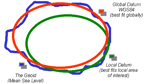
Geodetic Datum in General
The depiction of three-dimensional position
requires a three dimensional surface. A convenient surface to
represent the earth is the geoid. It is the equipotential surface of
the earth’s gravity field that on average coincides with mean sea
level in the open oceans. Due to variations in gravity, the geoid
undulates significantly and a regular mathematical model is required
for the calculations associated with a datum. An appropriate
mathematical model is an ellipsoid (or spheroid). Geodetic datum tend
to use ellipsoids which best represent the geoid in the area of
interest. An example of the spatial relationship between a local
datum, a global datum and the geoid is represented in the following
Figure.
Prior to the development of space based measurement
systems, locally defined geodetic datum were sufficient. However,
satellite positioning systems require a single global geodetic datum
and GPS, GLONASS and other space based measurement techniques have had
some fundamental influences on datum definition and use.
- Satellites move around the centre of mass of the earth and
require a datum which is geocentric.
- Their global nature has meant that what has previously been
considered geodetic science is having increasing importance in day
to day surveying.
- Height from these systems is measured above the ellipsoid which
has required better geoid models.
- There has been a trend to revise local working datum to be more
compatible with measurements from systems such as GPS and GLONASS.
- Their three dimensional nature has led to a need to closely
relate horizontal and vertical datum.
A global datum is based on the Conventional
Terrestrial Reference System (CTRS). An important underlying concept
is that reference systems definitions are purely definitions and must
be realized through some defined process. Three particularly
relevant realizations of the CTRS are WGS84 as used for GPS, PZ90 as
used for GLONASS and the International Terrestrial Reference Frame (ITRF
- see Boucher and Altamimi, 1996). WGS84 and PZ90 are established and
maintained by military organisations while the ITRF is produced by a
scientific institution, the International Earth Rotation Service (IERS).
The World Geodetic System of 1984
The geodetic datum used for GPS is the World
Geodetic System of 1984 (WGS84). The significance of WGS84 comes about
because GPS receivers rely on WGS84. The satellites send their
positions in WGS84 as part of the broadcast signal recorded by the
receivers (the so-called Broadcast Ephemeris) and all calculations
internal to receivers are performed in WGS84.
From a technical point of view, WGS84 is a
particular realization of the CTRS. It is established by the National
Imagery and Mapping Agency (NIMA) of the US Department of Defense (for
original descriptions see DMA, 1991 and Kumar, 1993). The initial
realization of WGS84 relied on Transit System observations and was
only accurate at the one to two metre level. At the start of 1994
(start of GPS Week 730) use of a revised value of the gravitation
constant (GM) along with improved coordinates for the Air Force and
NIMA GPS tracking stations led to WGS84 (G730). That
realization was shown to be consistent with the ITRF at the 10
centimetre level (Malys and Slater, 1994). The improved tracking
station coordinates came from a combined solution using selected IGS
stations (Swift 1994). Further improvements to the tracking station
coordinates in 1996 led to WGS84 (G873). The G873 represent GPS
Week 873 and refers to the date when the new tracking station
coordinates were implemented in the NIMA precise ephemeris process.
The G873 coordinates were implemented in the GPS Operational Control
Segment on 29 January 1997. Tests have shown WGS84 (G873) to be
coincident with the ITRF94 at a level better than 2cm (Malys et al,
1997).
It should also be noted that the ellipsoid used for
WGS84 agrees with that of the Geodetic Reference System of 1980 (GRS80
- Moritz, 1980) except for a very small difference in the flattening
term. GRS80 is the reference ellipsoid associated with ITRF.
Working with WGS84
It should be noted that there are only two ways to
directly produce WGS84 coordinates. The first is by GPS surveying
measurements relative to the US DoD’s GPS tracking stations.
However, the GPS data from those DoD stations is not typically
available to civilians. The second way is by point positioning using a
GPS receiver. However, the accuracy of point positions performed by
civilians is limited by the policy of Selective Availability to +/-
100m at 95% confidence. Only US DoD or allied military agencies can
perform point positioning with centimetre to decimetre accuracy.
Civilian surveyors often require WGS84 coordinates
to an accuracy better than that available from point positioning. For
example, a common requirement for accurate WGS84 coordinates is to
seed the processing of GPS surveying baselines (post-processed or real
time). However as outlined above, civilians cannot access WGS84
directly with high accuracy and must therefore resort to indirect
means to produce WGS84 compatible coordinates.
One way to obtain more accurate WGS84 compatible
coordinates is to use local datum coordinates and a published
transformation process. In practice, a transformation process is
derived between data sets on both datum and any errors in those data
sets affect the transformation process. The quasi WGS84 coordinates
that result from a transformation process can be in error in an
absolute sense by as much as several metres but are usually more
accurate in a relative sense. Transformation processes in common use
include the three parameter Molodensky method (or block shift), seven
parameter (or similarity) transformation, multiple regression
equations and surface fitting approaches (see the FIG Fact Sheet on
Datum Transformation).
The most rigorous way for civilian surveyors to
produce WGS84 compatible coordinates is to perform GPS surveying
measurements relative to control stations with published ITRF
coordinates. That will produce ITRF coordinates for any new stations.
As outlined above, ITRF94 (or later) coordinates can then be claimed
to be within a few centimetres of their WGS84 G873 equivalents.
An important mechanism allowing the ITRF to be
accessible for geodetic networks anywhere in the world is the ability
to access precise ephemeris for the GPS satellites and precise station
coordinates from the International GPS for Geodynamics Service (IGS).
The IGS has a global network of stations with high quality receivers
observing GPS continuously (Zumberger et al 1995).
Given widespread use of GPS, there is a trend for
the working geodetic datum to be consistent with recent ITRF and
therefore with WGS84. This trend was set with the North American Datum
of 1983 as a geocentric datum using the GRS80 ellipsoid. Recent
implementations have taken advantage of the continued development of
the various ITRF (e.g. for European developments see Seeger, 1994).
Australia is also progressing toward adoption of an ITRF based
geocentric datum by the year 2000 (Manning and Harvey, 1994). In such
cases where the modern geodetic datum is based on a recent ITRF it
will be compatible with WGS84 at the few centimetre level.
Relevant Internet Links
WGS84 NIMA Publications - Includes links to a PDF file of "DMA
1991" as referenced above plus other useful WGS84 documents and
software at http://164.214.2.59/geospatial/products/GandG/pubs.html
Geodetic Reference System of 1980 (GRS80) - Moritz, 1980 - Internet
Version at http://www.gfy.ku.dk/~iag/handbook/geodeti.htm
International Terrestrial Reference Frame (ITRF) at http://lareg.ensg.ign.fr/ITRF/
International GPS for Geodynamics Service (IGS) at http://igscb.jpl.nasa.gov/
Other Relevant FIG Fact Sheets
FIG Fact Sheet 5.002 - Datum Transformation
References
Boucher C. and Z. Altamimi, 1996, International Terrestrial
Reference Frame, GPS World, September 1996.
DMA, 1991, Department of Defense World Geodetic System 1984: Its
Definition and Relationship with Local Geodetic Systems, DMA TR
8350.2, second edition, 1 September.
Kumar, M., 1993, World Geodetic System 1984: A Reference Frame for
Global Mapping, Charting and Geodetic Applications, Surveying and Land
Information Systems 1993; Vol. 53 No. 1: pp 53-56.
Malys, S. and J. Slater, 1994, Maintenance and Enhancement of the
World Geodetic System 1984, Presented at The Institute of Navigation,
ION GPS 94, Salt Lake City, Utah, September.
Malys, S., J. Slater, R. Smith, L. Kunz and S. Kenyon, 1997,
Refinements to the World Geodetic System 1984, Presented at The
Institute of Navigation, ION GPS 97, Kansas City, MO, September 16-19.
Manning, J. and B. Harvey, 1994, Status of the Australian
Geocentric Datum, The Australian Surveyor, March.
Moritz H. , 1980, Geodetic Reference System 1980, Bulletin
Geodesique 1980; Vol. 54, No. 3, pp 395-405.
Seeger H., 1994, The New European Reference Datum and its
Relationship to WGS84, FIG XX Congress, Commission 5, Melbourne,
Australia, 5 - 12 March 1994.
Swift E., 1994, Improved WGS84 Coordinates for the DMA and Air
Force GPS Tracking Sites, Presented at The Institute of Navigation,
ION GPS 94, Salt Lake City, Utah, September.
Zumberger J. F., R. Liu and R.E. Neilan, (Editors), 1995,
International GPS for Geodynamics Service 1994 Annual Report, IGS
Central Bureau, Jet Propulsion Laboratory, California Institute of
Technology, Pasadena, California, USA, September.
Appendix 2 - EXAMPLE OF A LOCAL INFORMATION SHEET
International
Federation of Surveyors
Fédération Internationale des Géomètres
Internationale Vereinigung der Vermessungsingenieure
Commission 5: Positioning and Measurement
Working Group 5.5: Reference Frames in Practice
FIG Local Information Sheet 5.501 - Great Britain
Organisation
Great Britain includes England, Scotland and Wales.
It does not include Northern Ireland or the Republic of Ireland. The
national mapping agency, Ordnance Survey Great Britain, is responsible
for national reference frames. Ordnance Survey operates a helpline to
which all enquiries should be directed in the first instance.
Reference frames summary
Historical basis of mapping: All national
mapping is based on the National Grid, which is a Transverse Mercator
projection of the triangulation network OSGB36 observed 1935-1962,
using the Airy 1830 ellipsoid. A different National Grid exists for
Ireland. Heights are shown as orthometric heights relative to Ordnance
Datum Newlyn, a single tide-gauge mean sea level datum observed
1915-1921, and realised by a primary national network of 200
Fundamental levelled bench marks.
GPS reference system: The national standard GPS
reference system is ETRS89, which is obtained by a 6-parameter
transformation of ITRS96 published by IERS. ETRS89 is a WGS84 variant
tied to the stable part of the European plate. It current (1999)
differs from ITRS96 by about 25cm, growing by 2.5cm per year.
National GPS Network: The primary reference
frame for GB since 1992 has been the National GPS Network, including
750 roadside marks with ETRS89 coordinates, observed in 1991-92. In
1999 the National GPS Network is being upgraded by the addition of
about 30 active GPS stations (i.e. continuously observing automatic
stations), such that all points in GB will be within 100km of an
active station (150km in Scottish Highlands). Also, new passive
stations have been added at all Fundamental height benchmarks,
bringing the total passive network to 900 stations. Passive stations
are now re-observed on a 5 year cycle.
Realisation of National Grid: The National Grid
is currently formally realised by the stations and archive coordinates
of the triangulation network OSGB36. The National Grid Transformation
OSTN97 is an interpolated grid of horizontal plane shift parameters
covering GB at 1km resolution, which converts ETRS89 GPS coordinates
to National Grid coordinates with an accuracy of 20cm (RMS). In 2002,
an improved version of this transformation will become the definition
of the National Grid, and use of the triangulation network will be
discouraged.
Realisation of Ordnance Datum Newlyn: The
orthometric height datum is currently formally realised by the
fundamental bench mark network and archive of levelled coordinates.
The National Geoid Model OSGM91 is an interpolated grid of offsets
between the ETRS89 ellipsoid and a gravimetric geoid model aligned to
Ordnance Datum Newlyn. The accuracy of OSGM91 as assessed by GPS/levelling
is better than 10cm (95% confidence). The use of the National GPS
Network and OSGM91 for establishing new orthometric height benchmarks
is encouraged. Reliance on densification benchmarks for orthometric
height control is not recommended.
Product availability
OSTN97 and OSGM91 are licensed to software vendors
for incorporation in GPS, GIS and navigation software packages. A list
of current licensed data distributors is available on the OS Website.
These products are not available direct to users from OS. National GPS
network Passive station coordinates and information are available from
OS Technical Sales. Active station coordinates and GPS data are not
yet available, but are expected to become available via an Internet
server during 1999. Traditional control information (triangulation
stations and height benchmark information) is available from Ordnance
Survey Technical Sales.
Special Issues
The triangulation network OSGB36 contains scale and
orientation distortions causing errors in coordinates at the 5-10
metre level. No simple GPS datum transformation for the whole of GB
can fit National Grid coordinates to better than 5m accuracy. For
precise work, the datum transformation required can change over short
distances. Therefore, Ordnance Survey discourage the use of simple
datum transformations in Great Britain - the national standard
transformation OSTN97, which models OSGB36 distortions at 1km
resolution, should be used.
References
The 'GPS positioning and coordinate systems' page on the OS Website
has links to all the OS information available about Reference Frames
in Great Britain.
The address is: http://www.ordsvy.gov.uk/services/gps-co/index.htm
Papers currently available on this site include:
A Guide to Coordinate Systems in Great Britain - a 42-page booklet
explaining many geodetic concepts and detailing coordinate systems and
reference frames used in GB.
Information Paper 12/1998 - GPS and mapping in the 21st century - a
publicity document outlining current Ordnance Survey geodetic policy.
Improving Access to the National Coordinate Systems
- an article first appearing in Surveying World magazine, giving an
overview of current geodetic developments in Britain to the land
surveying profession.
Professor Paul Cross
Department of Geomatic Engineering
University College London
E-mail: paul.cross@ge.ucl.ac.uk
Web site: http://www.ge.ucl.ac.uk/
Matt Higgins
Department of Natural Resources
E-mail: Matt.Higgins@dnr.qld.gov.au
Web site: http://www.dnr.qld.gov.au/
Roger J. Lott
BP Amoco Exploration
E-mail: lottrj@eu1.bp.com
Web site: http://www.bpamoco
27 March 2000
|