 |
More the 50 experts from more then 20 countries
were invited to join the meeting held in the UN Conference Centre in
Bangkok. 22 papers on the subject were presented and discussed. The
meeting was organised by the FIG Commission 7 on Cadastre and Land
Management, The World Bank, UN-Habitat and the UN Economic and
Social Commission for Asia and the Pacific. |
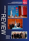 |
The
FIG Annual Review 2003-2005 is available as a .pdf-file from
here. Hard copies will be mailed to all members by the end of June
2005. You can receive your personal copy by contacting the FIG
office, email: FIG@fig.net
|
-
-
-
-
-
Federation des Geometres Francophones has been established in Rabat,
Morocco 24 November 2005
The Presidents of both the French Ordre des Geometres Experts and the
Moroccan Ordre des Ingenieurs Geometres Topographes, on behalf of the follow
up committee consisting of Algeria, Cameroon, Czech Republic, France and
Morocco, invited representatives from about thirty countries to attend the
General Assembly which will create the Federation des Geometres Francophones
(Federation of French-speaking surveyors). This meeting took take place in
Rabat / Morocco on the 24th of November. The countries invited are either
affiliated or associated to the International Organization of Francophony.
For further information, please contact Mr. Rafic Khouri:
r.khouri@geometre-expert.fr
-
FIG Commission 7 and the University of Wisconsin organised together a
Symposium on Innovative Technologies for Land Administration at the
University of Wisconsin, Wisconsin Historical Society, Madison WI, USA, 24 -
25 June 2005. This symposium was combined to the annual meeting of FIG
Commission 7.
-
-
-
-
-
-
-
The FIG Council established in January 2005 a new Task Force on FIG
Governance Structure. The terms of reference of this Task Force were
endorsed by the General Assembly in Cairo where the Task Force also had its
first meeting. The Task force is chaired by Vice President Ken Allred.
This Task Force as also its own
web
site.
-
-
-
-
-
-
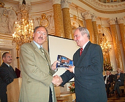 |
On occasion of the 60th anniversary celebrations of the
Polish Head Office of Geodesy and Cartography (GUGIK) on 23 June at the
Royal Castle in Warsaw FIG President Prof. Holger Magel
visited the headquarters of the FIG member association in Poland. A
special highlight was a meeting with representatives of Warsaw geodetic
students association GEOIDA, who invited the President to the
International Geodetic Students Meeting (IGSM) in Krakow next year.
Surveyor General of Poland Jerzy Albin
gets as a gift the copy of FIG annual Review 2003-2005 |
-
FIG Working Week and 8th International Conference of the Global Spatial
Data Infrastructure (GSDI-8) in Cairo, Egypt, 16-21 April 2005 - visit
the web site www.fig.net/cairo
-
Proceedings now available
|
Proceedings now available.
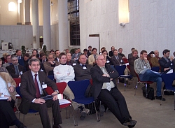
Keynote speakers of the opening ceremony |
FIG Working Week 2005 and the 8th
International Conference of GSDI was held in Cairo from 16 to 21
April 2005. The Organizing Committee consisted of the Egyptian
Committee for Surveying and Mapping (ECSM), and the Egyptian Survey
Authority (ESA), who together with FIG and GSDI were in charge of
the arrangements of this successful and biggest ever FIG Working
Week. The conference was attended by more than 900 participants from
more than 80 countries.
In the conference programme there were more than 400 papers and
poster presentations in more than 50 technical sessions and 7
pre-conference workshops. In addition to opening and closing
ceremonies there were three high profile plenary sessions.
Updated proceedings are available at:
www.fig.net/pub/cairo
, the updates include handouts out those ppt-files that were
submitted in time.
|
|
More information about the conference: |
-
Minutes of the FIG General Assembly in Cairo April 17 and 21, 2005
The FIG General Assembly was held in Cairo, Egypt 17 and 21 April
2005. At the General Assembly following decisions were made:
|
Vote of the FIG 2010 venue. |
- The FIG Congress 2010 will be held in Sydney, Australia
- Andrew Leyzack from Canada was appointed as Chair Elect to
Commission 4 2005-2006 and as chair 2006-2010 and Simon Adcock
from Australia was appointed as Chair Elect to Commission 8 for the
same term of office.
- New member associations were adopted from Botswana, Brunei
Darussalam, Kosovo UNMIK, Mexico and United Arab Emirates. TOPCON
Corp. has joined as a corporate member.
- Jerome Ives from USA was appointed as an honorary member.
Minutes of the General Assembly now available. |
The Board of Directors of the FIG
Foundation decided on the grants for 2005 at its meeting in Cairo. Seven
applicants out of 14 got a grant this year. Grants were given to
following succesful applicants: Parama Anandan (India), Daniel
Paez
(Australia), Ganesh Prasad (Nepal), Karin Viergever
(United Kingdom), Mia Flores-Borquez (United Kingdom),
Emmanuel Tembo
(Botswana) and Hasanuddin Zainal Abidin (Indonesia). Next grants
will be offered in 2006.
-
Request of support to surveyors from Sri Lanka after the tsunami
disaster
The Surveyors' Institute of Sri Lanka has asked support from
international surveyors' society to survey professionals in Sri Lanka.
Several members of the association lost all their belongings and even their
survey equipment got washed away. The institution is asking support for
about ten surveyors at least for them to commence their professional
practice. Please contact the institution by email at
surveyors@eureka.lk to find how
best to help. Letter from the
institution as a .pdf-file. Read the
latest news
from the President of the Surveyors' Institute.
-
-
-
-
-
FIG Council meets in Munich, January 28-29, 2005
 |
The FIG Council met at the Technical University in Munich, January
28-29, 2005. This was the first time when the new Council members Ken
Allred and Stig Enemark attended the Council as well as
Matt Higgins as the ACCO representative. The decisions included
proposals to the General Assembly on membership, finances and the venue
of FIG 2010. The Council also endorsed the Aguascalientes Statement and
decided to establish a Task Force to study the future FIG Commission
structure. |
 |
Workshop on Standardization on the Cadastral Domain
was organised by COST Action G9 and FIG Commission 7 in Bamberg,
Germany 9-10 December 2004.
|
-
-
 |
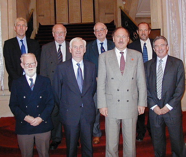
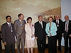
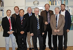
President Holger Magel visited the two FIG
member associations in UK December 2-3, 2004. He gave an evening lecture
at the RICS December 2, and had a meeting with the ICES Board members as
well as with the RICS representatives on December 3. He also met with
the new President of ISPRS, Prof. Ian Dowman.
President Magel together with ICES Board members,
President
Robert Fleming in the middle with Prof. Magel. |
|
|
 |
Workshop on 3D cadastre in Nepal - 3 May 2005
|
Cadastral Survey Branch, Survey Department, Nepal had organized a
successful one day discussion programme on the topic ‘implementing
3D cadastre in Nepal’ at Survey Department Hall, Minbhawan,
Kathmandu, Nepal on 3 May 2005. Thirty five participants from 10
related Government Organizations were participated on that
programme. The participants were mainly senior level executives and
policy makers from different organizations. Different organizations
are involving in Nepal for the data acquisition, data maintenance
and data dissemination about 3D cadastre. The intension of the
programme was to raise awareness to the different organizations for
implementing 3D cadastre to secure the ownership and facilitate the
real estate market.
The history of land recording in Nepal was started from one
dimension (i.e. keeping the record only) and now the registration of
two dimensions (i.e. measuring the length and breadth of the parcel
and calculating area) is in practice. Basically, the legal
boundaries of parcels used for the registration of the legal status
are fixed in 2D space. Due to the high population growth and growing
interest in using space under and above the surface (particularly in
the urban areas) there is a need of registration of vertical
dimension of the legal status of real estate objects. To be able to
define and manage the juridical situation satisfactory, 3D
information are becoming indispensable for land administration in
Nepal.
|
France: Chartered Surveyors Mobilized around a
National Objective: The Creation of a GPS Network of the Territory
by the End of 2005
|
The French Order of Chartered Surveyors (Ordre des Géomètres
Experts )has set itself the objective, by the end of 2005, of
setting up a GNSS (“Global Navigation Satellite System”) network
over the national territory, integrated with satellite
geo-referencing, which will allow any user to position himself in
real time with an accuracy down to the inch, anywhere within the
territory, at any time. Already, 500 chartered surveyors, one third
of the profession, are supporting the rollout of the network—the
most substantial ever carried out in the world at a single time. The
chartered surveyors intend to share this network in order to respond
to the needs of other potential users: in local governments, in
agriculture, public works contractors, network administrators,
vehicle fleets, for housing stock, emergency preparedness,
cartography institutes, research and universities.
|
The European Commission and the United States agreed
on GPS/Galileo co-operation in Brussels in February 2004
|
The United States and the European Commission, joined by the
European Union Member States, held a successful round of
negotiations on GPS/Galileo co-operation in Brussels on 24-25
February 2004. The delegations built upon progress made in The Hague
and in Washington and were able to reach agreement on most of the
overall principles of GPS/Galileo cooperation, including,
- Adoption of a common baseline signal structure for their
respective open services
- Confirmation of a suitable baseline signal structure for the
Galileo Public Regulated Service (PRS)
- A process allowing optimization, either jointly or
individually, of the baseline signal structures in order to
further improve performances
- Confirmation of interoperable time and geodesy standards to
facilitate the joint use of GPS and Galileo
- Non-discrimination in trade in satellite navigation goods and
services
- Commitment to preserve national security capabilities
- Agreement not to restrict use of or access to respective open
services by end-users
- Agreement to jointly finalize associated documents after which
the agreement will be presented for signature
The delegations will continue to work diligently to resolve the
few remaining outstanding issues which concern primarily some legal
and procedural aspects.
|
The Netherlands Society of Geodesy merged into the
new society Geo-Information Netherlands, GIN
|
The Geo-Information Netherlands, GIN was established late last
year and has started under the new structure in January 2004. The
new association is the result of a fusion of in total eight former
societies of landsurveyors, catographers, remote sensing and
photogrammetrists and others.
On October 23, 2003 the landscape of geo-related societies in the
Netherlands changed considerable. Eight societies, among which the
Nederlandse Vereniging voor Geodesie (the Netherlands Society of
Geodesy), merged into the new society Geo-Informatie Nederland
(Geo-Information Netherlands, GIN). The total amount of members is
about 4,000 including 150 institutional members and about 800
academic members. The association is split up into five sections:
- Landsurveying and Geodesy
- Earth Observation
- Cartography and Geo-visualisation
- Real Estate and Landinformation
- Geo-ICT
Every section has a president and is member of the general board.
The new society Geo-Information Netherlands inherited all rights
and obligations of the merged societies including the membership of
FIG. Members of the Nederlandse Vereniging voor Geodesie (the
Netherlands Society of Geodesy) are automatical members of GIN. The
President of GIN is Leen Murre, Secretary is Wilbert
Wouters (ir. W.J.C. Wouters) and the new treasurer is Maarten
Bomers (ir. M.P.H. Bomers). The total number of general board
members is 11 persons.
Contact information:
Geo-Information Netherlands
P.O. Box 57,
NL-5753 CW Deurne,
The Netherlands
Tel. + 31 493 328 628
Fax + 31 493 328 601
E-mail: leen.murre@gbkn.nl
|
UNHCR and UN-Habitat sign a Memorandum of
Understanding - Closing the gap between relief, reconstruction and
development efforts in post-conflict and post-disaster area
|
The High Commissioner, Mr. Ruud Lubbers, and the Executive
Director of the United Nations Human Settlements Programme
(UN-HABITAT), Mrs. Anna Tibaijuka, Under Secretary-General,
signed in the Geneva Headquarters of the United Nations High
Commission for Refugees December 17, 2003 an operational Memorandum
of Understanding opening the opportunity for operational linkages
between the mandates of both organisations.
The significance of this agreement lies in the collaboration
between an agency mandated to address the emergency and humanitarian
obligations of the High Commission, and the developmental and longer
term mandate of the Human Settlements Programme, with a view to
ensuring "...systematic, predictable cooperation between the two
organisations while building on the recognized expertise... of each
organisation." Specific areas of collaboration will include among
others: shelter solutions for refugees and returnees; settlement
planning and management; land and property rights, restitution, and
administration; infrastructure planning and development; and
capacity building of local and national authorities.
The objective of this collaboration however, is to ensure that
one end of the bridge spanning the gap between relief and
development rests within the emergency humanitarian activities of
UNHCR, and the other well into the longer term sustainable human
settlements development activities typically undertaken by
UN-HABITAT.
|
The longest map of the world?
|
In 2004 the Netherlands Committee for Geodesy will celebrate its 125th
birthday. To draw some publicity to this occasion the Netherlands Kadaster
decided to produce a cadastral map 1:2000 of a 332 km. cross section of
the seemless cadastral database of the Netherlands, thus resulting in a
166 m. long map. It is the longest map of the Netherlands and maybe of the
world. A photograph of the map was selected news-photograph of the day by
the largest press agency of the Netherlands. Pictures of the map ("langste
kaart" in Dutch) and a flash-animation can be seen on the website of
Kadaster, www.kadaster.nl.
|
"This is better than learning math" - Made to
Measure
|
Alberta Land Surveyors and the Science Alberta Foundation have launched an
educational math program that has kids saying, "this is better than
learning math" and "this is fun!"
Made to Measure is one of the
newest crates offered as part of Science Alberta's Science in a
Crate program. The crates are a treasure trove of scientific
activities designed to engage minds through hands-on learning. In
the Made to Measure crate, grade eight students get to try their
hand at seven activities commonly performed by Alberta Land
Surveyors. In the "world survey" activity, students draw and
interpret scale diagrams while in the "that was then, this is now"
activity, students estimate areas using
photos and maps of property boundaries.
During the student
testing of the crate, students were heard to say that doing the
activities in the crate were better than doing math. They didn't
realize they were learning about shapes and volumes.
The Made to
Measure crate is based on the grade eight math curriculum and
because the only cost to schools or libraries or community groups
is a small handling charge, it is a great opportunity for those
with limited budgets and resources.
The Made to Measure crate
can be ordered by calling Science Alberta at + 1 403 220 0077 or
visiting their website www.sciencealberta.org.
Thanks to Science Alberta's supporters, users pay just $25 for a
three-week booking, including shipping.
|
|