Working Group - Joint Commission 4 and Young Surveyors Network
Mapping the Plastic
Policy Issues
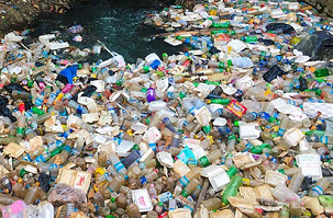
The effects of plastic pollution on the Earth’s oceans are well
documented, potentially catastrophic and increasing exponentially year on
year. The UN Environment Programme has calculated that each year more than
8 million tonnes of plastic ends up in the oceans, wreaking havoc on
marine wildlife, fisheries and tourism, and costing at least $8 billion in
damage to our marine ecosystems. Eighty per cent of all litter in our
oceans is made of plastic. This is an intolerable but not insurmountable
problem that needs immediate and far-reaching action to remedy.
Rivers have been identified as a significant contributor to and enabler
of the plastic pollution problem. Working Group 4.3, a combined initiative
of the FIG Young Surveyors Network and Commission 4, will focus on the
dumping of plastics (and other waste) into major rivers, river systems and
deltas at strategic locations around the world. Waste measurement in these
water bodies using remote sensing, bathymetyric, current measurement and
topographical surveys of plastic waste along the banks of rivers will
enable a greater understanding of the quantum of plastic waste being
transported to the oceans and inform the control and regulation of land
use practices with an ultimate goal of eradicating the dumping of plastics
into river systems.
Chair
Simon Ironside, New Zealand
Specific projects
A pilot project will focus on the Mekong River delta in the south of
Vietnam at its outfall to the South China Sea. This project will be
undertaken in conjuction with The Centre for Supporting Green Development
(GreenHub), a Vietnamese, non-governmental, not-for-profit organisation
and Australia’s Commonwealth Scientific and Industrial Research
Organisation (CSIRO).
What we are working on -
|
 |
What's New
Since it’s inception at the FIG Congress 2018 in Istanbul, Working
Group 4.3, a joint undertaking of Commission 4 and the Young Surveyors
Network, has been very active and there is every indication that it’s
workload will only increase. The effects of plastic pollution on the
Earth’s oceans are well documented, potentially catastrophic and
increasing exponentially year on year. The UN Environment Programme (UNEP)
has calculated that only nine per cent of the nine billion tonnes of
plastic produced throughout the world has been re-cycled and each year
more than 8 million tonnes of plastic come to reside in our oceans. Eighty
per cent of all litter in our oceans is made of plastic. This is an
intolerable problem that needs immediate and far-reaching action to
remedy. Eric Solheim, Head of UN Environment, speaking at the launch of
the #CleanSeas campaign argued that it was past time to tackle the plastic
problem that blights our oceans. ‘We’ve stood by too long as the problem
has gotten worse’ he said, ‘it must stop’. We agree.
Rivers have been identified as a significant contributor to, and
enabler of, the plastic pollution problem affecting our oceans. UNEP
estimates that just ten major river systems carry more than 80% of the
plastic waste that ends up in the Earth’s oceans. Much of the available
information relating to the scale of the plastic pollution problem is
based on relatively crude modelling. Plastic litter is predominantly
concentrated on banks, coastal beaches and in the upper limits of surface
water bodies. The lack of a means of comprehensive analysis of the spatial
and temporal extent and quantum of plastic waste at a specific site, or on
a regional or global level and the tools for ongoing monitoring represents
a significant obstacle to addressing and eradicating the plastic waste
‘explosion’.
Working Group 4.3 has been formed to better understand plastic
pollution in waterways by providing accurate and reliable information of
the magnitude of the problem at source, thereby highlighting unsustainable
practices, identifying infrastructure shortcomings and informing robust
land use controls with the ultimate goal of eradicating the dumping
plastic waste into rivers. As surveyors and spatial professionals, we have
the requisite skills and expertise to determine the vectors, quantum and
frequency of plastic passing through waterways and to accurately quantify
the amount and type of plastic litter on riverbanks, coastlines and
estuarine areas.

Presentation at FIG Working Week 2019 by Britta Denise Hardesty, TJ
Lawson, Qamar Schuyler, Chris Wilcox (Australia),
Trang Nguyen and Hoa Tran (Vietnam): Mapping the Plastic along Hai
Phong's Urban and Coastal Margins (10175)
Remote sensing data from satellites and airborne
platforms available in different spatial, spectral
and temporal resolutions has the potential to be a
reliable source of long-term qualitative and
quantitative information over large geographic
areas. Research by members of the Mapping the
Plastic working group at universities in Bosnia and
Hezegovina and Serbia are currently underway to
distinguish plastics from surrounding litter/debris
classes using remote sensing techniques and the
results are very promising.
Assessment of the spatial extent and variability of plastic is
possible due to the unique spectral signature of polymers in the
near-infrared part of the electromagnetic spectrum and we are looking at
defining the data acquisition technology and identification methodology
that will enable identification of plastic debris down to 1 cm2 in size.
A combination of high resolution satellite and drone data has been
processed using the developed algorithms to detect floating plastic in
surface water, combined with ‘ground truthing’ land surveying
measurements, bathymetric and water current data. This data will enable
teams of volunteers to accurately map plastic concentrations at global
‘hot spots’ to enable regulators to better understand the extent of the
phenomenon they are dealing with and inform decisions that impact the
potential solution.
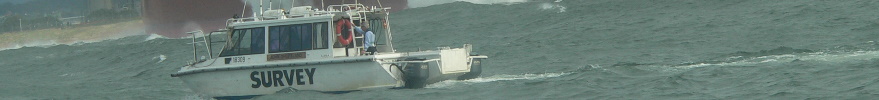
In order to undertake the field work required to infill gaps in the
satellite/drone data, Trimble has kindly donated a suite of surveying
hardware and software to the Mapping the Plastic working group and on
behalf of FIG I would like to express my gratitude to Trimble for their
assistance. This equipment will be of enormous benefit and is greatly
appreciated. Negotiations are ongoing to secure a drone to assist with the
plastic surveys.
|