History of Surveying and
Measurement

|
History of Cadastral Systems
Evolution of Cadastral Systems
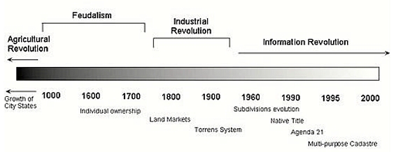
The relationship between humankind and land will always be dynamic (see
Figure 1) [Ting et al., 1998a] and has changed at different rates across
countries and regions as a result of varying pressures and priorities in
society.
Cadastral systems - an Evolving Concept
Download: Cadastral
Systems - an Evolving Concept
"Cadastral systems are the foundation and an integral component of
parcel-based land information systems (LIS) that contain a record of
interests in land. These systems are a central component of the land
administration and land management systems in a state or jurisdiction"
[Williamson, 1990]. This statement shows how far the application of
cadastral systems has evolved.
Land as Wealth and Cadastre as Basic Record and Fiscal Tool
As Grant stated in his paper on territoriality:
"Territoriality is the primary expression of social power. Its
changing function helps us to understand the historical relationship
between society and space. …"
Perhaps, throughout history, one of the strongest drivers for
territoriality and associated expansionist claims is the desire for
commercial growth…." [Grant, 1997].
In the early stages of human settlement, land was undisputedly the
primary source of wealth and power. In that context, cadastre’s primary
function was as a record of ownership and as a fiscal tool. It is
important to note that the point of the record was to provide some
security of ownership as against the world and to do so, required a
record which was publicly acknowledged and respected. Among primitive
tribes, occupation of land had to take place in the presence of the
chief and elders [Larsson, 1996].
The earliest records of land ownership date back to the Royal
Registry of Ancient Egypt that was created in about 3000BC whilst in
China in 700AD the taxation system was based on crop yields and land
survey records [Larsson, 1996]. The Romans carried out a survey in 300AD
to create a register of what lands the Romans controlled as well as
using it as a basis for fiscal records [Larsson, 1996].
The feudal system was extended and developed by the Normans after the
Conquest of England in 1066. All land was owned directly or indirectly
by the king and he granted use of these lands to his subjects (and their
heirs) in return for the rendering of military or other services [Ting
et al., 1998a]. The remnants of that concept lie in the fact that land
in modernday England continues to be classified freehold or leasehold –
both terms describe a form of "tenancy". Karl Marx commented in "The
German Ideology" that:
"The chief form of property during the feudal epoch consisted on the
one hand of landed property with serf labour chained to it, and on the
other of the labour of the individual with small capital commanding the
labour of journeymen" [Arthur, 1974].
Power in the feudal system vested in the institutional and legal
structures that were put in place by the combined interests of
landholders and the sovereign [Davies and Fouracre, 1995]. The Domesday
Book was created after the Norman Conquest to develop a land register
(there were no maps) that stated the owner’s name, tenure, area and
particulars for assessment of the land for the purposes of extracting
feudal dues. In other words, the cadastral register existed for fiscal
purposes and as a record of the territory of the kingdom. Henssen
considered that the philosophy behind the establishment of fiscal
cadastres throughout continental Europe in the early eighteenth century
was the Physiocrat movement which held that land was the basis of all
wealth and therefore land tax would be the basis for raising funds to
maintain society [Henssen, 1975].
Mapping was not common until 1807 when Napoleon Bonaparte established
the foundations of European cadastre when he ordered the creation of
maps and cadastral records. During the Napoleonic era, particular bodies
were given the task of registering transfers and deeds of ownership. The
records showed the physical location of parcels of land as well as
ownership across France, arranged by parcel numbers, area, land use and
land values per owner. It was this combination of registry records and
maps that lay the foundations for modern-day cadastral systems.
Accurate cadastral records were very important for proving ownership
of land that in turn earned people substantial privileges such as
citizenship. The concept of citizenship in the classical period
introduced to Ancient Greece the idea that property ownership should be
linked to citizenship, as defined in its earliest forms by Aristotle and
Plato in the thirteenth and fourteenth centuries [Manville, 1990:94-96].
"It is the ownership of property which confers full citizenship since it
is property which meant that the citizen did not require manual labour
to survive; the propertied citizen could thus devote himself to public
service without the distraction of labour [Turner, 1986:14]. By 500BC,
Emperor Servius Tullius conferred citizenship on the Pleb (unprivileged
aliens domiciled in Rome) [Heater, 1990:16], but implementation was
another matter. Even in the Dutch Republic of the 1700s, the forces of
oligarchy continued to draw a distinction between ‘citizens’ and the
‘populace’ or ‘rabble’[Heater, 1990:29]. The contrary attitude to
linking property and citizenship was not really fully developed until
the twentieth century because prior to that it was generally agreed that
citizens should possess an adequate amount of property to bring on a
tangible stake in maintaining stability [Heater, 1990:167-170].
These basic record and fiscal tool rationales continued to be the
basis for cadastral records until the development of land markets around
the time of the Industrial Revolution.
List of cadastral systems (sorted by countries)
Austria
Finland
|