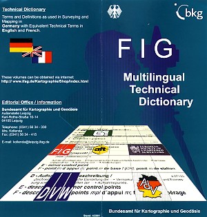
FIG Multilingual Technical Dictionary
Already in 1971 a Dictionary for the surveyors' environment was
published:
"Technical Dictionary -
Terms and Definitions as used in Surveying and Mapping in Germany with
Equivalent Technical Terms in English and French"
Preliminary Edition
Some things never change but some things have changed rapidly.
Progress in science and technology made it necessary to revise the
Preliminary Edition. This huge work started between 1984 and 1990.
The result is something to rely on:
Terms selected by competent technical committees, defined by competent
specialists, English and French terms checked by competent native
speakers.
FIG Multilingual Dictionary
The following organisations stand for the quality of the Dictionary:
- German Association of Surveying (DVW)
- Working Committee of the Surveying Authorities of the Federal
Republic of Germany (AdV)
- The Royal Institution of Chartered Surveyors (RICS)
- Association Française de Topographie (AFT)
- Ordre des Géomètres-Experts (OGE)
- International Federation of Surveyors (FIG).
They created the FIG Multilingual Dictionary
... helping surveyors to communicate.
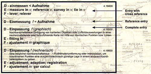
Each volume of the Dictionary contains
- Foreword and Introduction in German, English and French each
- the Dictionary Tern and Definitions as used in Surveying and Mapping
in Germany with Equivalent Technical Terms in English and French
- Register of the equivalent English and French terms.
How does the Dictionary look like?
What's new?
- Vocabulary and definitions are on the level of development of
surveying and mapping at the best beginning of the nineties.
- Quality and number of English and French equivalent terms have
considerably increased as a result of checking by native speakers,
specialists in their fields.
- The number of entries per volume increased by about 30 per cent as
compared to the Preliminary Edition.
Already published as revised edition
Volume 3: Geodetic Surveying
558 entries, DM 16.10 / € 8.23
ISBN 3-88648-059-3
Volume 4: Cadastral Surveying and Cadastre
2nd, supplemented edition, 894 entries, DM 28.90 / € 14.78
ISBN 3-88648-091-7
Volume 5: Geodetic Instruments
974 entries, DM 36.40 / € 18.61
Volume 6: Topography
529 entries, DM 14.50 / € 7.41
Volume 10: Engineering Surveying
381 entries, DM 14.50 / € 7.41
Volume 11: Hydrographic Surveying
381 entries, DM 20.40 / € 10.43
ISBN 3-88648-058-5
Volume 12: Mine Surveying
1309 entries, DM 23.60 / € 12.07
ISBN 3-88648-025-9
Volume 13: Property Valuation
337 entries, DM 11.80 / € 7.67
Volume 14: Land Consolidation
262 entries, DM 11.80 / € 6.03
Volume 15: Urban Planning, Regional Policy
496 entries, DM 17.70 / € 9.05
ISBN 3-88648-057-7
Prices plus post and package!
The following volumes are in preparation
Volume 1: Theory of errors, adjustment methods and mathematical
statistics
Volume 2: Geodesy
Volume 7: Photogrammetry
Volume 8: Cartography
Volume 17: General Terms
Technical Dictionary
Terms and Definitions as used in Surveying and Mapping in Germany with
Equivalent Technical Terms in English and French.
These volumes can be obtained via Internet:
http://www.ifag.de/Kartographie/Shop/index.html
Editorial Office / Information
Bundesamt für Kartographie und Geodäsie
Aussenstelle Leipzig
Karl-Rothe-Strasse 10-14
D-04105 Leipzig
GERMANY
Tel. + 49 341 56 34 -330
Fax + 49 341 56 34 - 415
Email: kollenda@leipzig.ifag.de
FIG Office 14 July 2001 |