Meet the President

|
President Dr. Chryssy A. Potsiou
The FIG General Assembly elected at its
meeting in Kuala Lumpur, Malaysia in June 2014 Dr. Chryssy Potsiou as FIG
President for a four-year term of office 1.1.2015-31.12.2018
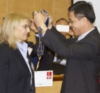
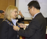
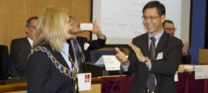
FIG celebrated this transition on 24 January 2015 in
Athens, Greece with a Kick-Off Event and seminar. The main
theme of the seminar was “Ensuring the Rapid Response to
Change, Ensuring the Surveyor of Tomorrow”, which is also the
theme for the current FIG Council 2015-2018. The pictures show
the FIG past president Mr. CheeHai Teo
(2011-2014) handing
over the FIG Chain of office to the new president Dr. Chryssy
Potsiou.
Curriculum Vitae
 |
Dr. Chryssy A. Potsiou
Date of birth: 16 January 1959
Nationality: Greek
Status: Married to Dr Ioannidis Charalabos
Current position: Professor, National Technical University of
Athens
|
Activities
Dr Chryssy Potsiou graduated from the School for
Rural & Surveying Engineering, National Technical University
of Athens (NTUA) in 1982, and was awarded with the Technical
Chamber of Greece (TCG) scholarship for her academic
performance (2nd graduate of the year 1982). She has
received a four-year scholarship from the NTUA to carryout
doctoral studies in the fields of Photogrammetry and
Cadastre. The title of her Ph.D. thesis was “Digital
Cartographic Data for the Hellenic Cadastre”. During her
graduate studies she has worked as teaching assistant in all
classes offered by the NTUA in the fields of Photogrammetry,
Cadastre, and Cartography. Also, during that period, she was
elected as the graduate student representative at the
General Assembly of the School of Rural and Surveying
Engineering. In addition, she has contributed to committees
related to the development of graduate and post-graduate
programmes of that School. Since 1992, she has been employed
as Special Research and Teaching Scientist at the Lab of
Photogrammetry, Topography Division, School for Rural and
Surveying Engineering, NTUA, at a permanent position. At the
same time, she has been working as a consultant in several
research projects (15 of them at the NTUA) in the domains
of:
- aerial photography of archaeological sites
- cadastre and Land Administration
- architectural photogrammetry, detailed photogrammetric
restitutions of complicated monuments, digital
photogrammetric documentation of castles
- cartography and urban planning
- GIS
She was a member of the organizing committees for:
- two scientific meetings organized by the NTUA on the
Hellenic Cadastre (HC) in the years 1986 and 1989
- the International Meeting of Commission VI of ISPRS
for Educational and Financial matters (Rhodes, 1990)
- the International Symposium of CIPA (Delphi, 1991)
- the International Meeting for the HC organized by
HEMCO and FIG Com 7 (Athens, 1996).
- the 2nd Hellenic Congress of the Hellenic Society for
GIS-HellasGI, (Athens 2002)
- the Hellenic Conference on ”GIS on the Go” organized
by the Hellenic Society for GIS-HellasGI, Athens 2003
- the Hellenic Conference for young researchers on
“GIS”, to be organized by the Hellenic Society for
GIS-HellasGI, Athens 2004
- the Hellenic Conference on “Geoinformation Society” ,
to be organized by the Hellenic Society for GIS-HellasGI,
in Athens, March 2004
She was chair of the organizing committee for:
- the FIG Com3 Annual Meeting and Workshop organized in
Athens, 2000
- the UN-FIG joined Workshop on Land Administration to
be held in Athens, in the year 2003
She serves as Secretary General of the LOC for the FIG
Working Week & General Assembly to be held in Athens, in the
year 2004.
In her professional career, she has:
- attended the FIG, ISPRS and C.I.P.A. (for
Architectural Photogrammetry) meetings since 1982.
- attended (MOLA) WPLA and (CERCO) EuroGeographics
meetings since her involvement in the Hellenic Cadastre
Project (1996)
- presented and published 45 papers in various meetings
and journals in the fields of Photogrammetry, Cadastre and
SDI
- given lectures about GIS, Photogrammetry, Cadastre and
Land Administration at the NTUA, the TCG, and the
Technical Chamber of Cyprus.
- been elected as a member of the Council of the
Hellenic Society for Photogrammetry and RS, and served
as Treasurer, for the period 1992-2003.
- Been a member of the FIG Com7 WG for the compilation
of the FIG publication “Cadastre 2014”
- Presented oral national reports at several FIG Com7
and Com3 annual meetings as a delegate and contributed
to their work for several years (questionnaires,
reports, etc)
- Organized two training seminars for unemployed
engineers in Greece, about “Cadastre and SIM” at the
IEKEM, training branch of the Technical Chamber of
Greece, in the years 1998, 1999 (with the participation
of invited international experts from the Kadaster, the
Netherlands)
- been Chair of FIG WG 3.1 “Spatial Information
Management- Technical aspects” for the period 1998-2002
- been National Delegate and member of the TCG
committee, that submitted the bid, in Sun City, for
hosting the FIG General Assembly in Athens in the year
2004.
- been working as management-advisor for educational
and technical issues at the KTIMATOLOGIO S.A., agency
responsible for the implementation of the Hellenic
Cadastre, 1998-end of 2001
- been working part-time, as national delegate, at the
Technical Chamber of Greece, at the International
Relations Office, since 2002
- been elected as member of the UN-ECE-Working Party
for Land Administration Bureau for the period 2001-2003
- made oral presentations at the UN/ECE WPLA and
Committee on Human Settlements meetings and General
Assemblies (2001-2003)
- been Chair of FIG WG 3.3 “State of the Art of SDIs”,
since April 2002, acting also as Vice-Chair of Com3
- been member of the UN/ECE WPLA Task Force for the
compilation of the “Guidelines on Real Property Units
and Identifiers”
- organized a World Bank Training course on “Land
Cadastre and Registration of Rights”, at the NTUA for
Russian Delegates from LARIS (Centre for Land Reform
Implementation Support Project).
She speaks English (Certificate of Proficiency in
English, Cambridge) and German (Mittelstufe, Goethe
Institut).
Scientific papers
- Potsiou, C., Ioannidis, C., Stambouloglou, E.,
Badekas, J., 1982. “Data Processing and Graphical
Representation Systems for Thematic Mapping”, Proceedings
of the Symposium of the Hellenic Photogrammetric Society,
Athens, 22p. (in Greek).
- Ioannidis, C., Potsiou, C., Stambouloglou, E.,
Badekas, J., 1982. “Analytical Restitution with Stereocord
G-2”, Proceedings of C.I.P.A. International Symposium on
‘Photogrammetric Contribution to the Documentation of
Historical Centers and Monuments’, Siena, Italy, pp.
161-171.
- Potsiou, C., Badekas, J., 1985. “Computer Assisted
Photogrammetric Restitution: Analytical Orientations”,
Technika Chronika (Scientific Journal of the Technical
Chamber of Greece), 1985, vol 5, issue 4, p. 187-220 (in
Greek).
- Badekas, J., Georgopoulos, A., Ioannidis, C., Potsiou,
C., 1986. “Analytical Photogrammetry for Archaeological
Surveys”, Proceedings of the Congress “Modern Methods for
Surveying and Documentation of Archaeological Sites and
Monuments”, Center for the Preservation of Cultural
Heritage of “Agios Oros” Monastries, Thessaloniki, p.
609-628 (in Greek).
- Potsiou, C., Badekas, J., 1986. “Perspectives for
Digital Registrations in the Hellenic Cadastre”
Proceedings of the Congress “Perspectives of the Hellenic
Cadastre”, School of Rural and Surveying Engineering,
National Technical University of Athens, Athens, published
by the Technical Chamber of Greece, Athens, p. 425-436 (in
Greek).
- Georgopoulos, A., Ioannidis, C., Potsiou, C., Badekas,
J., 1988. “Photogrammetric wave profile determination”,
Proceedings of ΧVI ISPRS Congress, Commission V, Kyoto,
Japan, International Archives of Photogrammetry and Remote
Sensing, vol. 27, part Β5, pp. 203-212.
- Georgopoulos, A., Ioannidis, C., Potsiou, C., Badekas,
J., 1988. “Analytical approaches to the problem of
architectural restitution”, Proceedings of ΧVI ISPRS
Congress, Commission V, Kyoto, Japan, International
Archives of Photogrammetry and Remote Sensing vol. 27,
part Β11, pp. 370-379V.
- Georgopoulos, A., Dimopoulou, E., Zentelis, P.,
Ioannidis, C., Potsiou, C., 1989. “Organization and
Maintenance of the Cadastre- Comparisons between Cadastral
Systems of various Countries”, Proceedings of the 2nd
Congress “Perspectives of the Hellenic Cadastre”, School
of Rural and Surveying Engineering, National Technical
University of Athens, Athens, Special Edition of the
Technika Chronika 1993, Technical Chamber of Greece,
p.112-118 (in Greek).
- Potsiou, C., Badekas, J., 1989. “Digital Recording for
the Hellenic Cadastre”, Proceedings of the 2nd Congress
“Perspectives of the Hellenic Cadastre”, School of Rural
and Surveying Engineering, National Technical University
of Athens, Athens, Special Edition of the Technika
Chronika 1993, Technical Chamber of Greece, p. 160-167 (in
Greek).
- Ioannidis, C., Potsiou, C., Badekas, J., 1989.
“Surveying Ancient Fortifications of Greece”, Proceedings
of XII C.I.P.A. International Symposium of Architectural
Photogrammetry, Rome, Italy.
- Stambouloglou, E., Badekas, J., Georgopoulos, A.,
Dimopoulou, E., Potsiou, C., Paganis, C., Chliveros, D.,
1989. “Photogrammetric restitution of the Athenian Public
Market“, Proceedings of XII C.I.P.A. International
Symposium of Architectural Photogrammetry, Rome, Italy.
- Badekas, J., Ioannidis, C., Potsiou, C.,
Papathanassopoulos, G., Tsouchlos, N., Vichos, J.,
Kyriakopoulou V., 1990. “Photogrammetric Restitution of an
Ancient Greek Shipwreck”, Proceedings of XIII C.I.P.A.
International Symposium, Cracow, Poland, pp. 41-47.
- Potsiou, C., Ioannidis, C., Badekas, J., 1991.
“Documentation of Castles in a Special G.I.S.”,
Proceedings of C.I.P.A. International Symposium on
‘Αrchitectural Photogrammetry and Information Systems’,
Delphi, pp. 79-91.
- Potsiou, C., Ioannidis, C., Badekas, J., 1992. “A
Special Information System for the Documentation of
Castles”, Proceedings of XVII ISPRS Congress, Commission
V, Washington D.C., U.S.A., International Archives of
Photogrammetry and Remote Sensing vol. 29, part Β5, pp.
287-291.
- Potsiou, C., Ioannidis, C., Badekas, J., 1993.
“Documentation of the Hellenic Castles in a Spatial
Information System”, Proceedings of the Congress
“Terrestrial Photogrammetry and Spatial Information
Systems for the Documentation of the Hellenic Cultural
Heritage” Department of Rural and Surveying Engineering,
Aristoteles University of Thessaloniki, Thessaloniki, p.
161-173 (in Greek).
- Badekas, J., Potsiou, C., Ioannidis, C.,
Papatheodorou, G., Paganis, C., 1993. “Photogrammetric
Restitution of the Bell-tower and the surrounding area of
“Ag. Paraskevi” Byzantine Church in Metsovo”, Proceedings
of the 1st Multidiscipline Congress “The National
Technical University pays back part of the Benefaction to
Metsovo”, Metsovo, University Publications of the National
University of Athens, p. 574-591 (in Greek).
- Potsiou, C., 1995. “An estimation of the volume of
digital information of the Hellenic Cadastre“, Proceedings
of Workshop on ‘Reforms of Cadastre and Land Registration
Systems in Central and Eastern Europe and in Latin
America’, Economic Commission for Europe/ United Nations
(ECE/UN), Seville, Spain.
- Potsiou, C., 1995. “Digital Cartographic Data for the
Hellenic Cadastre” Doctoral Thesis, School of Rural and
Surveying Engineering, National Technical University of
Athens, p.213 (in Greek).
- Potsiou, C., 1995. ”Volume of Cadastral Information”,
Proceedings of the Congress “National Cadastre:
Perspectives- Modern Technological Developments”,
Department of Rural and Surveying Engineering, Aristoteles
University of Thessaloniki, Thessaloniki, Association of
Rural and Surveying Engineers of Northen Greece,
Thessaloniki, p.127-141 (in Greek).
- Potsiou, C., 1996. ”Cost of photogrammetric and
cadastral surveys for the compilation of the Hellenic
Cadastre”, Proceedings of XVIII ISPRS Congress, Commission
VI, Vienna, Austria, International Archives of
Photogrammetry and Remote Sensing vol. 31, part Β6, pp.
123-127.
- Ioannidis, C., Potsiou, C., Badekas, J., 1996. ”3D
Detailed Reconstruction of a Demolished Building by using
Old Photographs”, Proceedings of XVIII ISPRS Congress,
Commission V, Vienna, Austria, International Archives of
Photogrammetry and Remote Sensing vol. 31, part Β5, pp.
16-21.
- Potsiou, C., 1997. ”Highlights of the International
Meeting for the Hellenic Cadastre in June 1996, Athens,
Greece”, Proceedings of the FIG Commission 7 Annual
Meeting and Workshop, Penang, Malaysia.
- Ioannidis, C., Potsiou, C., Badekas, J., 1997. “The
use of contemporary photogrammetric procedures for the
recording and documentation of large monuments and their
graphic representation”, Proceedings of ΧVΙ C.I.P.A.
International Symposium on ‘Photogrammetry in
Αrchitecture, Archaeology and Urban Conservation’,
Goeteborg, Sweden, International Archives of
Photogrammetry and Remote Sensing vol. 31, part 5C1B, pp.
131-140.
- Exintavelonis, J., Kavadas, I., Patas, J., Pentaris,
J., Potsiou, C., Priovolos, G., Skouras, G., Stefanis, E.,
1997. “Hellenic Cadastre: Quality control of the Final
Product“, Proceedings of FIG Commission 3 ‘International
Seminar on G.I.S./L.I.S.’, Thessaloniki, Greece,
pp.127-133.
- Potsiou, C., Ioannidis, C., 1998. “Fiscal and Social
Aspects of the Hellenic Cadastre”, Proceedings of XXI
F.I.G. Congress, Commission 7, Brighton, U.K. 1998, pp.
313-327.
- Ioannidis, C., Potsiou, C., 1999. “Detailed
Restitution and Representation of the Seaward Castle of
Chios”, Proceedings (CD) of XVII CIPA International
Symposium, Recife, Brazil 1999.
- Ioannidis, C., Logothetis, C., Potsiou, C.,
Kiranoudis, C., Christolis, M., Markatos, N., 1999.
“Spatial Information Management for Risk Assessment of
Major Industrial Accidents”, Proceedings (CD) of F.I.G.
Commission 3 Annual Meeting and Seminar on ‘Spatial
Information Management’, Budapest, Hungary.
- Potsiou, C., Ioannidis, C., Logothetis, C., Kostakis,
C., Alafodimos, C., 1999. “Organization of the Practical
Training of Students of Higher Technological Institutes in
Greece by using GIS”, Proceedings of the 1st Hellenic
Congress “ Geographic Information Systems – Capabilities
and Applications, Perspectives and Challenges” Hellenic
Society for GIS-HellasGI, Athens (in Greek).
- Ioannidis, C., Potsiou, C., Soile, S., Badekas, J.,
2000. “Detailed 3D Representation of Archaeological
Sites”, Proceedings of XIX ISPRS Congress, Commission V,
Amsterdam, The Netherlands, International Archives of
Photogrammetry and Remote Sensing vol. 33, part Β5/2, pp.
642-649.
- Potsiou, C., 2000. “National Report: Existing activity
in Geoinformatics and the Need for a NSDI in Greece“,
Presentation at the FIG Commission 3 meeting at FIG
Working Week 2000, Prague, Czech Republic.
- Potsiou, C., Galidakis, N.,
Volakakis, M., Doublidis, P., 2000. “The Hellenic
Cadastral System: Progress and Future Strategy“,
Proceedings of the FIG Commission 3 – WG3.1 International
Workshop on ‘Spatial Information Management – Experiences
and Visions for 21st Century’, Athens, Greece, pp. 339-347
- Potsiou, C., Badekas, J., 2001. “Preliminary analysis
of the Hellenic Cadastral data“, Presentation at the
Technical Conference during the FIG Working Week 2001,
Seoul, Korea,
http://www.fig.net/pub/proceedings/korea/full-papers/papers-index.htm
- Potsiou, C., Ioannidis, C., Muggenhuber, G., 2001.
“NSDI’s classification and comparison between various
National Reports“, Presentation at the Technical
Conference during the FIG Working Week 2001, Seoul, Korea,
http://www.fig.net/pub/proceedings/korea/full-papers/papers-index.htm
- Potsiou, C., Muggenhuber, G., Ioannidis, C., 2001.
“Sharing knowledge in Spatial Information Management“,
Proceedings of the FIG Commission 3 Annual Meeting,
Nairobi, Kenya,
http://www.fig.net/pub/proceedings/nairobi/potsiou-muggenhuber-ioannidis-TS1-2.pdf
- Potsiou, C., Volakakis, M., Doublidis, P., 2001.
“Hellenic Cadastre: State of the art – Experience,
proposals and future strategies“, Computers, Environment
and Urban Systems, 25 (January 2001), pp. 445-476.
- Potsiou, C., Zentelis, P., Labropoulos, T., 2002.
“Mass-valuation in Greece: Monitoring Tax and Market
values“, Proceedings of the UN ECE Working Party on Land
Administration Workshop ‘On Mass Valuation Systems of Land
(Real Estate) for Taxation Purposes’, Moscow, Russian
Federation, pp. 110-119.
- Potsiou, C., 2002. “Spatial Information Management:
Knowledge, Organizations and Tools“, Presentation at XXII
F.I.G. Congress, Commission 3, Washington DC, USA,
http://www.fig.net/pub/fig_2002/Ts3-3/TS3_3_potsiou.pdf
- Potsiou, C., 2002. “Spatial InformationManagement –
International Trends and Experience”, Proceedings of the
2nd Hellenic Congress of the Hellenic Society for
GIS-HellasGI, Athens (in Greek).
- Potsiou, C., Ioannidis, C., 2002. “The necessity for
Nation-wide Public – Public coordination for effective
Land Administration“, Proceedings (CD) of the UN ECE
Working Party on Land Administration Workshop ‘Customers -
Cooperation - Services’, Vienna, Austria.
- Potsiou, C., Labropoulos, T., 2002. “Spatial
Information Management – State of the art Developing the
FIG Com3 WG3.3 Web-Inventory“, Presentation on the FIG
Commission 3 Annual Meeting and International Symposium
‘GIS 2002’, Istanbul, Turkey.
- Ioannidis, C., Potsiou, C.,
Soile, S., 2003. “An integrated Spatial Information System
for the development of the archaeological site of
Mycenae“, Proceedings of ISPRS Commission V Working Group
6 International Workshop on ‘Visualization and Animation
of Reality-based 3D Models’, Tarasp-Vulpera, Switzerland
- Potsiou, C., Labropoulos, T., 2003. “Collection,
standardization, visualization and knowledge sharing of
information about NSDI activity in various countries“,
Proceedings of FIG Working Week 2003 and 125th Anniversary
of FIG ’Still on the frontline’, Paris, France,
http://www.fig.net/pub/fig_2003/TS_13/TS13_3_Potsiou_Labropoulos.pdf
- Potsiou, C., 2003. “The Value
of the UN/ECE “Land Administration Guidelines” and some
considerations for its Upgrading“, Proceedings of the
FIG-UN/EU WPLA Workshop, Athens, Greece
- Ioannidis, C., Xipnitou, M., Potsiou, C., Soile , S.,
2003. “The contribution of modern geometric recording and
visualization methods in the implementation of a new
museum concept“, Proceedings of CIPA XIX International
Symposium, Antalya, Turkey, International Archives of the
Photogrammetry, Remote Sensing and Spatial Information
Sciences, vol. XXXIV-5/C15, pp. 419-424.
- Potsiou, C., Ioannidis, C., 2003. “Low Cost
Technologies and Techniques in Implementing Cadastral and
Spatial Information Management Infrastructure“,
Proceedings of the 2nd FIG Regional Conference
“Urban-Rural Interrelationship for Sustainable
Environment“, Marrakech, Morocco,
http://www.fig.net/pub/morocco/proceedings/TS23/TS23_1_potsiou_ioannidis.pdf
Contacts
Dr. Chryssy Alex. Potsiou
School of Rural & Surveying Engineering
National Technical University of Athens
9 Iroon Polytechniou Str
15780 Athens
GREECE
Tel. + 30 10 7722 688
Mobile phone: + 30 944 710 817
E-mail:
chryssy.potsiou@gmail.com
|


