FIG Commission 8
- Spatial Planning and Development
|
Work Plan 2023-2026
 PDF:
Original Work Plan in -pdf-format
PDF:
Original Work Plan in -pdf-format
VIDEO:
Chair of Commission 8
Kwabena Asiama takes you through the Work Plan
Terms of Reference
- Spatial planning policy, implementation, monitoring and evaluation
- Land policy instrumentation for the implementation of spatial plans
- GIS tooling in spatial planning
- Rural-urban relations and dependencies
- Participatory and inclusive planning processes
- Urbanization patterns and development strategies
- Valuation in spatial planning and land use change
- Sustainable development
Mission statement
Globalisation, in tandem with limited natural resources, has placed
spatial planning and land management activities at the core of overcoming
the global challenges of the day. The mission of commission 8 is to explore
new approaches to spatial planning and governance, in order to balance the
interests of stakeholder in pursuit of sustainable development in the
short-, medium-, and long-term.
General
Food insecurity, changing social and economic demands, rural-urban
divides, changing patterns of urbanisation, digitisation and disruptive
technologies and the need for responsible approaches, among others, have
posed new global challenges, as well as exerting pressure on land use as
well as spatial governance. Spatial planning, development, and governance
are intricately related to land tenure, and land value. Hence, activities,
policies and innovations undertaken in the context of spatial planning and
governance, will influence, or will be influence by land tenure and land
value, the land rights holders, as well as the users. From this angle,
Commission 8 will seek to connect scientists, professionals and
practitioners from the various surveying disciplines and beyond, towards the
responsible development and transfer of spatial planning tools, towards
sustainable development.
These global challenges facing the society at different levels – local,
regional, national, and supra-national, though may be characterised
similarly, however, manifest differently, with differing effects at each
level. Hence the solutions proffered for these problems also have to be
shaped based on the local situation. This means inter-regional knowledge
transfer needs to consider the political, social, economic, environmental
context in both areas. Recent approaches to reaching the 2030 agenda have
seen the transfer of, among others, spatial planning tools and instruments.
The commission aims to provide the forum for scientists, policy developers,
and practitioners in the spatial planning arena to reflect, review, orient,
learn, and look ahead towards to achievement of the 2030 Agenda. These will
be hooked onto the established guidelines and principles relating to
sustainable development as well as spatial and land governance such as the
sustainable development Goals (SDGs), the Voluntary Guidelines on the
Voluntary Guidelines on the Responsible Governance of Tenure of Land,
Fisheries and Forests in the Context of National Food Security (VGGT), Fit
for Purpose Land Administration (FFP), and the participatory and Inclusive
Land Readjustment (PILaR), as well as other FIG, World Bank and FAO
publications.
The push of technological and digital innovations has created the need
for new policy recommendations towards spatial development, as well as their
implementation to meet the increasing global challenges identified. Central
to these innovations is the participatory approaches that create the meeting
point of local knowledge and professional and technical competencies through
dialogues that give a voice to the key stakeholders, including the local
people, professionals, scientists, and government. This will create the
avenue for the responsible implementation of spatial planning instruments
and policies such as land consolidation, land readjustment, compulsory land
acquisition, land banking, pre-emptive rights, among others that have an
effect on land rights towards spatial development. Participation is an
important component of the spatial planning and development to achieve the
buy in of all the major stakeholders.
To reach the goals of the 2023-2026 term, the following will form the
focus of the Commission:
- Exploration of the short-, medium-, and long-term strategies for
responsible knowledge transfer and innovation in the spatial planning
sphere, with respect to the development of spatial planning tools.
- Discuss the processes of land and spatial policy conception,
development, and implementation to support knowledge transfer and
innovation.
- Explore rural-(peri-)urban dependencies and relations and raise
awareness of planning issues for responsible solutions.
- Discuss and extend the impacts of digital transformation in the area
of spatial planning and land management (in collaboration with
Commission 7).
- Investigate the role of valuation of informal and rural settlements
in the development of spatial planning instruments and policies (in
collaboration with Commission 9).
- Investigation of the spatial planning on global challenges and well
as the role of the former in the mitigation of the later.
- Raise awareness of the need for responsible, participatory, and
smart spatial planning decisions towards supporting sustainable social,
economic, and environmental development.
Working Groups
Working Group 8.1 Urban-rural land linkages
Introduction
Urban and rural development, in terms of land issues, affects people in
many ways. In busy cities and markets, people depend on the backward-forward
exchange of agricultural goods to and from rural areas. Transport networks
(including rivers) are crucial for rural residents who want to travel to the
city and for urban residents who want to travel to rural areas. Agricultural
activities, usually found in rural areas, provide leisure and food security
for urban residents. These urban-rural (and their intersecting peri-urban)
functions are intrinsically linked. They are hindered by different, as well
as common, land challenges (Figure 1).
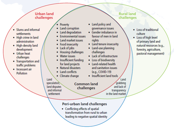
Figure 1 Examples of land problems in urban (including peri-urban)
and rural areas
Efforts to improve their management must ensure that the land they occur
on is secure and that the rights of those who use the land are protected.
Tackling these land-related problems (and leveraging their
interdependencies) requires better coordination of urban-rural land linkages
to achieve balanced urban-rural spatial development. The concept of
urban-rural land linkages (URLLs) and its framework for action emerged in
response to land problems that affect urban and rural areas. It follows the
work of other international institutions, particularly the UN-Habitat, on
bringing together strategies that equally support urban and rural
development.
Policy Issues
-
Investigate how urban policies can consider the values of
neighbouring rural areas for balanced urban-rural development.
-
Probe how to develop and adapt continuum policies against poverty
(through URLLs framework) can provide solutions that work simultaneously
for urban, peri-urban and rural areas.
-
Assess how urban, peri-urban and rural areas can learn from each
other’s spatial planning (and development) experiences.
Chair:
Uchendu Eugene Chigbu
Namibia University of Science and Technology, Namibia.
Email: echigbu[at]nust.na
Co-Chairs
Michael Klaus – Hanns Seidel Foundation, Germany.
Email: klaus[at]hss.de
Jennilee Kohima – Namibia University of Science and
Technology, Namibia.
Email: jkohima[at]nust.na
Specific project(s):
Create URLLs awareness for balanced spatial development and identify
options for attaining equivalent living conditions in urban and rural areas.
Workshop(s):
Special session at GLTN (UN-Habitat) events and FIG working week to
discuss experiences on urban-rural linkages.
Publication(s):
“Urban-Rural Land Linkages: A Concept and Framework for Action”
(UN-Habitat, GLTN, NUST and FIG collaborations). Available:
https://gltn.net/2021/06/22/urban-rural-land-linkages-a-concept-and-framework-for-action/
Timetable:
2024 Deliver a paper on urban-rural land linkages applications (in
collaboration with GLTN, NUST and Hanns-Seidel-Foundation).
Beneficiaries:
United Nations (GLTN), World Bank, FIG Professional Associations (and
member organizations), Land Administrators, Planners, Civil Society
Organizations, NGOs, governments, and Researchers.
Working Group 8.2 Unregistered Land and large-scale acquisition/compensation (Joint Working Group with Commission 9)
Introduction
Unregistered land rights are estimated to account for more than 70% of
land rights in developing countries. Billions of investment dollars for
large scale infrastructure projects are being held up due to a variety of
problems. While international financial institutions such as the World Bank
require compensation payments for recognizable rightsholders, many projects
face difficulties to pay compensation to stakeholders (deemed legitimate or
otherwise) because of complex and unclear regulatory environments that often
surround unregistered lands and technical difficulties to properly valuate
such lands. The problem is further compounded if the land is customarily
used due to unclear boundaries, overlapping claims and political economy
issues. Many projects need to find a way creatively by navigating through
national legal systems to find some space, while also applying pressure on
account of noncompliance. The UN GLTN Valuation of Unregistered Land–A
Practice Manual – Global Land Tool Network (gltn.net) is the first global
and cross profession operational manual to try to help valuers, land
professionals, clients, policy makers and acquiring authorities get to grips
with this complex subject.
Due to the different nature of each phase in the cycle, GIS tools to
support spatial planning practice will require different data
specifications, functionality and usability features. This working group
aims to gain a better understanding of developing useful GIS tools given a
particular planning exercise, based on the different phases in the spatial
planning cycle. Having appropriate and user friendly GIS tools available
will create a positive spin-off in terms of enhancing information
transparency and increase inclusiveness among participating stakeholders.
Policy issues
-
Expansion of the Manual for the Valuation of Unregistered Lands with
case studies.
-
Identification of the effects and influence of non-market values in
compulsory land acquisition and compensation.
-
Transparency of rural and informal land markets
Chair
James Kavanagh, Director Land and Resources, RICS, UK
Email: jkavanagh[at]ics.org
Co-Chairs:
Mike McDermott, International Land Policy, Legal, Institutional and
Valuation consultant, Australia
Email: mikemackd[at]hotmail.com
Peter Wyatt, Department of Real Estate and Planning, Henley Business School,
University of Reading, UK
Email:
p.wyatt[at]henley.reading.ac.uk
Ben Elder, Director Valuation, RICS, IVSC, UK
Email: belder[at]rics.org
Key Players :
Peter Ache and Commission 9.
Specific project(s)
- Non-market value and
its effect on compulsory acquisition and compensation
Workshop(s)
- Joint comm 8 & 9
(I’d also suggest comm 7) at all forthcoming FIG working weeks
- Possible separate
seminar with UN GLTN and/or World Bank
Publication(s)
- Possible FIG
publication on unregistered land valuation, and also an update of the
seminal comm 8/9 publication
No. 54 (fig.net)
Timetable
- Milestones linked
directly to FIG working weeks with final workshop/output Cape Town 2026
Working Group 8.3 – Spatial Planning Instruments and Climate Change (Joint Working Group with the FIG Young Surveyors Network)
Introduction
The role of spatial planning in climate action has been widely
recognized. The challenges resulting from climate change affect as well the
mechanisms of spatial planning, as its tools. Spatial planning addresses
land-related issues either in a normative (land use regulation) or strategic
way (creation of a framework that provides policy guidelines for territorial
development). Mitigation and adaptation to climate change require a
reconsideration of the role and scope of both (land use planning and
strategic spatial planning). The responsible implementation of spatial
planning instruments such as land consolidation, land readjustment,
compulsory land acquisition and land banking, among others, can support
‘mainstreaming’ of climate change actions. WG 8.3 will seek to connect
scientists, professionals, and practitioners towards the transfer of
experiences in implementing adaptive spatial planning tools, that focus on
minimizing potential damage, coping with the consequences of impacts, and
taking advantage of new opportunities.
Policy issues
-
Exchange of knowledge and experiences among experts (policy
developers, practitioners and academia) in adaptive spatial planning
tools
-
Assess how countries and regions can learn from each other’s spatial
planning tools and experiences
-
Reflections on the optimal contributions and impacts of spatial
planning instruments to promote sustainable practices and positive
climate change impacts.
Chair
Adrianna Czarnecka, Department of Spatial Planning and Environmental
Sciences, Faculty of Geodesy and Cartography, Warsaw University of
Technology, Poland
Email: adrianna.czarnecka[at]pw.edu.pl
Wioleta Krupowicz, Department of Spatial Planning and Environmental
Sciences, Faculty of Geodesy and Cartography, Warsaw University of
Technology, Poland
Email: wioleta.krupowicz[at]pw.edu.pl
Charles Etornam Atakora, Geodetic Engineer- Vermessungsbüro Sommerhoff
(Dortmund, Germany)
Email: charlieatakora[at]yahoo.co.uk
Specific project(s)
Workshop(s)
- Webinar on spatial planning instruments and climate change to
exchange knowledge and experiences among experts from different
countries and regions
- Special sessions at FIG working weeks/congress to present and
discuss experiences on implementing adaptive spatial planning tools
Publication(s)
- Possible FIG publication on the role of spatial planning instruments
in climate change mitigation and adaptation
Timetable
- 2024 – organize a webinar on spatial planning instruments and
climate change
- 2026 – organize a special session at FIG Congress at Cape Town
Beneficiaries
- Government agencies with remote or
direct interests, FAO, Planning firms and agencies, general public (to
create and inform awareness of spatial planning instruments and their impact
on climate change)
Working Group 8.4 Digital Transformation for Land Management and Spatial Governance (Joint Working Group with Commission 7)
Introduction
Digitisation, digitalisation and digital transformation are gaining
prominence in policy efforts in many land-related areas around the world, as
outlined in the recent FIG Publication No. 80. In addition to the benefits
of efficiency and cost reduction of intra-sectoral processes, it also
creates opportunities for cross-sectoral synergies that have hardly been
exploited so far. This working group wants to expose best practices from
cross-sectoral digital transformation efforts bridging land administration,
land management, land use planning and spatial governance. It wants to
highlight merits and synergies such as optimal data integration or
interoperability but also explores challenges such as cybersecurity,
capacity issues or alike. As digital developments have different impacts
depending on the region, activities in this working group will pay attention
to the diversity of regions highlighting particularities and ensuring that
the same approach or evaluation scheme should not be applied everywhere.
Policy Issues
-
Digitisation, digitalisation and digital transformation
-
Data Integration and interoperability
-
Regional digital disparities
Chairs
Claudia Stöcker, University of Münster, Germany
(Commission 7)
E-mail: claudia.stoecker[at]uni-muenster.de
Walter Timo de Vries, Technical University of Munich, Germany (Commission
8)
E-mail: wt.de-vries[at]tum.de
Key Players and Collaborators: Rohan Bennett and Commission 7
Specific project(s)
- Science-Policy-Practitioner dialogue discussing topics related to digital
transformation for land management and spatial governance, possibly webinars
focusing on specific regions.
- Possibly collaborate
with cadastral template working group to see “advancements” and efforts of
digital transformation at country level.
Workshop(s)
- Dedicated sessions
at commission meetings and annual FIG working weeks and congress 2023, 2024,
2025 and the XVIII Congress 2026
Publication(s)
- Joint (intermediate)
articles and presentations during FIG events with speakers and experts
- Publication (book)
with inputs from the various working group activities (e.g. webinars,
sessions, dialogues)
Beneficiaries
- FIG Member
Associations as well as other related bodies
Working Group 8.5 Spatial Plan and Valuation Information in LADM Context
Introduction
In 2018, it was decided to review LADM and to extent the scope of LADM
(Lemmen et al., 2021). Even if the Edition I of the standard had a broad
vision, the emphasis was mainly on land registration processes and parcels
of real property. The marine georegulation, valuation information and
spatial plan information were purposely left aside of the scope of the
standard. LADM Edition II is being designed as a multipart standard,
and each part as a standalone standard. Valuation and spatial plan
information are included in (Part 4 and 5, respectively).
LADM Part 4 – Valuation Information is designed using the existing
standard to represent all stages of administrative property valuation,
namely representation of parties involved in valuations, identification of
properties, assessment of properties through single or mass appraisal
procedures, recording transaction prices, generation and representation of
sales statistics, and dealing with appeals. It is expected that the proposed
model in this standard may provide public bodies a common basis for the
development of local and/or national information models and databases,
enabling the integration of valuation databases with land administration
databases, and can act as a guide for the private sector.
LADM Part 5 – Spatial Plan Information aims to provide the general reference
model, as an extension of core LADM (both ISO 19152-1 and 19152-2), for all
objects of spatial planning those covering land/water and below/on/above
surfaces. It provides a conceptual model that represents and documents the
complete view of RRRs from land administration and the spatial planning
processes.
WG 8.5 will seek to connect scientists, professionals, and practitioners
for:
- supporting the development of LADM Part 4 and Part 5,
- investigating the relationships between spatial plan and valuation
information,
- searching a way for the possible integration of Social Tenure Domain
Model (STDM) with spatial plan and valuation information and so on.
Policy Issues
-
Supporting the development of LADM Part 5 – Spatial Plan Information
and also Part 4 – Valuation Information.
-
Investigating the relationships between spatial plan and valuation
information.
-
Searching how to integrate STDM with spatial plan and valuation
information.
-
Supporting the implementation SDGs: LADM allows the implementation of
relevant parts of international guiding documents such as the New Urban
Agenda (UN, 2017), the Voluntary Guidelines on the Responsible
Governance of Tenure of Land, Fisheries and Forests in the Context of
National Food Security (FAO, 2012), the Continuum of Land Rights
(UN-Habitat, 2008), the Fit-for-purpose land administration: guiding
principles for country implementation (FIG/World Bank, 2014) and the
Framework for Effective Land Administration (UN GGIM, 2020). All those
fit well into the context of implementation of the Sustainable
Developments Goals (SDGs).
-
Exploring an active collaboration among the members of the WG,
especially with the joint working group (Com. 3 and Com. 7) on ‘LADM and
3D LA’, and Com. 9.
Chair:
Abdullah Kara, TU Delft, The Netherlands
Email: a.kara[at]tudelft.nl
Co-Chairs:
Prof Peter van Oosterom, TU Delft, The Netherlands
Email:
p.j.m.vanoosterom{at]tudelft.nl
Prof Christiaan Lemmen, ITC, Twente University, The Netherlands
Email: c.h.j.lemmen[at]utwente.nl
Specific project(s)
- Revision of the ISO19152: 2012 Land
Administration Domain Model (LADM) together with ISO TC211, and LADM/3D LA
joint working group (Com. 3 + Com. 7)
- Several PhD research projects on-going at
the various involved universities.
Workshop(s)
- 9th International FIG Workshop on 3D Land
Administration and LADM, 11-13 October 2023, Gavle, Sweden (together with
LADM/3D LA joint working group).
- 10th International FIG Workshop on LADM and
3D LA, Fall 2024, Kuching city, Sarawak state, Malaysia (together with
LADM/3D LA joint working group).
- During FIG WW/ Congress 2024 & 2025 maybe
specific sessions together with LADM/3D LA - tbd
For all workshops and publications the proceedings and papers are uploaded
and maintained into 2 repositories, where also the archives of the
literature on 3D and LADM is maintained (maybe those repositories will be
merged into one -tbd):
http://www.gdmc.nl/3dcadastres/literature/ &
https://wiki.tudelft.nl/bin/view/Research/ISO19152/LadmPublications
Publication(s)
The planned publications for the next four years, resulting from the
activities of WG 8.5, are the following:
- Expected to be published in 2023: Special
Issue ‘Broadening 3D Land Administration’, Land Use Policy (LUP). Peter van
Oosterom, Alias Abduhl Rahman, Eftychia Kalogianni, Mila Koeva (Editors),
- Expected to be published in 2024-2025:
Second Special Issue on LADM revision and initial experiences at a
peer-reviewed journal.
Timetable
- The timetable for the various part of LADM
is:
- Parts 1 (Generic Conceptual Model) and 3
(Marine Georegulation) are expected to become an international standard by
the end of 2023.
- Parts 2 (Land Registration), 4 (Valuation
Information) and 5 (Spatial Plan Information) are expected to become an
international standard by the middle / end of 2024.
- Part 6 (Implementation) has yet to be
started with lead role for OGC and industry (and input from FIG) with a New
Work Item proposal middle 2023, hopefully resulting in an international
standard by the end 2025/start 2026.
- The timetable for the workshops and
specific LADM/3D LA sessions at FIG WW/ Congress 2023, 2024, 2025 and 2026
is indicated above.
Beneficiaries
- Governmental organisations responsible for
land administration and cadastral registration, spatial planning, property
valuation at various levels in government, ranging from national level to
municipalities and all may be even levels above (UN, EU, Worldbank) or below
(towns, neighbourhoods).
- Industry developing and supporting land
administration (components: tools, software, data, services) in areas such
as surveying, planning, valuing, mapping, data management, updating/editing,
dissemination, and visualization.
- International
Academic Association on Planning, Law, and Property Rights (PLPR),
Association of European Schools of Planning (AESOP), International Society
of City and Regional Planners (ISOCARP)) and professionals with research
interest, education program and activities in the fields of:
- Land Administration and Cadastre
- Spatial planning
- Taxation and valuation
- Standardisation activities in those fields
at international (ISO19152 LADM, ISO16950, ISO 16739-1 IFC, etc.), European
(CEN-CENELEC-ETSI SF-SSCC, etc.), national level
- SDGs and land administration.
Co-operation with Other Commissions and
organisations
The Commission intends cooperating with Commissions 7 and 9 as well as the
Young Surveyors Network. Each commission in the partnership will contribute
to the topic from the perspectives, knowledge, and expertise. Commission 8
will contribute to these topics from the spatial planning perspective. The
joint working groups will also be jointly chaired by the respective
commissions. In line with Commission 8’s active support to active
involvement of the FIG Young Surveyors into commission work, a joint working
group (WG 8.3) has been formed with the network.
Co-operation with United Nation Organisations,
Sister Associations and other Partners
Commission 8 will use opportunities to work together with relevant
organisations and networks in the field of spatial planning. Relevant
networks, such as AESOP (Association of European Schools of Planning), and
in particular their thematic group Planning Law and Property Rights (PLPR),
Food and Agriculture Organisation (FAO), LANDac, GLTN or UN-Habitat will be
engaged in the roll out of the commission’s activities. Activities may
relate to publications, projects, or otherwise.
Commission Officers
Commission Chair
Dr. Kwabena Obeng Asiama
Kwame Nkrumah University of Science and Technology (KNUST),
Kumasi, Ghana.
Tel. +233-24-274-6415
Email:
kwabena.asiama[at]knust.edu.gh; commission8[atfig.net
Vice Chair of Administration
TBC
Chair of Working Group 8.1
Prof. Uchendu Eugene Chigbu,
Namibia University of Science and Technology,
Namibia.
Email: echigbu[atnust.na
Chair of Working Group 8.2
James Kavanagh,
Director Land and Resources,
RICS, UK
Email: jkavanagh[atrics.org
Chair of Working Group 8.3
Adrianna Czarnecka,
Department of Spatial Planning and Environmental Sciences,
Faculty of Geodesy and Cartography,
Warsaw University of Technology, Poland
Email:
adrianna.czarnecka[atpw.edu.pl
Chair of Working Group 8.4
Prof. Dr. Ir. Walter Timo de Vries,
Technical University of Munich,
Munich, Germany.
E-mail: wt.de-vries[attum.de
Chair of Working Group 8.5
Abdullah Kara, MSc.
Technical University of Delft,
Delft, The Netherlands,
Email: a.kara[attudelft.nl
Kwabena Obeng Asiama
Chair, FIG Commission 8
www.fig.net/commission8
Email: commission8@fig.net
| |
Chair
of Commission 8
Kwabena
Asiama
commission8[at]fig.net |
|
|


