FIG PUBLICATION NO. 52
The Social Tenure Domain Model
A Pro-Poor Land Tool
Christiaan Lemmen

INTERNATIONAL FEDERATION
OF SURVEYORS (FIG) |

UNITED NATIONS HUMAN SETTLEMENTS
PROGRAMME (UN-HABITAT) |

GLOBAL LAND TOOL NETWORK
(GLTN) |
This publication in other languages (pdf):
Contents
Foreword
1. Introduction
2. The Need for STDM: Identifying the Gap
3. The STDM Tool: Closing the Gap
4. The Benefit of STDM: Support in Sustainable
Development
5. The Use: Simple Approach, Unconventional
Transactions
6. The Process: Developing the STDM
Further Reading
Orders for printed copies
Most developing countries have less than 30 percent cadastral coverage.
This means that over 70 percent of the land in many countries is generally
outside the land register. This has caused enormous problems for example in
cities, where over one billion people live in slums without proper water,
sanitation, community facilities, security of tenure or quality of life.
This has also caused problems for countries with regard to food security and
rural land management issues.
The Global Land Tool Network (GLTN), facilitated by UN-HABITAT and funded by
Norway and Sweden, is a coalition of international partners, including FIG (the
International Federation of Surveyors), ITC (University of Twente, Faculty of
Geo-information Science and Earth Observation, The Netherlands), and the World
Bank (WB), has taken up this challenge and is supporting the development of
pro-poor land management tools, to address the technical gaps associated with
unregistered land, the upgrading of slums, and urban and rural land management.
The security of tenure of people in these areas relies on forms of tenure
different from individual free hold. Most off register rights and claims are
based on social tenures. GLTN partners support a continuum of land rights, which
include rights that are documented as well as undocumented, from individuals and
groups, from pastoralist, and in slums which are legal as well as illegal and
informal.
This range of rights generally cannot be described relative to a parcel, and
therefore new forms of spatial units are needed. A model has been developed to
accommodate these social tenures, termed the Social Tenure Domain Model (STDM).
A first prototype of STDM is available. This is a pro-poor land information
management system that can be used to support the land administration of the
poor in urban and rural areas, which can also be linked to the cadastral system
in order that all information can be integrated.
The chair of Working Group 7.1 of Commission 7 on Cadastre and Land
Management, Christiaan Lemmen, took the lead from 2002 onwards, in the
development of the STDM in close co-operation with UN-HABITAT. ITC, financially
supported by the GLTN, developed a first prototype of STDM, that is supported by
WB.
This FIG Report presents the need for STDM, the properties of STDM as a tool,
and the benefit and use of STDM as a key means of meeting the Millennium
Development Goals (MDGs).
Prof. Stig Enemark
FIG President |
Dr. Clarissa Augustinus
Chief, Land and Tenure Section
Global Division, UN-HABITAT |
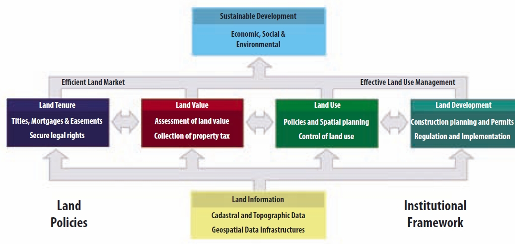
1. Introduction
Land Administration Systems (LAS) provide the infrastructure for
implementation of land polices and land management strategies in support of
sustainable development. The infrastructure includes institutional arrangements,
a legal framework, processes, standards, land information, management and
dissemination systems, and technologies required to support allocation, land
markets, valuation, control of use, and development of interests in land.
In many countries such infrastructure is not available with a nationwide
coverage. In fact this is the case in only 25 to 30 countries worldwide. Further
it can be observed that existing LAS have limitations because of the fact that
informal and customary tenures cannot be included in these registrations.
Generally, the Land Administration Systems are not designed for this purpose.
Existing LAS require extensions to include all existing types of tenures. But
the need for this is not always recognised and institutional changes are not so
easy to implement.
The Social Tenure Domain Model (STDM) could close this gap: STDM allows for
the recordation of all possible types of tenures; STDM enables to show what can
be observed on the ground in terms of tenure as agreed within local communities.
This agreement counts as evidence from the field.
People, living in informal area’s in developing countries, who are visited by
someone with an enlarged satellite image or aerial photo in his or her hands
will give attention to this image or photo. The visitor will be surrounded by
many people almost immediately.
People really understand what they see on the image. They can identify the
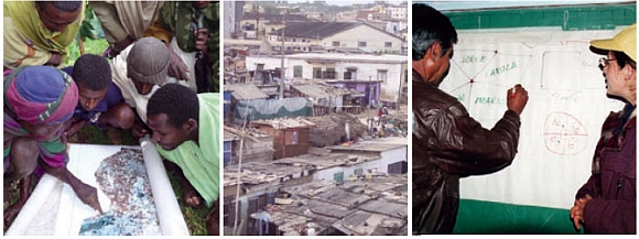
place where they live, and where their neighbours live. See Figure 1.
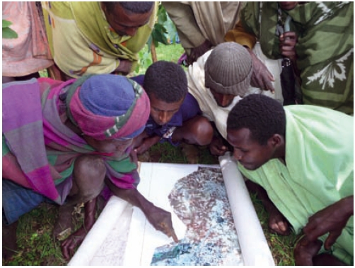
Figure 1: Satellite imagery as basis for data collection. People
recognise immediately the roads and spatial units on the images. High resolution
images can be enlarged and printed with overlaps with ‘neighbour prints’. Based
on the identification of boundaries on the images the boundaries can be drawn on
the image. © Christiaan Lemmen
Surveyors as land professionals are needed in support and management of this
type of data acquisition of ‘people – land’ relationships. This is asking for
widening the scope in relation to land administration; apart from traditional
field surveys related to formal tenure there can be a context as described for
informal tenures. Surveyors understand that there can be differences in spatial
accuracies resulting in different accuracy quality labels. Surveyors can not
only provide accurate maps but they also know how accurate the map is or should
be for the purpose. And surveyors have experience in land administration based
on observations on site.
UN-HABITAT, with support of FIG and WB, developed STDM into a first
prototype, based on an open source database with open GIS software, in close
cooperation with ITC. FIG and UN-HABITAT are involved in the development of an
ISO-standard for a land administration domain model (LADM), including the STDM1).
As soon as this ISO-standard is available it can be used by open source
communities and by commercial software integrators to develop Land
Administration Systems. The ISO-standard can be adapted and extended for local
purposes and avoids reinventing the wheel.
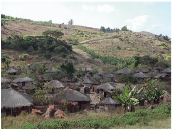
Customary tenure areas are normally outside the formal land registration system.
Malawi. © Stig Enemark
1) The LADM is under development within the Technical
Committee 211 (TC211) of the International Organization for Standardization
(ISO) and identified as ISO 19152. FIG took the initiative for this standardised
domain model for the Land Administration Domain. UN-HABITAT is involved in this
development. This International standard is expected to be available in 2011.
2. The Need for STDM: Identifying the Gap
There is a gap in conventional land administration systems: customary
and informal tenure cannot be handled. There is a need for unconventional
approaches in land administration.
Where there is little land information, there is little or no land
management. Conventional Land Administration Systems are based on the ‘parcel
approach’ as applied in the developed world and implemented in developing
countries in colonial times. A more flexible system is needed for identifying
the various kinds of land tenure in informal settlements or in customary areas.
Traditional land surveys are costly and time consuming. For this reason
alternatives are needed; e.g. boundary surveys based on handheld GPS
observations, or by drawing boundaries on satellite images. This means of course
a different accuracy of co-ordinates. Surveyors understand this and surveyors
are needed to provide quality labels and to improve the quality of co-ordinates
at a later moment in time.
The need for a complete coverage of all land by LAS is urgent. Not only for
the registration of formal rights and for the recordation of informal and
customary rights. Also for managing the value, the use of land and land
development plans. This relates to Enemark’s model on the global land management
perspective; see Figure 2. Complete coverage of all land in a Land
Administration is only possible with an extendable and flexible model, that
enables inclusion of all land and all people within the four land administration
functions. So STDM will close part of the technical gap in developing countries
in terms of making Land Administration covering the total territory.
Impact of disasters, like the 2010 earth quake in Haiti, are difficult to
manage because it is not clear which lands are available for people to be
temporally resettled in tents. After the 2004 tsunami there was land grabbing
where owners had passed away. It is also known that children of parents having
aids lost their living place after parents had passed away.
It is astonishing that interventions in the daily life of communities by
mining industries, by mega farming, or by deforestation are awarded by
governments with land titles, while the rights of local communities are not
recognised. At the same time local communities discriminate women, where access
to land is concerned, in contradiction to national land policies. Given today’s
problems related to urbanisation, environment, access to land, and access to
food and water there is a need to get a complete overview of who is living
where, under which tenure conditions, and for which areas. Overlapping claims to
land need to be included as well as Illegal acquisition or occupation of land. A
complete map of ‘people – land’ relationships is needed.
Such a more flexible extension of LAS should be based on a global standard
and should be manageable by local communities them self from the start.
Standardisation allows for integration of data collected by communities into
formal LAS at a later moment in time.
It should not be misunderstood that formal land titling is important and
necessary, but it is not enough on its own to deliver security of tenure to the
majority of citizens in most developing counties. Customary tenure and informal
settlement tenure have a very strong influence. Individual land titling often
works against the needs and aspirations of poor people, also because of its
cost. Rich landholders are often against land titling because it will visualise
the areas which may be grabbed. Or they may be interested in which areas are not
in the official system, thereby knowing which areas are available for land
grabbing.
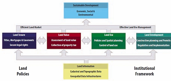
Land administration comprises an extensive range of systems and
processes to manage:
- Land tenure: the allocation and security of rights in
lands; the legal or informal surveys to determine boundaries of
spatial units; the transfer of formal or informal rights or use
from one party to another through sale or lease; and the
management and adjudication of doubts and disputes regarding
social tenure relationships and boundaries.
- Land value: the assessment of the value of land and
properties; the gathering of revenues through taxation; and the
management and adjudication of land valuation and taxation
disputes.
- Land use: the control of land use through the
adoption of planning policies and land use regulations at
national, regional and local levels; the enforcement of land use
regulations; and the management and adjudication of land use
conflicts.
- Land development: the building of new physical
infrastructure; the implementation of construction planning and
change of land use through planning permission and the granting
of permits.
Inevitably, all four functions are interrelated. The
interrelations appear because the conceptual, economic, and physical
uses of land and properties serve as an influence on land values.
Land values are also influenced by the possible future use of land
determined through zoning, land-use planning regulations, and
permitgranting processes. And land-use planning and policies will,
of course, determine and regulate future land development.
Land information should be organized to combine cadastral and
topographic data and to link the built environment (including legal
and social land rights) with the natural environment (including
topographical, environmental, and natural resource issues).
(Williamson, Enemark, Wallace, Rajabifard, 2010) |
Figure 2:
Land Administration Systems provide the infrastructure for
implementation of land polices and land management strategies in support of
sustainable development.
In many countries the land rights of people and legal entities are documented
in a land register and the parcels and their boundaries are recorded in a
cadastre. Sometimes those organisations are under one umbrella. Conveyancers and
land surveyors are in support of adjudication and maintenance processes. Mostly
there is no ‘one-stop-shop’ service in transactions of land rights. Citizens
have to compensate costs for transactions which often lead to corruption. This
makes land administration not a popular activity in many countries. People
should have the confidence that land administration is their
land administration, in support of their own development.
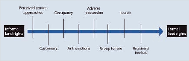
UN-HABITAT proposed the ‘continuum of land rights approach’ in 2003 and this
was further developed and adopted by the Global Land Tool Network partners. An
example of the continuum is given in Figure 3.
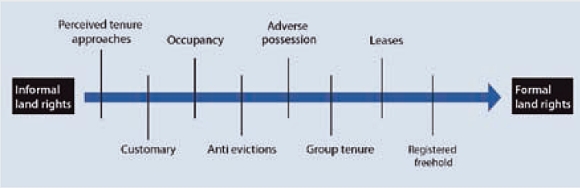
The continuum of tenure types is a range of possible forms of tenure
which can be considered as a continuum. Each continuum provides
different sets of rights and degrees of security and responsibility.
Each enables different degrees of enforcement. Across a continuum,
different tenure systems may operate, and plots or dwellings within a
settlement may change in status, for instance if informal settlers are
granted titles or leases. Informal and customary tenure systems may
retain a sense of legitimacy after being replaced officially by
statutory systems, particularly where new systems and laws prove slow to
respond to increased or changing needs. Under these circumstances, and
where official mechanisms deny the poor legal access to land, people
tend to opt for informal and/or customary arrangements to access land in
areas that would otherwise be unaffordable or not available
(UN-HABITAT:2008). |
Figure 3: GLTNs Continuum of Land Rights.
In conclusion there is an urgent need to have a land information system that
works differently and in addition to the conventional land information system.
Land tenure types, which are not based on formal cadastral parcels and which are
not registered, require new forms of land administration systems.
3. The STDM Tool: Closing the Gap
The concept of STDM is closing the gap, a standard for flexible ‘people
– land’ relationships.
The Social Tenure Domain Model (STDM) is basically about people. It is about
all people and all types of ‘people – land’ relationships. How can informal
settlements be “illegal settlings”? People depend on land for living. Every
human being needs a place – a safe place.
The STDM is an initiative of UN-HABITAT to support pro-poor land
administration. STDM is meant specifically for developing countries, countries
with very little cadastral coverage in urban areas with slums, or in rural
customary areas. It is also meant for post conflict areas. The focus of STDM is
on all relationships between people and land, independently from the level of
formalization, or legality of those relationships.
The STDM is under development as an ISO-standard as a so called
“specialisation” of the Land Administration Domain Model (LADM). The word
“specialisation” means that there are some differences in terminology: what a
“real estate right” is in a formal system is considered as a “social tenure
relationship” in STDM. Note that a formal right is also a social tenure
relationship, but not all social tenure relationships are formal land rights.
‘People – land’ relationships can be expressed in terms of persons (or
parties) having social tenure relationships to spatial units.
Parties are persons, or groups of persons, or non natural persons,
that compose an identifiable single entity. A non natural person may be a tribe,
a family, a village, a company, a municipality, the state, a farmers´
cooperation, or a church community. This list may be extended, and it can be
adapted to local situations, based on community needs.
Land rights may be formal ownership, apartment right, usufruct, free
hold, lease hold, or state land. It can also be social tenure relationships like
occupation, tenancy, nonformal and informal rights, customary rights (which can
be of many different types with specific names), indigenous rights, and
possession. There may be overlapping claims, disagreement and conflict
situations. There may be uncontrolled privatisation. Again, this is an
extensible list to be filled in with local tenancies. A restriction is a
formal or informal entitlement to refrain from doing something; e.g. it is not
allowed to have ownership in indigenous areas. Or it may be a servitude or
mortgage as a restriction to the ownership right. There may be a temporal
dimension, e.g. in case of nomadic behaviour when pastoralist cross the land
depending on the season. This temporal dimension has sometimes a fuzzy nature,
e.g. ”just after the end of the rainy season”.
Spatial units are the areas of land (or water) where the rights and
social tenure relationships apply. According to the LADM/STDM ISO-standard those
areas can be represented as a text (“from this tree to that river”), as a single
point, as a set of unstructured lines, as a surface, or even as a 3D volume.
This range of spatial unit representation can cover community based land
administration systems, or rural, or urban, or other types of land
administrations, like marine cadastres and 3D cadastres. Surveys may concern the
identification of spatial units on a photograph, an image or a topographic map.
There may be sketch maps drawn up locally. A sketch map may be drawn on a wall
where a photograph is taken from.
See Figure 4 for the core – parties, social tenure relationships and spatial
units – of the STDM.
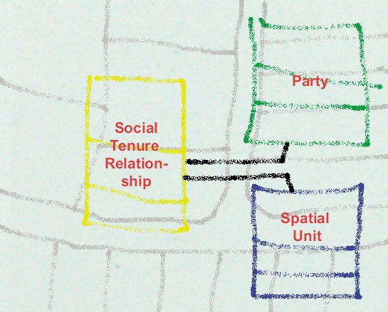
Figure 4: The core of the STDM: parties (tribes, people, villages,
co-operations, organisations, governments), social tenure relations (‘people –
land’ relationships, which can be formal, informal, customary or even conflict),
and spatial units (representations from reality where the social tenure occurs,
can be represented as sketch based, point based, line based, polygon based).
In conclusion, the flexibility of STDM is in the recognition that parties,
spatial units and social tenure relationships may appear in many ways, depending
on local tradition, culture, religion and behaviour. Recordation in STDM may not
only be based on formal registration of formal land rights, but may also be
based on observations in reality, resulting in recordation of informal land use
rights. This is also one of the principles of FIG’s ‘Cadastre 2014’.
4. The Benefit of STDM: Support in Sustainable
Development
The provision of land information in all areas and for all citizens
will support in poverty eradication.
Hernando de Soto states that “civilised living in market economies is not
simply due to greater prosperity but to the order that formalised property
rights bring”. If the world’s community is sincerely of the opinion that
appropriate land administration systems are required for the eradication of
poverty, sustainable development and economic development, then it will be
evident that attention should be devoted primarily to the land administration
systems of developing countries.
Until today most countries (or states, or provinces) have developed their own
LAS. Some countries operate a deeds registration, while others operate a title
registration. Some systems are centralized, and others decentralized. Some
systems are based on a general boundaries approach, others on fixed boundaries.
Some LAS have a fiscal background, others a legal one.
STDM can contribute to sustainable development by the provision of a
flexible, unconventional land administration. This can be seen as an extension
to existing LAS. This may have a start in community based mapping processes,
supporting the mapping of land and property rights. Often local communities lack
knowledge on land laws and areas where those communities are living are not
administered. Many organisations have attention to this issue and there are
networks like the ‘indigenous mapping network’, established by anthropologists.
Also slum mapping in relation to tenure is an issue of international attention.
Depending on the local situation, different registrations or recordings of
land rights are possible. In rural areas there can be spatial units covering
customary areas. Those spatial units can be recorded as ‘text based’ spatial
units, where boundaries are described in words. Or as ‘line based’ spatial
units, drawn on low accurate satellite images; see Figure 5. The tribe may be
represented by its chief. Formal property based spatial units can concern
formally registered ownership with related owner and with identified boundaries
by accurate field surveys. Persons living in ‘structures’ in slum areas may be
identified by fingerprints; see Figure 6. The social tenure relationship to the
spatial units may be represented by points collected with hand-held GPS
instruments – source documents may be printed from websites providing spatial
data. Spatial units in urban business districts can be conventional parcels with
high accurate boundaries. Spatial units in residential areas can be derived from
aerial photographs. If all data are collected in the same structure (Party –
Social Tenure Relationship – Spatial Unit) then the integration with a formal
LAS is possible.
The STDM approach will open up new markets to the land industry and it will
also be an opportunity to develop new skills and to improve management skills.
STDM can make it possible for all citizens to be covered by some form of LAS,
including the poor, thereby improving the land management capacity of the land
industry, as well as addressing upcoming challenges such as climate change.
Also, STDM can contribute to poverty reduction, as the land rights and claims of
the poor are brought into the formal system over time. It will improve their
security of tenure, increase conflict resolution, limit forced evictions, and
help the poor to engage with the land industry in undertaking land management
such as city wide slum upgrading or rural land management.
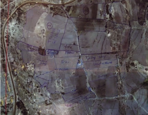
Figure 5: Collected data on top of a satellite image, drawn with pen.
Paper with sufficient quality is needed for use in the field: dust, sunshine and
water… and: many hands holding the paper.
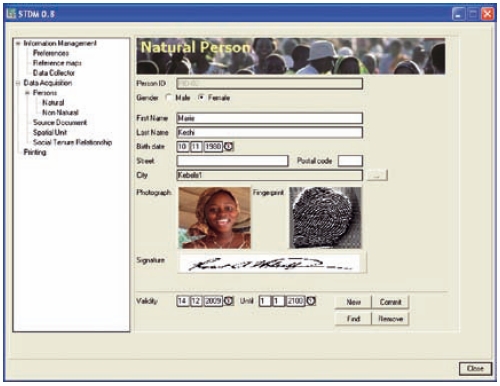
Figure 6. Screendump STDM prototype software. An example where a
fingerprint and a photo of a land user are represented in the user interface.
This person can be related to spatial units (e.g. a single point) via social
tenure relations.
5. The Use: Simple Approach, Unconventional
Transactions
Mindset – this is an invitation not to start saying why the STDM
implementation is impossible because of existing legislation or because of
existing institutional settings. No, it is an invitation to start thinking how
STDM could be implemented to represent all ‘people – land’ relationships, which
can be observed in a community. Starting as a community based land information
system, that can be linked with, and eventually incorporated into a formal
system in the future.
The fact has to be accepted, that more social tenure relationships exist than
statutory land rights, especially at the political and higher administrative
levels. This is best expressed by inclusion in a land policy. The relevant land
agencies and involved private practitioners need to be willing to adapt their
ways of working to allow for dealing with the concepts of STDM as compared to
the ‘conventional land administration’ approach, including recognition of a
range of rights and mechanisms to gather the date of these rights on a community
based participatory approach.
Expertise is needed both in land administration and in ICT for each office
where the STDM software is used. The dilemma between community access and the
scale needed for ICT support needs to be solved in an appropriate manner.
Awareness and a culture of updating that means (a) for the social tenure holders
the awareness that they should report changes in their social tenure
relationships and (b) for the administrative system supporting STDM, that they
should process reported changes and (c) keep the requirements for reporting
simple enough to remain accessible for all, including the poor.
First the data need to be acquired. Communities (villages, co-operations,
slum dwellers organisations, or non governmental organisations) can organise
this. However, they are in need of tools.
On-site tests have been performed of the potential use of high resolution
satellite images to establish parcel index maps in selected villages. After
printing the images on paper in a 1:2000 scale, the boundaries of spatial units
were determined in the field using a pencil. The data collection in the field
was performed in the presence of land right holders and local officials. Apart
from the boundaries, administrative data like village names were collected. The
understanding of the paper prints in a 1:2000 scale was high, which makes the
process very participatory.
After field data acquisition the images, with drawn boundaries on it, were
scanned and brought back on top of the original image. The drawn boundaries were
vectorised and got identifiers. During field data collection preliminary
identifiers may be used. After vectorising the spatial data can be linked to the
person data using a spatial tenure relationship. Then the data have to be
brought to the local communities for public inspection, e.g. by the projection
of images and boundaries on a screen (if electricity is available). Local people
can be invited to check the data.
Later on it should be possible to perform unconventional transactions; e.g.
to change a social tenure relationship from “informal” to, for example,
“occupation” and later to “free hold”.
Hand-held GPS based data capture is possible, however not understood by the
local people. In general it can be stated that imagery or tape based
observations are well understood with regard to participatory approaches. In
STDM evidence from the field can be scanned and included as an authentic source
document. See Figure 7. Different types of source documents are possible:
images, maps, photo’s, etc.
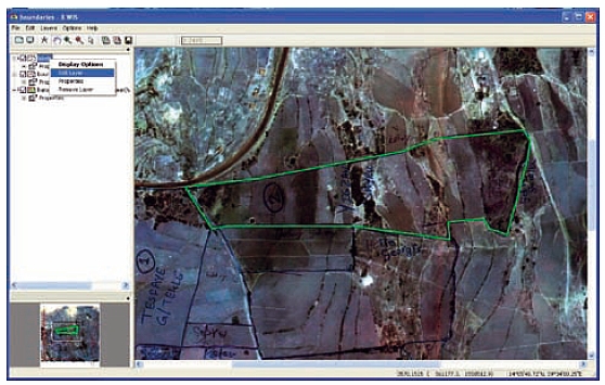
Figure 7: Screendump STDM prototype software. An example case where drawn
boundaries are vectorised to closed polygons. Those polygons can be related to
persons via social tenure relationships.
Capacity building is needed before going to the field. This is easy with
images. The use of ‘digital pens’ seems very interesting for data collection
purposes. With digital pens, the drawn lines on the paper images can be read by
a computer and are geo-referenced immediately. This means that scanning is not
needed.
The use of STDM is most relevant with regard to the maintenance of the data.
How to go from an informal social tenure relationship to a formal one and from a
personal right of use to a formal one? The inventory of informal rights could be
seen as a “what to do list” after integrating the land data collected by the
local community with data from a Land Administration Authority – maybe in
co-operation with other institutions. Sometimes there are objections in
recognising informal rights; the “informal rights” are
called “illegal rights”. This is in fact neglecting what can be observed in
reality. The officials know this. People need a shelter somewhere and in many
cases the government did observe informal areas but did not interfere for a long
time.
How to move from a conflict situation (conflicting claims) to a formal one?
Again a “what to do list” for the government – upgrade the rights or take other
decisions based on the recordation of rights.
Women’s access to land – this can be organised by registration of shares in
rights. This is supported in STDM.
Data quality of spatial data may be improved in a later stage of development.
Note that there may be a serious need for accurate geo data in slum areas: the
value of land in slum areas near city centres can be very high.
In conclusion, the STDM concept is supportive in community based data
acquisitions. This gives people the feeling that the data are their own data.
Later the data can be formalised and integrated in formal systems. This is
possible because of a standardised approach.
Figure 8: Land rights of people living in slum areas are mostly not
recognised or often the situation is considered to be illegal. In any case
inclusion in formal land administrations is not possible. Extensions to formal
land administrations are urgently needed allowing recordation of all people to
land relationships. © Christiaan Lemmen
6. The Process: Developing the STDM
The status and the way forward to completion.
The Global Land Tool Network (GLTN), a coalition of international partners,
including FIG and ITC, has taken up this challenge and is supporting the
development of propoor land management tools, to address the technical gaps
associated with unregistered land, the upgrading of slums and rural land
management, among other things.The security of tenure of people in these areas
relies on forms of tenure different from individual freehold. Most off register
rights and claims are based on social tenures. GLTN partners support a continuum
of land rights, which includes rights that are documented, undocumented, from
individuals and groups, from pastoralist, in slums, which are legal, illegal and
informal.
The technical gap covered by STDM is on the critical path of the delivery of
a number of Millennium Development Goals namely, Goal 1 on food security, Goal 3
on the promotion of gender equality and the empowerment of women, and Goal 7 on
ensuring environmental sustainability, including improving the lives of slum
dwellers.
A first prototype of STDM1 has been developed at ITC for the purpose to test
the concept, the look and feel, and the way transactions are implemented. As
soon as this is evaluated a version will be available to support the input and
maintenance of comprehensive data sets.
The specifications have to be available for software development by open
source communities or by commercial software suppliers. Open Source means that
developments in software can be shared. Both Open Source software and commercial
software will be needed – depending on the level of development of land
administration. Relative small amounts of data may be manageable with open
source software. Huge amounts of data, to be accessible 7 × 24 hours, will
require information management by commercial software, at least as long as there
is insufficient expertise on Open Source products (database and GIS).
In conclusion, STDM is a pro-poor tool and the development of the concept and
a first prototype is funded by GLTN and supported by FIG – the global community
of land administration professionals. The role of FIG is therefore in the area
of advocating this model from a professional point of view and to provide the
professional environment for its development and implementation.
Augustinus, Clarissa (2010): Social tenure domain model: what it can mean
for the land industry and for the poor. XXIV FIG International Congress:
facing the challenges, building the capacity, April 2010, Sydney, Australia.
Augustinus, Clarissa, Christiaan Lemmen and Peter van Oosterom (2006):
Social tenure domain model: requirements from the perspective of pro-poor land
management. 5th FIG regional conference: promoting land administration and
good governance, March 2006, Accra, Ghana.
De Soto, Hernando (2003): The mystery of capital: why capitalism triumphs
in the west and fails everywhere else. New York, NY, US. Basic Books.
Lemmen, Christiaan, Clarissa Augustinus, Peter van Oosterom, and Paul van der
Molen (2007): The social tenure domain model: design of a first draft model.
FIG Working Week 2007: strategic integration of surveying services, May
2007, Hong Kong SAR, China.
UN (2000): United Nations Millennium Goals Declaration. United Nations
General Assembly, New York, US.
Williamson, Enemark, Wallace, and Rajabifard (2010): Land Administration
for Sustainable Development. ESRI Press Academic. Redlands, California, US.
Zevenbergen, Jaap and Solomon Haile (2010): Institutional aspects of
implementing inclusive land information systems like STDM. XXIV FIG
International Congress: facing the challenges, building the capacity, April
2010, Sydney, Australia.
Copyright © International Federation of Surveyors, Global
Land Tool Network and United Nations Human Settlements Programme (UN-HABITAT),
March 2010
All rights reserved
International Federation of Surveyors (FIG)
Kalvebod Brygge 31–33
DK-1780 Copenhagen V
DENMARK
Tel. + 45 38 86 10 81
E-mail: FIG@FIG.net
www.fig.net
Published in English
Copenhagen, Denmark
ISBN 978-87-90907-83-9
Published by
International Federation of Surveyors (FIG)
Front cover: Ethiopia (left), Ghana (middle) © Christiaan
Lemmen;
Bolivia (right) © Ximena Pereira
DISCLAIMER
The designations employed and the presentation of material in this publication
do not imply the expression of any opinion whatsoever on the part of the
secretariat of the United Nations concerning the legal status of any county,
territory, city or area or its authorities, or concerning the delimitation of
its frontiers or boundaries regarding its economic system or degree of
development. Excerpts may be reproduced without authorization, on condition that
the source is indicated. Views expressed in this publication do not necessarily
reflect those of the United Nations Human Settlements Programme, the United
Nations and its member states.
ACKNOWLEDGEMENTS
Without the support and contribution of Dr. Clarissa Augustinus, Prof. Dr. Peter
van Oosterom, Dr. Solomon Haile, Prof. Paul van der Molen, Prof. Dr. Jaap
Zevenbergen and Prof. Stig Enemark the concept of the Social Tenure Domain Model
could not have been developed. Also the ISO 19152 Project Team, drafting the
Land Administration Domain Model, were constructive in their support for the
Social Tenure Domain Model. This is a big step forward in the development of
Land Administration Systems. Martin Schouwenburg, Liliana Alvarez, Jan van
Bennekom-Minnema and Monica Lengoiboni prepared the first STDM prototype
software. Remy Sietchiping and Hemayet Hossain provided valuable advice during
the development. Thanks for all your support.
Editors: Harry Uitermark and Christiaan Lemmen
Design: International Federation of Surveyors, FIG
Printer: Oriveden Kirjapaino, Finland
|