Article of the Month -
April 2007
|
Integrated Land-Use Management for Sustainable
Development
Prof. Stig ENEMARK, FIG President, Denmark

 This article in .pdf-format.
SUMMARY
The paper addresses the issue of informal urban development with a
special focus on planning control and integrated land-use management as a
means to prevent and legalise such development.
In this context the paper presents an overall understanding of the land
management paradigm for sustainable development. The paper then identifies
the diversity of planning systems in a European context and the key legal
means of control.
Planning is politics. The framework for political decision-making should
therefore be organised to facilitate an integrated approach to land-use
management that combines the three areas of land policies, land information
management, and land-use management. Such a framework, that includes
monitoring and enforcement procedures, should support sustainable
development, and, at the same time, provide the basic means for preventing
and legalising informal urban development.
1. INTRODUCTION
The paper addresses the issue of informal urban development with a
special focus on planning control and integrated land-use management as a
means to prevent and legalise such development. The Paper is focusing mainly
on the European region.
Today there are about 1 billion slum dwellers in the world, while in 1990
there was about 715 million. UN-Habitat estimates that if the current trends
continue, the slum population will reach 1.4 billion by 2020 if no remedial
action is taken. In 2005 the world´s urban population was about 3.2 billion
out of world total of about 6.5 billion. Current trends predict the number
of urban dwellers will keep rising, reaching almost 5 billion in 2030 where
80% will live in developing countries. Over the next 25 years, the world´s
urban population is expected to grow at an annual rate of almost twice the
growth rate of the world´s total population. (UN-Habitat, 2006).
In this perspective, where one of every three city residents live in
inadequate housing with few or no basic services, it becomes urgent to focus
on informal settlement and find ways and means to influence government
policies and actions. This also relates to the Millennium Development Goal
7, target 11 stating that by 2020 to have improved the lives of least 100
million slum dwellers.
The Millennium Development Goals provide an apt framework for linking the
wealth of cities with increased opportunity and improved quality of life for
their poorest residents. In many countries, however, prosperity has not
benefited urban residents equally. Mounting evidence suggests that economic
growth in itself cannot reduce poverty or opportunities if it is not
accompanied by equitable policies that allow low-income or disadvantaged
groups to benefit from that growth (UN-Habitat, 2006).
In the European region informal urban development do occur to some
extent, especially in Mediterranean countries, even if the scale is much
smaller and also different to the situation in most developing countries.
But, in principle, the problems are the same and relate to factors such as
lack of adequate legal structures; lack of social and economic institutions
for providing and financing low cost housing; lack of updated records and
maps and monitoring procedures; bureaucracy and lack of transparency;
expensive and time consuming procedures for obtaining the relevant permits
and registrations; and political reluctance (Potsiou, 2006).
At the more global scale FIG is committed to the UN-Habitat agenda around
the Global Land Tool Network (GLTN) that aims to facilitate the attainment
of the Millennium Development Goals through improved land management and
tenure tools for poverty alleviation and the improvement of the livelihoods
for the poor.
2. INFORMAL URBAN DEVELOPMENT
Informal urban development may occur in various forms such as squatting
where vacant state-owned or private land is occupied illegally and used for
illegal slum housing; informal subdivisions and illegal construction work
that do not comply with planning regulations such as zoning provisions; and
illegal construction works or extensions on existing legal properties
(Potsiou, 2006).
There is no simple solution to the problem of preventing and legalising
informal urban development. The problem relates mainly to the national level
of economic wealth in combination with the level of social and economic
equity in society, while the solutions relate to the level of consistent
land policies, good governance, and well established institutions.
Land policies may be seen as the set of aims and objectives set by
governments for dealing with land issues. Policy implementation depends on
how access to land and land related opportunities are allocated. Governments
therefore regulate land related activities, including holding rights to
land, controlling the economic aspects of land, and controlling the use of
land and its development. Administration systems surrounding these
regulatory patterns facilitate the implementation of land policy in the
broadest sense, and in well organized systems, they deliver sensible land
management and good governance.
In this regard it is important to understand the dimensions and
implication of land management as a paradigm for dealing with land rights,
restrictions and responsibilities. This is explained in more details in
section 3 below.
It is important to note, however, that where the problem of unauthorised
developments occurs, the particular characteristics of the planning system
may only play a minor part in explaining it. Factors outside the formal
planning system will often play a determining role in its operation and
effectiveness. Factors such as the historical relationship between citizens
and government, attitudes towards land and property ownership, and
implications of social and economics institutions in society will all play a
part amongst other historical and cultural conditions (European Commission,
1997).
3. UNDERSTANDING THE LAND MANAGEMENT PARADIGM
Land management encompasses all activities associated with the management
of land and natural resources that are required to achieve sustainable
development. The concept of land includes properties and natural resources
and thereby encompasses the total natural and build environment.
The organisational structures for land management differ widely between
countries and regions throughout the world, and reflect local cultural and
judicial settings. The institutional arrangements may change over time to
better support the implementation of land policies and good governance.
Within this country context, the land management activities may be described
by the three components: Land Policies, Land Information Infrastructures,
and Land Administration Functions in support of Sustainable Development.
This Land Management Paradigm is presented in Figure 1 below (Enemark et
al., 2005):
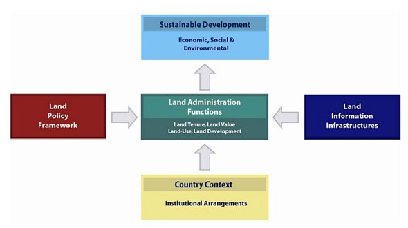
Figure 1. The land management paradigm
Land policy is part of the national policy on promoting objectives
including economic development, social justice and equity, and political
stability. Land policies may be associated with: security of tenure; land
markets (particularly land transactions and access to credit); real property
taxation; sustainable management and control of land use, natural resources
and the environment; the provision of land for the poor, ethnic minorities
and women; and measures to prevent land speculation and to manage land
disputes.
The operational component of the land management paradigm is the range of
land administration functions that ensure proper management of rights,
restrictions, responsibilities and risks in relation to property, land and
natural resources. These functions include the areas of land tenure
(securing and transferring rights in land and natural resources); land value
(valuation and taxation of land and properties); land use (planning and
control of the use of land and natural resources); and land development
(implementing utilities, infrastructure and construction planning).
The land administration functions are based on and are facilitated by
appropriate land information infrastructures. The land information area
should be organised to combine cadastral and topographic data, and link the
built environment (including legal and social land rights) with the natural
environment (including topographical, environmental and natural resource
issues). Land information should, this way, be organised as a spatial data
infrastructure at national, regional/federal and local levels based on
relevant policies for data sharing, cost recovery, access to data, data
models, and standards.
The four land administration functions (land tenure, land value, land
use, land development) are different in their professional focus, and are
normally undertaken by a mix of professions, including surveyors, engineers,
lawyers, valuers, land economists, planners, and developers. The
interrelations appear through the fact that the actual conceptual, economic
and physical uses of land and properties influence land values. Land value
is also influenced by the possible future use of land as determined through
zoning, land use planning regulations, and permit granting processes. And
the land use planning and policies will, of course, determine and regulate
future land development.
Sound land management is the operational processes of implementing land
policies in comprehensive and sustainable ways. In many countries, however,
there is a tendency to separate land tenure rights from land use rights.
There is then no effective institutional mechanism for linking planning and
land use controls with land values and the operation of the land market.
These problems are often compounded by poor administrative and management
procedures that fail to deliver required services. Investment in new
technology will only go a small way towards solving a much deeper problem;
the failure to treat land and its resources as a coherent whole.
With regard to Europe, and talking about informal urban development,
there is also still some way to go. Many countries in Europe, especially in
the southern and eastern regions, are facing problems in this regard. To
deal with this it is important to understand the cultural diversity within
the European region and also the deriving diversity of planning systems
within the European territory. This is presented in more details in the
following chapter.
4. DIVERSITY OF PLANNING SYSTEMS IN EUROPE
There is no such thing as the common planning system for the European
countries. Planning systems varies considerably in terms of scope, maturity
and completeness, and the distance between expressed objectives and
outcomes. The systems also varies in terms of the locus of power e.g.
centralisation versus decentralisation, and the relative role of the public
and private sector e.g. planning led versus market led approach (European
Commission, 1997).
More generally, planning systems are to some extent determined by the
cultural and administrative development of the country or jurisdiction –
just like is the case for cadastral systems. With regard to understanding
the diversity of planning systems there is some merit in having a look at
the cultural map of the world as offered by the Dutch sociologist Geert
Hofstede (2001) as shown in figure 2 below.
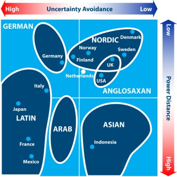
Figure 2. The cultural map of the world. Adapted form Gert Hofstede,
(2001).
Geert Hofstede divides the world’s cultures into four
squares using the two axes of:
The point is that the issues of uncertainty avoidance and
power distance are both fundamental for the design of planning systems in
any country or jurisdiction. Planning systems therefore varies according
their cultural base. This explains why for example the systems in Nordic and
Latin countries are quite different.
4.1 Traditions of spatial planning
Four major traditions of spatial planning can be identified within the
European countries (European Commission, 1997):
- The regional economic planning approach, where spatial planning is
used as a policy tool to pursue wide social and economic objectives,
especially in relation to disparities in wealth, employment and social
conditions between different regions of the country. Central government
inevitably plays a strong role. France is normally seen as associated
with this approach.
- The comprehensive integrated approach, where spatial planning is
conducted through a systematic and formal hierarchy of plans. These are
organised in a system of framework control, where plans at lower levels
must not contradict planning decisions at higher levels. Denmark and the
Netherlands are associated with this approach. In the Nordic countries
local authorities play a dominant role, while in federal systems such a
Germany the regional government also play a very important role.
- The land use management approach, where planning is a more technical
discipline in relation to the control of chance of use of land. The UK
tradition of “town and country planning” is the main example of this
tradition, where regulation is aiming to ensure the development and
growth is sustainable.
- The Urbanism approach, where the key focus is on the architectural
flavour and urban design. This tradition is significant in the
Mediterranean countries and is exercised through rather rigid zoning and
codes and through a wide range of laws and regulations.
4.2 Operations of planning systems
Another classification can be made in relation to how the systems
operate. Two characteristics can be identified in this regard: the extent of
discretion or flexibility in decision making to allow for development that
is not in line with the adopted planning regulations; and the degree of
unauthorised development e.g. as to whether there is a close, moderate or
distant relation between the stated objectives and the actual development.
By drawing these two categories together, the European countries can be
classified as follows (European Commission 1997):
- The UK has a discretionary system and yet there tends to be a close
relationship between objectives of the system and the actual
development.
- Denmark, Finland, Ireland, and the Netherlands have a moderate
degree of flexibility in decision making, and planning objectives and
policies are close to development that takes place.
- France, Germany, Luxemburg and Sweden all have systems which have
little flexibility in operation, and where development in generally in
conformity with the planning regulations.
- Belgium and Spain both have rather committed systems while there is
only moderate relationship between objectives and reality.
- Finally there is group of countries, Greece, Italy and Portugal,
where the systems are based upon the principle of committed decisions in
plans, but where in practice there has been considerable discrepancy
between the planning objectives and reality.
It must be mentioned, that classifications such as presented above can
only be seen as a very general overview, while, in the details, there may be
all kind of nuances that reflect the specific conditions and cultural
tradition of the individual country.
5. LEGAL MEANS OF PLANNING CONTROL
The relative roles of the public and the private sector refers to the
extent to which the realisation of spatial planning policy is reliant on
public or private sources and the extent to which development might be
characterised as predominantly plan-led or market-led.
The Danish system, for instance, is mainly plan-led and highly
decentralised. The Ministry of the Environment establishes the overall
framework in terms of policies, guidelines and directives. Development
possibilities are determined through the general planning regulations at
local level (municipalities), and further detailed in the legally binding
local/neighbourhood plans. Municipalities are also responsible for granting
of building permits that serve as a final control in the system. Planning at
municipal level is comprehensive and includes determination of land
policies, land use planning, and land use regulations in term of urban/rural
zoning and regulation frameworks for the content of more detailed and
legally binding local/neighbourhood plans that must be provided prior to any
major developments.
The comprehensive municipal plans as well as the local/neighbourhood
plans have to be submitted for public debate and for public inspections and
objections before final adoption. This provides for public participation in
the planning process at all levels. On the other hand, there is no
opportunity for an appeal, inquiry or compensation regarding the contents of
an adopted plan, even the binding local plans. Planning is considered as
politics and the procedures of public participation mentioned above are
regarded as adequate for the legitimacy of the political decision.
However, planning regulations established by the planning system are
mainly restrictive. The system may ensure that undesirable development does
not occur, but the system will not be able to ensure that desirable
development actually happens at the right place and at the right time, as
the planning intentions are mainly realised through private developments.
When there is a development proposal which is not in line with the plan,
either a minor departure from the plan may be allowed, or the plan itself
has to be changed prior to implementation. This process includes public
participation, and the development opportunities are finally determined by
the municipal council. On the other hand, development proposals that conform
to the adopted planning regulations are easily implemented without any time
delay. These legal means of planning control are shown in figure 3 below.
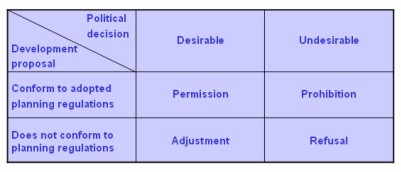
Figure 3. The legal means of planning control (Enemark 1999)
5. PLANNING IS POLITICS
Any planning policy or strategy will have to consider a
number of contradicting professional and political attitudes to development
control such as a social versus a liberal approach, and growth versus a
balanced approach. In planning terms this refers to approaches such as
regulation versus deregulation, and centralization versus decentralization.
This shows that planning is politics. However, to be robust comprehensive
planning must be based on all four approaches and methods of planning in
order to appear as legitimate. This will include a balance between the
functional land-use regulations normally designed by the professional
planner; the demand for control and economic growth that is the traditional
role of the politicians; the wishes for free market investments coming from
the developer; and the often more grass-root based demands articulated by
the citizens. The general trends in Europe in terms of the role of the
planning systems are shown in figure 4 below.
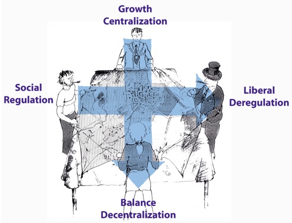
Figure 4. The general trends in Europe in terms of the
political attitudes and planning approaches.
6. INTEGRATED LAND-USE MANAGEMENT
An integrated system of Land-Use Management for Sustainable Development
is shown in figure 5 below.
Integrated land-use management is based on land policies laid down in the
overall land policy laws such as the Cadastral/Land Registration Act; and
The Planning/Building Act. These laws identify the institutional principles
end procedures for the areas of land and property registration, land-use
panning, and land development. More specific land policies are laid down in
the sectoral land laws within areas such as Agriculture, Forestry, Housing,
Natural Resources, Environmental Protection, Water supply, Heritage, etc.
These laws identify the objectives within the various areas and the
institutional arrangements to achieve these objectives through permit
procedures etc. The various areas produce sectoral programmes that include
the collection of relevant information for decision making within each area.
These programmes feed into the comprehensive spatial planning carried out at
national, state/regional and local level.
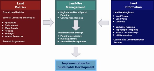
Figure 5. Integrated land-use management for sustainable
development (Enemark, 2004).
Furthermore, the system of comprehensive planning control is based on
appropriate and updated Land Use Data Systems, such as the Cadastral
Register, the Land Book, the Property Valuation Register, the Building and
Dwelling Register, etc. These registers are organized to form a network of
integrated subsystems connected to the cadastral and topographic maps to
form a national spatial data infrastructure for the natural and built
environment.
In the Land-Use Management System (the Planning Control System) the
various sectoral interests are balanced against the overall development
objectives for a given location and thereby form the basis for regulation of
future land-use through planning permissions, building permits and sectoral
land use permits according to the various land-use laws. These decisions are
based on the relevant land use data and thereby reflect the spatial
consequences for the land as well as the people. In principle it can then be
ensured that implementation will happen in support of sustainable
development.
A global approach to land management, as presented above, depends on
appropriate structures of governance. In this regard, the issue of
decentralisation may be seen as a significant key to achieving the general
aim of sustainable development. In the Nordic setting, and many other places
around the world, the obvious local arena for land-use planning and
decision-making has been the commune - the municipality. It is argued that
whatever outcome may emerge from a decentralised system of decision-making
it must be assumed to be the right decisions in relation to local needs.
Decentralisation thus institutionalises the participation of those affected
by the local decisions. This argument is particularly valid in the area of
land-use decision-making and administration. Land-use planning this way
becomes an integrated part of local politics within the framework of plans
and policies provided at regional and national level. The purpose is to
solve the tasks at the lowest possible level so as to combine responsibility
for decision making with accountability for financial, social, and
environmental consequences.
Another principle in relation to this concept of integrated land-use
management is about comprehensive planning that combines policies and
land-use regulations into one planning document covering the total
jurisdiction. Presentation of political aims and objectives as well as
problems and preconditions, should then justify the land-use planning and
the more detailed land-use regulations. This also relates to public
participation that should serve as a means to create a broader awareness and
understanding of the need for planning regulations and enable a dialogue
between government and citizens around the management of natural resources
and the total urban and rural environment. Eventually, this dialogue should
legitimise the local political decision making. In terms of informal urban
or rural development there is a need for a monitoring system e.g. through
continuing updating of the large scale topographic map base, and proper
enforcement procedures to decide on such development in relation to the
overall land policies.
7. FINAL REMARKS
This paper does not attempt to present an overall global approach to
planning systems and policies in Europe or a comparative analysis of the
maturity or completeness of systems. In fact, the systems can hardly be
compared since the cultural and institutional conditions various throughout
the regions of the European territory – even the terminology and the meaning
of spatial planning vary a lot. Instead, the paper attempts to identify some
general characteristics while the key issue of planning control is discussed
in more details.
The concept of integrated land management is presented as a means to
support sustainable development, and, at the same time, prevent and legalise
informal urban development. The integration of land policies, land
information, and planning control/land-use management should ensure that
land-use decision making is based on relevant policies and supported by
complete and up to date information on land-use and rights in land. This
should also provide for establishing the relevant social and economic
institutions in society in support of legalising the informal sector.
The land management paradigm drives systems dealing with land rights,
restrictions and responsibilities to support sustainable development, and it
facilitates a holistic approach to management of land as the key asset of
any jurisdiction. This represents a huge political challenge. It also
represents a major challenge to the global surveying community that is seen
as the key player in building and running these systems. Understanding the
land management paradigm is the key to building integrated and mature
systems that link policy making, good governance, land administration
systems, and land information infrastructures to form a coherent approach
for dealing with land issues to improve living conditions for all.
Arguably, establishment of such mature systems that are trusted by the
citizens is also the key to preventing and legalising informal urban
development. This goes for, at least, the developed part of the world. In
developing countries this approach must be supplemented by a range of
measures that address the issues of poverty, health, education, economic
growth, and tenure security. This is all included in the perspectives of the
Millennium Development Goals. FIG and the global surveying community will
respond very committed to the MDG´s over the coming years.
REFERENCES
- Alterman, R., (Ed.) (1998): National level Planning in Democratic
Countries – An international comparison of city and regional
policy-making. Liverpool University Press.
- Enemark, S. (1999): Denmark – the EU Compendium of spatial planning
systems and policies. Brussels. ISBN 92-828-2693-7. 124 pp.
- Enemark, S. (2004): Building Land Information Policies. Proceedings
of Special Forum on Building Land Information Policies in the Americas.
Aguascalientes, Mexico, 26-27 October 2004.
http://www.fig.net/pub/mexico/papers_eng/ts2_enemark_eng.pdf
- Enemark, S., Williamson, I., and Wallace, J. (2005): Building Modern
Land Administration Systems in Developed Economies. Journal of Spatial
Science, Perth, Australia, Vol. 50, No. 2, pp 51-68.
- European Commission (1997): The EU compendium of spatial planning
systems and policies. Brussels. ISBN 92-827-9752-X. 192 pp.
- Hofstede, G. (2001): Culture's Consequences: Comparing Values,
Behaviours, Institutions and Organizations Across Nations, 2nd Edition,
Thousand Oaks CA: Sage Publications.
- Potsiou, C. and Ionnidis, C. (2006): Informal Settlements in Greece:
The Mystery of Missing Information and the Difficulty of their
Integration into the Legal framework. Proceedings of the 5th FIG
Regional Conference, Accra, Ghana, March 8-11, 2006, 20 p.
http://www.fig.net/pub/accra/papers/ts03/ts03_04_potsiou_ioannidis.pdf
- UN-Habitat (2006): State of the World´s Cities 2006/7. UN-Habitat,
Nairobi. ISBN: 92/1/131811-4,
http://www.unhabitat.org/pmss/getPage.asp?page=bookView&book=2101
BIOGRAPHICAL NOTES
Stig Enemark is President of the International Federation of
Surveyors, FIG. He is Professor in Land Management and Problem Based
Learning at Aalborg University, Denmark, where he was Head of the School of
Surveying and Planning 1991-2005. He is Master of Science in Surveying,
Planning and Land Management and he obtained his license for cadastral
surveying in 1970. He worked for ten years as a consultant surveyor in
private practice. He was President of the Danish Association of Chartered
Surveyors 2003-2006. He was Chairman of Commission 2 (Professional
Education) of the International Federation of Surveyors (FIG) 1994-98, and
he is an Honorary Member of FIG. He has undertaken consultancies for the
World Bank and the European Union especially in Eastern Europe and Sub
Saharan Africa. He has more than 250 publications to his credit, and he has
presented invited papers to more than 60 international conferences. For
further information and a full list of publications see
http://www.land.aau.dk/~enemark
CONTACTS
Professor Stig Enemark
FIG President
Aalborg University, Department of Development and Planning
Fibigerstrede 11, DK 9220 Aalborg
DENMARK
Tel. +45 9940 8344; Fax + 45 9815 6541
Email: enemark@land.aau.dk
Web site: www.land.aau.dk/~enemark
 |


