Article of the Month -
June 2009
|
Push the Button – or Does the
“Art of Measurement” Still Exist
Prof. Dr.-Ing. Rudolf STAIGER
University of Applied Sciences Bochum, Germany
Chair of FIG Commission 5

 This article in .pdf-format (17
pages and 1251 KB)
This article in .pdf-format (17
pages and 1251 KB)
1) This paper has been prepared and
presented as a keynote presentation in Plenary Session 3 – GNSS,
Geo-sciences and Surveying at the FIG Working Week 2009 in Eilat,
Israel, 7 May 2009.
Key words: art of measurement, technological change, skills
for surveying, measurement process, surveying measurements.
SUMMARY
The entire geodetic measurement technique has changed significantly
during the last 30 years. In former days the observations were tedious
and cumbersome; the quality of the measurements depended directly on the
capabilities of the observer. Today our surveying instruments are
automatic measuring devices; their results no longer depend on the sharp
eyes of users. “Measurements are so easy – just push the button.” This
is one important advertising slogan used by all the manufacturers. And
it describes the reality: we do not know what is going on inside our
instruments, but today the data acquisition itself is easier and much
more efficient than it was in past decades. The flow of our data is
automatic, as is the entire process of data treatment and calculation.
So is there any “art of measurement” left or still needed?
In order to answer this question the different eras of surveying will
be described and analyzed carefully. Data acquisition has become much
easier, but this does not mean that our measurement results are
error-free. Nor does it mean that we control the entire measurement
process! Are there still mistakes in our data? How do we have to control
our measurements in order to prevent undetected outliers or significant
systematic deviations? Can we estimate our overall precision and
accuracy?
The art of measurement still exists, but it is different from the
traditional one. It consists, very generally speaking, in the successful
design and control of the entire measurement process. What this means
will be explained in detail. And it will certainly be much more than
just “pushing the button”.
ZUSAMMENFASSUNG
Die geodätische Messtechnik hat sich in den letzten 30 Jahren stark
gewandelt. Aufgrund der vielen Innovationen durch die Hersteller, ist
die Datenerfassung und -auswertung viel einfacher und effizienter
geworden. Gleichzeitig ist der direkte Einfluss des Anwenders auf die
Ergebnisse stark zurückgegangen. Die Kunst des Messens besteht heute
nicht mehr im „sorgfältigen Koinzidieren und Anzielen“, sondern in der
Beherrschung des gesamten Mess- und Auswerteprozesses von der Planung
bis zum Endergebnis. Dabei ist ein besonderer Augenmerk auf eine
umfassende und möglichst unabhängige Kontrolle des gesamten
Messprojektes zu richten.
1. INTRODUCTION
“Measurements are so easy – just push the button.” This is one
important message from numerous advertising slogans for surveying
equipment. In reality, the acquisition of surveying data is much easier
and faster today than it was 30 years ago. This is thanks to ongoing
development of the main instruments (total stations, digital levels, and
GNSS-receivers) by all manufacturers. As measurements are so easy to
achieve there are several questions to raise:
- What is the value of the science of measurement, when the data
acquisition is so easy?
- Which knowledge and capabilities must a surveying engineer
possess nowadays to use geodetic instruments successfully?
- Does the “art of measurement” still exist? Or is everybody today
capable of acquiring and treating geodetic data without specific
skills or profound knowledge of surveying?
In order to answer these questions, we will begin with a short review
of the different eras of surveying instruments. Thereafter the actual
situation will be analyzed from different points of view, and finally
the “art of measurement” will be discussed.
1.1 In fact – What is Measuring?
Leonard Euler (1701–1783) described the process of measurement:
“There is only one way to determine and size a value. We have to compare
it with a known size of the same type.” This more than 250 year old
definition is still valid today. The famous Swiss mathematician
continued by saying: “Physics is nothing else than a science, looking
for methods for the measurement of values”. Metrology is the science of
accurate measurements and as such probably as old as mankind. The German
scientist Hermann von Helmholtz founded modern metrology by defining a
consistent methodology for all type of measurements in the natural
sciences (HELMHOLTZ, 1887).
The reasons for executing measurements are manifold. The main causes
are the search for:
- Increased knowledge and cognition. The science of
measurement is indispensable and plays a fundamental role in all
natural sciences.
- More objectivity and consumer protection. All goods and
services on the public market are quantified today in standardized
units and in most of our countries are under strict public control.
- Automation, quality control, and quality improvement of
technical processes. A key element in the fully automated
production of parts or entire products is so-called production
measurement technology, which is an essential precondition for an
automated industrial production.
- Security. Passenger transportation systems of all kind
(airplanes, trains, ships, cars, aerial railways, elevators, etc.)
are using sophisticated measurement systems in order to assure safe
and comfortable transport.
1.2 The Historical Development of Surveying Instruments
Measuring and surveying are not only activities which have been
performed for thousands of years; they are furthermore an important part
of our history of civilization. The technical development of surveying
instruments can be divided roughly into four different phases (Fig. 1).
The archaic Phase lasted thousands of years and ended in 1590 with the
invention of the telescope.
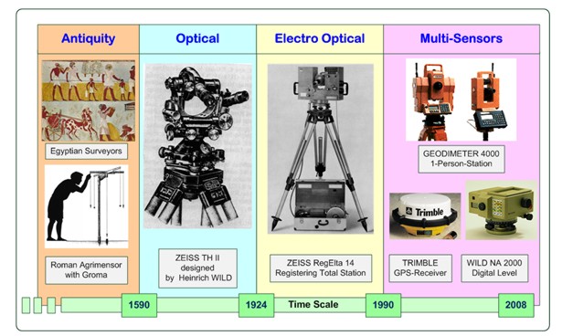
Fig. 1: The four different phases of surveying instruments
The following Optical Era persisted for more than 300 years and had
its peak at the end in around 1920 with the presentation of the first
modern theodolite, Zeiss TH II, designed by the ingenious Swiss inventor
Heinrich Wild. The technical progress during the Electro-Optical Phase
was tremendous. At the end of the 1980s most electronic total stations
offered coaxial (angle and distance) measurements, were equipped with a
compensator, and allowed digital storage of the measured points.
1990 started the Phase of Multi-Sensor-Systems, which continues
today. In this year the first digital level (WILD NA 2000) and the first
motorized total station (GEODIMETER 4000) were presented. At the same
time the GPS was announced as the new universal positioning technique,
which makes traditional instruments like total stations needless. In the
following years, all types of geodetic instruments were improved in
respect of greater efficiency and new functionalities. Figure 2 shows
the progress of total stations and GNSS-receivers. It is interesting to
note that instead of talking about the substitution of tacheometry by
satellite based systems everybody is actually propagating the combined
use of both technologies.
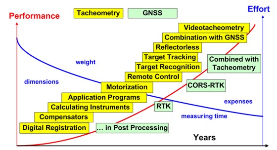
Fig. 2: The different steps of progress for tacheometry and GNSS
during the last 20 years.
2. SURVEYING INSTRUMENTS TODAY
The main instruments of the surveyor nowadays are the digital level,
the total station, and the GNSS-receiver.
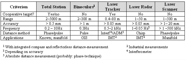
Table 1: Different realizations of the combined use of angles and
distances
The combined measurement of angles and distances deliver polar
coordinates in the two- or three-dimensional space. Based on this
principle we find different types of instruments (Table 1).
Terrestrial laser scanning (TLS) is in theory also part of the
polar-coordinate-family, but the use and the applications themselves are
quite different from those of the other instruments. The traditional
acquisition methods of the surveyor are “point-orientated”, while TLS
has to be considered as an “element-orientated” approach. The invention
of electronic total stations and GNSS-receivers led to the substitution
of existing measurement systems. Methods of measuring points were
replaced by other methods which are more accurate and more efficient
(Table 2).
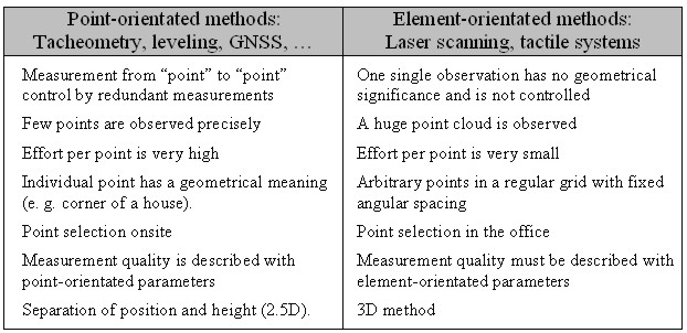
Table 2: Principal differences between point-orientated and
element-orientated measurements
For laser scanners the situation is different. With their
capabilities – digitizing entire objects in detail – they enlarge the
“tool-box” of the surveyor. New applications and innovative products can
be realized which would not have been feasible with traditional
surveying equipment due to economical or technical limitations.
2.1 Characterization of the Actual Surveying Equipment
We have noticed an enormous increase in functionality during the last
20 years thanks to manufacturers. All actual measurement systems are
multi-sensor-systems, which are equipped with several sensors and driven
by one or more microprocessors (Fig. 3). Raw observation values as we
know them, for example from angular observations with an optical
theodolite, no longer exist. The actual values shown on the display of
the instrument are the result of multiple sensor readings, modified by a
range of geometrical and physical parameters. These correction
parameters and the entire correction model are not accessible to the
user. The multiple sensor readings are used for the validation of the
measurement itself (detection of outliers, beam interruption, etc.) and
at the same time for an increase in accuracy.
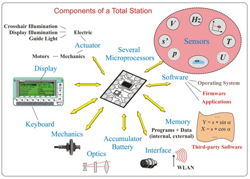
Fig. 3: Components of a modern total station
A modern total station is nothing more than a mobile PC with
geometrical sensors. The observer (with a direct influence on the
measurement) is downgraded to the user of a system. The internal
processes remain hidden and the manufacturers do not publish information
about the technologies used in their instruments. Today many instruments
can also be used as autonomous remote controlled measurement devices.
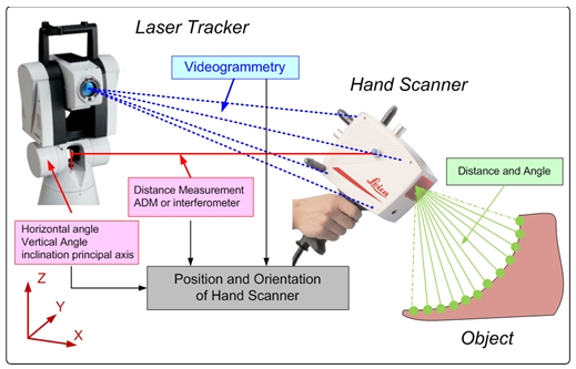
Fig. 4: Laser tracker with hand scanner as an example of a
multi-sensor-system
A laser tracker combined with a hand scanner is a good example of the
complexity of the actual measurement systems (Fig. 4). The determination
of the position and orientation of the hand scanner relative to the
tracker is realized in real-time with measured angles and distances
(position) combined with videogrammetry (orientation). The coordinates
of the object are determined in relation to the actual position and
orientation of the hand scanner.
During the last 70 years the accuracy of our measurement systems has
not always been improved. Height determination became faster and simpler
with the introduction of digital levels, but there has been no systemic
enhancement of accuracy. The situation for the measurement of directions
and angles is quite similar. In contrast to this are electronically
measured distances: we note that there has been a significant
advancement in precision and accuracy.
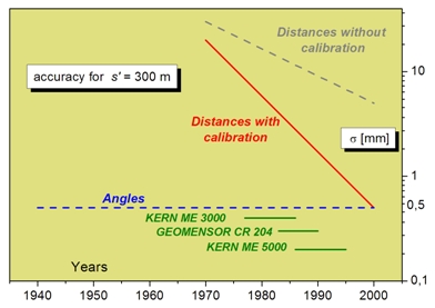
Fig. 5: Development of accuracy of angles and distances for a
distance of 300 m.
2.2 Measuring – the Customer’s View
The measurement techniques and applications have changed
significantly. The main characteristics are:
- The customer is using instruments like a black box. This
means he or she has, in general, no idea about the internal
technical processes of the instrument. The functionality of the
system and the software is so extensive that he or she is using only
a small fraction of it.
- Eighty per cent of the measurements are not controlled.
- The user is convinced that the results are “true”, and
does not care for a regular check of the entire equipment.
- The life cycle of a specific instrument (normally three
to five years) is in general too short for the user.
2.3 Measuring – the Manufacturer’s View
During recent decades we have observed a strong concentration in the
market. Today LEICA, TOPCON, and TRIMBLE share the world market between
them. Economically, “surveying” is not easy as a business. On the one
hand there are only a few vendors, but on the other hand the clients are
demanding and not always investment-friendly and the whole branch is not
considered a growth sector. The main aspects for the vendors are:
- Actual measuring systems are powerful, reliable, and
easy-to-use.
- The manufacturers are confronted with product piracy from
China.
- There are different reasons why a new product or model
appears on the market, but only the first of the listed reasons is
obvious to the user.
- Innovation. A new functionality is introduced onto
the market, for example, automatic target recognition or
automatic target tracking.
- Non-availability of electronic components. If the
OEM-components are no longer available the manufacturer is
forced to redesign its instrument, despite the fact that there
is no need from the customer’s point of view.
- Reduction in manufacturing costs. In order to reduce
the production costs, manufacturers revise their products. Often
only a complete redesign leads to the desired results.
- Not every product which could be developed technically appears
as a product on the market. The (potential) economical success (or
return on investment, ROI) in relation to the costs of development
must be promising, otherwise the idea will not become a real
product. Two examples will clarify this statement.
- Fully automated leveling system. All manufacturers
have the technical potential to develop a fully automated
leveling system. The only manual operation would be the rough
setup of the instrument and the rods. The rest (leveling of the
instrument, searching for the rods, focusing, measuring,
calculating, etc.) could be fully automated.
- Precise distance measurements. The most accurate
geodetic distance measurement device is the KERN Mekometer ME
5000 (cf. Fig. 5). It can only measure distances and a single
measurement lasts about two minutes. Today it would be possible
to integrate this technology into a total station and to achieve
similar results with it within a fraction of a second.
2.4 Measuring – the Metrologist’s View
Metrology is the science of measurements. One important task of
metrology is to ensure worldwide uniformity of measurements and their
traceability to the International System of Units (SI). From this point
of view it can be stated that:
- All new instruments fulfil the manufacturers’ geometrical
specifications.
- Despite the high grade of automation, our results are still
influenced directly and indirectly by the user. Considering the
standard task “determination of the geometrical relationship between
the ground points A and B” (Fig. 6a), we discover that besides the
measurements themselves there are the manual operations: centering,
leveling, and height determination of the targets and the
instrument. If we execute this task with satellite based systems
(GNSS), the necessary manual operations and measurements remain the
same.
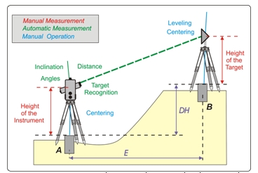
Fig. 6a: Measurements between the ground points A and B.
In addition we have to consider the correctness of the parameters for
instrumental, geometrical, and physical corrections as well as all the
steps of geodetic calculation executed with the instrument (Fig. 6b).
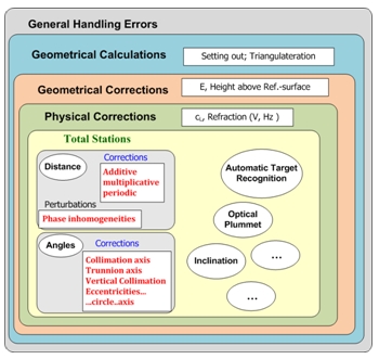
Fig. 6b: Shell-model of possible errors for a total station.
- Geodetic measurements are not always traceable to SI-Units.
- The specifications regarding the accuracy and
reliability of GNSS-measurements are in general very vague and
not satisfying. These measurements are subject to a variety of
external influences, like satellite constellation, accuracy of orbit
parameters, multipath effects, and the influence of the ionosphere.
The quality of the point determination depends not only on these
factors but also on the time and duration of the observation itself.
These circumstances are already observable on studying the footnotes
of the technical specifications of GNSS-receivers: “Accuracy and
reliability may be subject to anomalies due to multipaths,
obstructions, and satellite geometry. Always follow recommended
survey practices.”
2.5 The Limits of Accuracy
A measuring system consists of all the components which contribute to
the final result. It is constructed not only of the instrument including
the accessories but also of the quantity to be measured, the physical
environment, the observer (user), and finally the measurement and
calculation method in use. If we want to indicate an overall accuracy we
have to consider the whole system.
2.5.1 The limits of accuracy in the past
In former days, achievable measurement accuracy was limited mainly by
the observer and his imprecise surveying equipment. Some characteristics
typical of that time were as follows:
- The observer had a direct influence on the quality of the
measurements (pointing, bringing into coincidence, reading, …).
Surveying was a handcraft, demanding a lot of experience and skills.
- The accuracy of one single measurement was in general not
sufficient. Therefore repetitions became mandatory. This also led to
several useful side-effects:
- Outliers could be detected.
- The differences between the measurements also served as
immediate indicators of the actual repeatability.
- The accuracy was improved not only by repetitions but also by
well-considered observation sequences. Everybody knows that the
angle measurement on both faces included the reversed observation
sequence on the second face. The benefit of such a sequence is the
elimination of systematic error influences (in this case the “tripod
distortion”).
2.5.2 The limits of accuracy in the present
With the current generation of surveying equipment precise
measurements are easy to achieve, but the user often underestimates the
risk of possible errors. The components physical environment and
equipment are actually limiting our achievable accuracy:
- Physical environment. Here the influence of the
atmosphere on our measurements is the main focus. Refraction is
limiting the accuracy of observed horizontal and vertical angles as
well as determined distances. During the last 20 years,
manufacturers have improved the accuracy of measured distances by a
factor of 5 to 10. In order to also make use of this accuracy for
longer distances (s > 200 m) we must determine the representative
meteorological parameters (air temperature and air pressure) very
accurately onsite. If a distance of about 500 m is to be determined
with an accuracy of 0.5 mm, the representative air temperature must
be known with an uncertainty smaller than 1 °C!
- Measurement equipment. Manufacturers have improved
instruments during recent decades, but not all accessories have been
adapted to this progress:
- Tripods. Different investigations indicate
significant vibrations (INGENSAND, 2001) and horizontal torsions
(DEPENTHAL, 2004) when motorized total stations are used in
combination with normal tripods. But vendors are not offering or
even promoting high quality tripods which fulfil the special
needs of motorized instruments.
- Optical plummets. Today we can measure in limited
areas (s < 150 m) “below the millimeter”. The transfer of these
highly accurate measurements onto the benchmarks fails due to
optical plummets, which have not improved in accuracy during the
last decades.
Today, fieldwork is not always exercised with reasonable care. The
user is convinced that his instrument is error-free and that no special
treatment such as protection against direct sunlight is necessary. In
contrast to this behavior are investigations which indicate clearly that
digital levels show significantly bigger variations in the line of sight
– due to changes in the temperature of the instrument – than optical
levels (STAIGER, 1998). If a survey umbrella is not in use, additional
effects occur due to one-sided heating caused by sunlight.
3. AGELESS PRINCIPLES IN SURVEYING
If we are searching for ageless principles for geodetic measurements,
it is hard to find recommendations in the educational books or in the
technical literature. “The ABC of x, y, z”, presented by Peter Byrne and
Gail Kelly at the FIG Working Week in Hong Kong, is one of the rare
papers dedicated to this subject (BYRNE and KELLY, 2007).
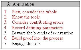
Table 3: The seven principles of professional surveying
The authors are publishing in essence 21 principles of professional
surveying, divided into three categories: application, behavior, and
context. Measurements are treated under category A (Tab. 3), where the
relationship with the science and the technology is discussed. Five out
of these seven rules are directly related to the acquisition and
treatment of geodetic data:
- First, consider the whole. “Working from the whole to the
part” is a well recognised surveying principle – working within the
control system, interpolation contains errors, extrapolation
amplifies them. Modern surveying technologies are such that the
“whole” (the control system) may be found to be deficient. The
“parts” (actual measurements) are of higher quality than the whole.
This may require the surveyor to consider changing the whole to fit
the principle of the parts.
- Know the tools. This principle is more important than
ever before. It is not sufficient to read the data sheet and to
listen to the vendor’s promises. As our measurement systems become
more opaque (black box systems) the necessity of regular and
meaningful checks increases. For complex systems like GNSS-receivers
we can only proof the entire measurement system by comparing the
final results with nominal values.
- Consider and analyze contributing errors. In most
applications there will be an expected accuracy of objects in space.
Uncertainties come from a number of sources, and they need to be
assessed and analyzed with respect to the unknown values. This
analysis is part of the design process before the real measurements
and part of the validation process after the measurements.
- Record the defining parameters. Record the adoption and
the transformation into the existing coordinate system. This makes
the whole survey traceable.
- Build proof into the process. A non-surveyor expects
reliability and accuracy from our profession. Today we have
efficient and accurate measuring systems, but this does not imply
that our measurements and the final results are error-free. We have
to proof our work with regular external checks. Repetitions control
only the measurement as such, not the whole process! The best
control for the entire work and the final results is checks which
are independent from the production methods.
Our modern and efficient equipment, which is at the same time easy to
use, seduces us towards the misapprehension: “External checks of our
work and our results are no longer necessary”. The above analysis
reveals the opposite. External overall checks of our work are of
particular importance today.
All rules which are in direct relation to the measurements can be
summarized by the request: “Master the entire measurement process”. All
rules are ageless, because there is no direct relation to a specific
step of technical development. Every user has to transform this general
rule into specific measures depending on the actual measurement task.
Mastering the entire process also comprises:
- choosing the optimal method of data acquisition and data
analysis
- mastering the data acquisition and data analysis, which means:
- the design of an appropriate strategy for acquisition and
analysis,
- the check of the survey equipment and the data
(observations), and
- the check and the validation of the entire system and the
final results.
4. THE ART OF MEASUREMENT
4.1 The Art of Measurement in the Past
Three hundred years ago there must already have been discussions
about the necessary qualifications of a surveyor: why else did the Swiss
mathematician Jacob Bernoulli say in 1684: “Surveying can only be
practiced correctly by somebody who has experiences in mathematics.
Therefore the state should not delegate this task – in contradiction to
a curious prejudice – to uneducated and ordinary people”?
The traditional fieldwork necessitated great versatility. The
surveyor in charge needed:
- Capabilities for carrying out precision mechanical work.
This was necessary for the setting-up and adjustment of the
instrument on every station.
- Skills in calculating.
- Sharp-sighted eyes.
- Physical robustness against unfriendly weather
conditions.
The requirement profile for field personnel became – with the
stepwise modernization of our instruments (cf. Fig. 1) – smaller and
smaller. If we measure with automated target recognition devices today,
only the need for physical robustness remains. And this requirement is
also weakened because observation times are shorter now than they were
in the past.
The observer’s influence on the observed angles is described in Table
4 according to the capabilities of his instrument.
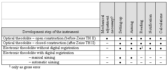
Table 4: The observer’s influence on the results of angular
observations
4.2 The Art of Measurement in the Present
Today a surveying project will only satisfy our clients when the
planning and design phase is done with a lot of care together with the
customer (and other relevant partners) and the desired final results in
mind. One big difference from the past is the need for real decisions
before the measuring even starts (Fig. 7).
Once the planning is completed, the field work starts with the check
of the entire measurement equipment. The FIG Working Group 5.1 developed
and published – under the chairmanship of the late Jean-Marie Becker
(Sweden) – procedures in four phases for routine checks of
electro-optical distance meters (FIG, 1994). These guidelines are still
valid and the rules can easily be extended to other instruments (total
stations, GNSS-receivers). The ISO Standard 17123 (ISO, 2009) prepared
by the Technical Committee ISO/TC 172, SC 6, now describes in eight
sub-standards the field procedures for different types of geodetic
instruments, namely theodolites (part 3), electro-optical distance
meters (part 4), electronic tacheometers (part 5), optical plumbing
instruments (part 7), and GNSS field measurement systems in real-time
kinematics (RTK, part 8).
If the equipment is working correctly and the quality of the results
is within the expected range, the measuring itself can start. In general
all the data are recorded on digital media. The important rule “build
proof into the process” is already respected during the fieldwork with
first checks for mistakes. Another important part of the data analysis
is the determination of the achieved accuracy. Once all the errors have
been detected and eliminated and the accuracy of the entire data is
determined, the real data processing can start.
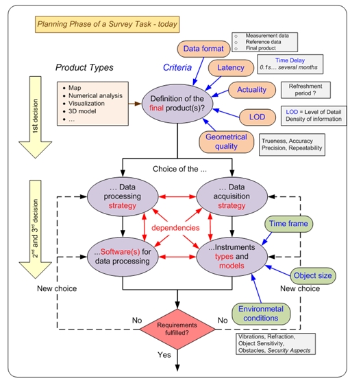
Fig. 7: The planning and design phase of an actual surveying
project.
5. CHANGES IN THE OPERATIONAL REQUIREMENTS OF A SURVEYOR
In the past surveying was quite clear. We had only a few measurement
methods and for each task there was a specific instrument. In contrast
to the current situation there was no choice between different types of
instruments for the same task. The execution of all measurements was in
general guided and controlled by regulations and there was no space for
individual decisions regarding the measurement procedure. Following the
established rules directly ensured good control of the acquired data. We
determined only points – in the horizontal positions or heights – and
the final results were either a map of predetermined fixed scale or a
numerical analysis (Fig. 8a).
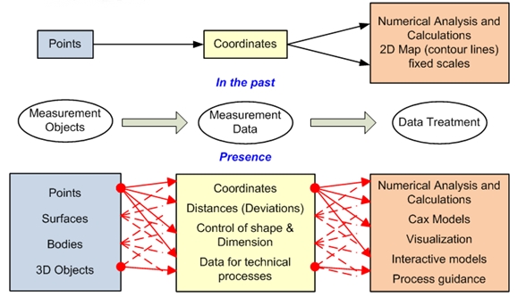
Fig. 8a: The surveying tasks in the past and today.
Today the possibilities and the actual demands are wider and differ
more. A surveying project can be divided roughly into three phases:
planning & design, data acquisition, and data treatment (Fig. 8b). In
former times they were executed one after the other. Today the planning
phase is – relative to the execution phase – much more extended than it
was before and the first part of the data treatment runs in parallel
with the data acquisition phase. Due to the far more efficient equipment
used for data acquisition and treatment, a project can be finished much
earlier than in past decades. At the same time the results can be used
for different purposes like planning, mapping at different scales and
with different levels of detail, volume determination, and so on.
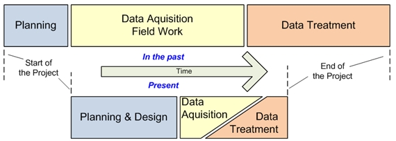
Fig. 8b: The different phases of a surveying project (not to
scale).
6. CONCLUSIONS
The art of measurement does still exist, but it has changed
significantly. In the past it meant “mastering the instrument”; today it
should be transcribed as “mastering the entire process”. The handling of
the instrument itself has become much easier, but the demands on the
surveying engineer today are much wider and more complex. Mastering the
process starts with decisions on the optimal measurement and data
processing strategy, followed by the optimal choice of instruments
(types and models). Today we often combine different measurement
systems.
For one task there are today several potential measurement systems
available, all of them having specific advantages and inconveniencies.
This is also valid for the data processing strategies including the
choice of appropriate software products. To make the optimal choice we
also have to consider the specific side conditions for the project. In
order to make these decisions in a professional way – which is part of
the modern art of measurement – we need knowledge:
- in physics and mathematics, especially regarding the
propagation of uncertainties and adjustment computations
- about the different measurement methods (advantages,
inconveniences, dependencies, perturbations, …)
- on the efficient checking of our instruments, and finally
- about the different possibilities for data processing
(side conditions, limitations, etc.).
Once the decision on a specific strategy and concrete types of
instruments is made, the realization can start. “Push the button” is
indeed the easiest part of the field work, but there still remain some
delicate manual operations like centering, leveling, and determining the
heights of the instruments or targets.
The art of measurement was limited in the past to the precise
acquisition of data (observations!). Today the data acquisition itself
has become much easier, but this does not mean that the whole
measurement process is easy to handle and free of errors! The
measurement process today is much more complex than it was decades ago.
Therefore we need surveying experts who are able to master the entire
process of data acquisition and data processing. Each measurement task
is different and has its own characteristics. We have to take special
care with an independent check and proof of the entire measurement
system and the final results. This exactly is the modern art of
measurement.
REFERENCES
BYRNE, P.M. & KELLY, G. (2007) “The ABC of x, y, z – 21 Principles
for Consideration by Surveyors and Other Geospatial Professionals”, FIG
Working Week, Hong Kong.
DEPENTHAL, C. (2004) “Stativbewegungen bei der Verwendung von
Robottachymetern”. Allgemeine Vermessungs-Nachrichten (AVN), pp.
227–233.
HELMHOLTZ, H. v. (1887) “Messen und Zählen erkenntnistheoretisch
betrachtet”.
INGENSAND, H. (2001) “Systematische Einflüsse auf praktische
Messungen mit dem Tachymeter und Digitalnivellier”. 54. DVW-Seminar
“Qualitätsmanagement in der geodätischen Messtechnik”.
DVW-Schriftenreihe, Band 42, pp. 120–137.
STAIGER, R. (1998) “Zur Überprüfung moderner Vermessungsinstrumente”.
Allgemeine Vermessungs-Nachrichten 105 (11/12), 365 – 372.
FIG: (1994) Publication No. 9, “Recommended Procedures for Routine
Checks of Electro-Optical Distance Meters”, available as pdf-download,
2007.
http://www.fig.net/pub/figpub/pubindex.htm
ISO Standard 17123 (2009)
http://www.iso.org/iso/iso_catalogue/catalogue_tc/catalogue_tc_browse.htm?commid=53732.
CONTACTS
Prof. Dr.-Ing. Rudolf Staiger
University of Applied Sciences Bochum
Lennershofstrasse 140
44801 Bochum
GERMANY
Tel. +49-234-32-10547
Email:
rudolf.staiger@hs-bochum.de
Web site: www.hs-bochum.de
 |


